Pills ‘n’ Chills and Deli Bakes

Yesterday I was in Tamworth for the summer food festival, enjoying excellent locally produced pork pies, sausage rolls and blue cheese.

After a gentle stroll around the town, I hopped back into the car and headed to Hopwas for a forage. For once, my walk took me along the canal in the opposite direction to the woods, a decision which may have been influenced by having read about a disused and reputedly haunted cemetery on Hints Road.

The graveyard once belonged to Hopwas Chapel, built in 1836 and dedicated to St John, and its resident ghost is said to be a small boy who can be seen by children (but not by a childish 39 year old it seems). The chapel was pulled down in the 1880s, as it was ‘full, small and inconvenient’, and replaced by the gorgeous St Chad’s Church up on the hill. A drawing of the old chapel can be seen here on the Stafforshire Past Track site. The old font survived and stands outside the new church, and the chapel’s bell still tolls in St Chad’s tower.  According to a report in the Tamworth Herald on Saturday 16th April 1898, the holy table from St John’s was made use of in the new Workhouse chapel.

St Chad’s, Hopwas, dedicated and opened in 1881

The old font from St John’s Chapel

Nearby, I found a cottage with the best name ever, which fitted in perfectly with the theme of the day, followed by a pill box in a field alongside the River Tame.

Too well guarded by nettles to even attempt to take a look inside, I plan to return as part of a much longer pill box walk along this section of the Western Command Stop Line Number 5 in winter. If I eat as much as I did at the summer festival, on the way home from the Tamworth Christmas food festival would probably be a good time….


Sources:

Click to access A%20Look%20Around%20St%20Chads.pdf

Trailgating

Perhaps the biggest faux pax you can commit about the place that gave the world Samuel ‘Dictionary’ Johnson is to spell the name incorrectly. Outsiders, please note that these days the only acceptable ‘T’ in Lichfield comes with biscuits and/or cake. The other way to wind up a Lichfeldian is to refer to Staffordshire’s premier heritage city as a town. En-route to the Guildhall Cells, perpetrators of this crime are taken past our central railway station to illustrate just how wrong they were.

"Lichfield City Station (6668724487)" by Elliott Brown from Birmingham, United Kingdom - Lichfield City StationUploaded by Oxyman. Licensed under CC BY 2.0 via Wikimedia Commons - https://commons.wikimedia.org/wiki/File:Lichfield_City_Station_(6668724487).jpg#/media/File:Lichfield_City_Station_(6668724487).jpg

“Lichfield City Station (6668724487)” by Elliott Brown from Birmingham, United Kingdom – Lichfield City StationUploaded by Oxyman. Licensed under CC BY 2.0 via Wikimedia Commons

Once they are in the stocks, heretics are then read to from the charters, currently held at the museum in St Mary’s, which include Queen Mary’s declaration of 1553 that Lichfield was not only to be a city, as granted by her brother Edward five years earlier, but also a county in its own right.

stocks

“OK it’s a city. I get it. I’m sorry. I’m from Tamworth”

This is the charter which gave rise to the annual Sheriff’s Ride (and its much more recent and considerably shorter spin-offs), a twenty mile perambulation of the current boundary of Lichfield. I had often sat and wondered whether at any point, the boundary was physically marked in someway (I do need to get out more) and just recently found an article written in the late nineteenth century which says it was, “formerly marked by wooden posts, but they have much deteriorated and in some instances disappeared. A renewal in iron of the most important has recently taken place”.

The Sheriff perambulating Cross in Hand Lane in 2014

The 2014 Sheriff perambulating Cross in Hand Lane.

Descriptions of the boundary of the City of Lichfield date back to the late 1700s. Back then it was only a sixteen mile round trip. Although in 1806, local historian Harwood said they were based on ‘ancient writings’, I understand there is no earlier written description of exactly what constituted Lichfield. However, there are piecemeal records showing some of the boundary changes over the centuries. And there must have been a fair few changes to get from a medieval town you could walk around in an hour to a city with a circumference of sixteen miles.

Last week I spent a sunny morning trying to trace the boundary of what would have been the medieval town. With the help of John Snape’s 1782 plan of Lichfield, it’s actually fairly easy to do, even for someone as illiterate at map reading as me.  Bishop Roger de Clinton surrounded the south part of the new town he had laid out in the late twelfth century with a bank and ditch and fortified the shared northern boundary of the town and Cathedral Close. Apart from a couple of inconveniently placed walls, you can pretty much walk the whole way around.

The moat marking the northern boundary of both medieval Lichfield and the Close. Described on Snape's map as a dry ditch or dumble.

The moat marking the northern boundary of both medieval Lichfield and the Close. Described on Snape’s map as a dry ditch or dumble.

Remains of the NE Tower, part of the Close's fortifications.

Remains of the NE Tower, part of the Close’s fortifications.

Thanks to archaeological investigations, we know that the town ditch in the St John’s Street area was about five metres wide, two metres deep and inevitably, was also used as a public tip.

Castle Ditch plaque

The driveway passing the LD Council Offices follows the line of the town ditch, and there's a plaque there telling you that.

The driveway passing the Lichfield District Council Offices follows the line of the town ditch, and there’s a plaque there too.

When a section in the Council House car park was excavated in 2008, archaeologists discovered the sole of a woman’s shoe from the twelfth century, part of a medieval jug and the remains of a medieval dog’s head.

This plaque is located at the junction of Lombard St, Stowe Rd and George Lane

This plaque is located at the junction of Lombard St, Stowe Rd and George Lane.

Back to plaque, looking up George Lane which was actually once part of the town ditch

Back to plaque, looking up George Lane which was actually once part of the town ditch, possibly until the 16thc

Snape’s plan also marks the gates, or bar(r)s, at the main entrances into and out of Lichfield, and there are plaques at each of the locations, with the, hopefully temporary, exception of the Sandford Street gate. The building it was mounted on has recently been demolished but I’m sure the plaque is being kept safely somewhere….

Perhaps the best known of the gates is the one at St John Street which is still recalled in the name of St John the Baptist without the Barrs. You know, the place with all the chimneys. As the name indicates, this stood just outside the gate and started out as a hostel for those arriving when Lichfield was closed for business for the night, many of them pilgrims on their way to see the shrine of St Chad at the Cathedral.

st john sign

On the subject of names, the section of the ditch running from the gate on Tamworth Street, to the gate near St John’s Hospital was known as Castle Ditch, and this, alongside hard evidence in the form of stones turning up nearby and evidence of a slightly more fluffy nature in the form of myth and folklore, has caused endless speculation as to whether Lichfield ever had a castle proper alongside the fortified Close with its towers, turrets and strong walls.

Remains of south gate tower leading from dam Street to The Close. Excavated in the 1980s

Remains of one of the towers which were part of the south gate between Dam Street and The Close. Excavated in the 1980s.

So, plenty of opportunities to get out more here. I think the two mile-ish walk around the ditch will make an excellent Lichfield Discovered adventure. I would also happily walk sixteen miles to find one of those old iron boundary markers although I may be on my own with this. It’d also be interesting to see how Lichfield has burst its boundaries over the years gobbling up all of the surrounding settlements, so much so that it’d take you six hours and twenty four minutes to perambulate the current perimeter, according to this walking calculator I’ve found.  And that doesn’t even include getting distracted by other things or stopping off at the pub. It’ll have to wait though, as right now I’m off on an expedition to Borrowcop to see if I can capture Lichfield Castle.

1)  If we’re doing names, then I have to mention that Bakers Lane was once known as Peas Porridge Lane. Just because.

Broken Record

The ‘Heritage at Risk’ register for 2014 was published by English Heritage today. The Register includes grade I and II* listed buildings, grade II listed buildings in London, and all listed places of worship, scheduled monuments, registered parks and gardens, registered battlefields and protected wreck sites assessed as being at risk.

There are eight entries from around the Lichfield District this year, including scheduled monuments at Alrewas, Elford, Fradley and Streethay, the Fazeley and Bonehill conservation area and three buildings, namely, the Angel Croft Hotel on Beacon Street, the Manor House at Hamstall Ridware and the old church tower at St John’s in Shenstone.

Angel Croft Railings

The Angel Croft Hotel has been deemed ‘At Risk’ for many years, but there is now a glimmer of hope that Lichfield’s fallen Angel may be saved. This year’s entry notes that, ‘permission has been granted for conversion to apartments with an agreement to secure the repair of the gates and railings. Work should start in the summer’. Time will tell, but I really do hope that 2014 will be the last time that the Angel Croft appears on the register.

Whilst the plight of the decaying Angel Croft is well known in Lichfield, other local entries on the list may be less familiar, but no less worthy of salvation. Fazeley, according to Lichfield District Council, ‘represents a remarkably intact industrial community of the period 1790-1850. It contains all the principle building types necessary to sustain the community; terraced housing, mills, factories, a church, a chapel, public houses, a school and prestigious detached Georgian houses’. They go on to say that, ‘the waterways, pools and associated structures built by Robert Peel Snr are an important part of Fazeley’s industrial heritage and have archaeological significance. Their significance extends beyond just the immediate locality as they represent one of the most important water power systems dating from the early part of the Industrial Revolution. As a contrast to Fazeley’s industrial heritage, the appraisal tell us that, ‘the historic hamlet of Bonehill…. is an important remnant of the areas agricultural past and despite the developments of the twentieth century still retains a peaceful, rural feel. It has a direct association with the nationally renowned Peel family’.

Yesterday, Gareth Thomas, GIS Manager at Lichfield District Council, uploaded a number of photos from their archive to Flickr. It just so happens that alongside the reminiscence-tastic images of Lichfield shops and businesses, Gareth has uploaded a number of photographs of the conservation area at Fazeley and Bonehill, showing us just what is at risk here, hopefully inspiring us to pay a visit ourselves.

Taken from Lichfield GIS photostream, Flickr

Taken from Lichfield GIS photostream, Flickr

Taken from GIS Lichfield photostream, Flickr

Taken from GIS Lichfield photostream, Flickr

Taken from GIS photostream, Flickr

Taken from GIS Lichfield photostream, Flickr

Taken from GIS Lichfield, Flickr

Taken from GIS Lichfield photostream, Flickr

Also making an appearance in both the Lichfield District Council’s photo collection and on the ‘At Risk’ Register, is the Manor House at Hamstall Ridware. The pictures speak for themselves – the condition of watchtower is so bad that it is deemed at risk of collapse. Perhaps appropriately for something that may not be long for this world, I first caught sight of it from the churchyard of St Michael’s and All Angels and managed to find out a little about its history here.

Taken from GIS Lichfield photostream, Flickr

Taken from GIS Lichfield photostream, Flickr

Taken from GIS Lichfield photostream, Flickr

That’s quite a crack! Taken from GIS Lichfield photostream, Flickr

Hamstall Ridware manor 3 Hamstall Ridware manor and church

Over in Shenstone, it seems there are ongoing discussions between the council, the Parish Council and the church regarding the old tower. At least for the time being, the structure is ‘considered stable’ – let’s hope that they all start singing from the same hymn sheet soon.

Old tower at St John's Shenstone, by Jason Kirkham

Old tower at St John’s Shenstone, by Jason Kirkham

Same time, same places next year folks? Let’s hope not…


Thanks to Gareth Thomas and Lichfield District Council for the archived photos of Fazeley and Hamstall Ridware, and to Jason Kirkham for his photograph of the old tower of St John’s at Shenstone.

Bad Neighbours

Legend has it that in July 1403, two feuding neighbours from opposite sides of the River Trent set out to fight on opposite sides at the Battle of Shrewsbury. Sir William Handsacre was for the rebel Sir Henry ‘Hotspur’ Percy and loyal to King Henry IV was Sir Robert Mavesyn, whose name was said to derive from the French malvoisin meaning ‘dangerous neighbour’. At Bridge Meadow, near to the site of High Bridge, it’s believed that the paths of the two enemies crossed, as did their swords. Living up to his name, Mavesyn killed Handsacre but his victory was short-lived and he met his end at the Battle of Shrewsbury, ‘standing with the King and fighting by his side even unto death’, if the epitaph on his tombstone in the church of St Nicholas at Mavesyn Ridware is to be believed.

The church dates to the mid-twelfth century and stands near to the site of the manor house, which Sir Robert would have once called home. The medieval house was replaced in the early eighteenth century by what William Pitt described in 1817 as, ‘a convenient box, pleasantly situated for a summer residence’. However, still in existence and visible from the churchyard is the ancient timber framed gatehouse, built using trees felled in late 1391 or before the spring of 1392, according to dendrochronology.

SAM_1511

The Church of St Nicholas, Mavesyn Ridware

The old gatehouse at Mavesyn Ridware, seen from the churchyard of St Nicholas

The old gatehouse at Mavesyn Ridware, from the churchyard of St Nicholas

The final resting place of Sir William is unknown but in 1866, William Painter of The Red Lion Inn at Handsacre wrote a letter on the matter to George Griffith, author of ‘The Two Houses: A Staffordshire Tragedy’, a dramatic work based on the events of 1403. According to Mr Painter, when the church of St John the Baptist in Armitage was rebuilt in the mid-nineteenth century, a stone coffin was discovered in the north wall. Inside was a skeleton, with a full set of teeth and a sword. Local tradition had it that these were the mortal remains of Sir William Handsacre. (1)

In 1972, Sir William must have turned in his grave (whether in St John’s or elsewhere) when vandals destroyed much of his former home, Handsacre Hall. In a bid to preserve what remained, I understand that the surviving fragments were moved to Avoncroft Museum in Bromsgrove, where again dendrochronology was used to date the timbers, giving a suggested date of around 1310, with some reused timbers from an earlier hall. According to the report by the Staffordshire Archaeological Society, the house had been derelict for at least six years prior to this and a photograph of the building taken around this time can be found on Staffordshire Past Track here. In its heyday it looked like this.  

SAM_1629

Information board at the site of Handsacre Hall

Nowadays the site is a Scheduled Ancient Monument, still surrounded by a moat, ten metres wide and four feet deep, but also by a housing estate. It’s said that on the island in the centre there are visible brick and sandstone remains and no doubt there is plenty of evidence of past lives at the hall below ground. Visiting in high summer, the only thing I could see (and feel unfortunately), were stinging nettles. Will be interesting to see what a return visit in winter will reveal.

Part of the moat which once surrounded Handsacre Hall

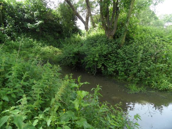
Part of the moat which once surrounded Handsacre Hall. And nettles. Lots of nettles…

Sources

Staffordshire Archaeological and Historical Society Volume XV Transactionf for 1973/4 – Stanley R. Jones Handsacre Hall, Armitage: a note on its destruction

http://ridwarehistory.yolasite.com/mavesyn.php

Staffordshire HER 09638

Greater Medieval Houses of England and Wales, 1300 – 1500: Volume 2 by Anthony Emery

A topographical history of Staffordshire by William Pitt.

Shiver Me Timbers

Where there’s an old wooden beam, there’s often a rumour that it originated on an old ship. It’s a bit of folklore that I keep encountering time and time again, even here in landlocked Lichfield and Staffordshire. Back in 2011, I visited St John’s Hospital during the Lichfield Heritage Weekend and heard that the Master’s House, which was originally the canons’ and pilgrims’ hall and enlarged by Bishop Smythe in the late fifteenth century, was built using beams from galleons. On the ghost tour earlier this month, we were told that that wooden beams in an entry running alongside the Walter Smith butcher shop on Market Street came from old ships and when researching the Four Crosses Inn in Cannock for a piece in the Chase Gazette, I once again came across claims that the oldest part the building, dating to 1636, made use of timber from ships.

Alongside butcher shop on Market St. Beams are covered in stripy plastic on this photo unfortunately, but every now and again the alley is open for you to go and take a look...

Alongside butcher shop on Market St. Beams are covered in stripy plastic on this photo unfortunately, but every now and again the alley is open for you to go and take a look…

Last night, a discussion on Twitter about those other two old inn regulars – ghosts and Dick Turpin – moved onto the subject on the use of old ships’ beams and a quick google search revealed yet more old Midlands buildings making the claim including the Ye Olde Gate Inn in the Derbyshire village of Brassington and the appropriately named Old Ship Inn in Worksop, Nottinghamshire. Could there be any truth in any of these claims? As someone unfamiliar with the world of carpentry, I was interested to read a discussion between some experts on the matter which you can read here. Just as I was sure that this myth was pretty much busted I clicked on the link in the penultimate comment, which took me here – a website telling the story of the lost Brig Elizabeth Jane, launched in Nova Scotia in 1817 and abandoned off the Yorkshire coast in 1854. Incredibly, the name board and the port of registration board were discovered in a ceiling in Robin Hood’s Bay in 2003 leaving no doubt that this was one case where the rumours were true.

A one off perhaps? It seems not as shortly aftewards I came across the website of the Chesapeake Mill in Hampshire, where the beams, joists and floors are all said to have been constructed from the United States frigate ‘The Chesapeake’. On a slightly gory note, an extract from ‘The Navy and Army Illustrated’ in 1898, included on the  mill’s website, describes the joists as ‘covered with the blood of the men who were killed and wounded in action, and many bullets are embedded in them; in fact a good many of the timbers seem quite soaked with blood’.  You should read the full story on their website here it’s a fascinating place!

Closer to home, I found an article on Graiseley Old Hall in Wolverhampton which says that some of the purlins (now there’s a word I didn’t know existed until today!) in the roof came from old ships. What’s also interesting about this article is that it acknowledges that similar claims are made about many buildings, but that hard evidence to support it only exists in a few and then gives us a possible explanation for this, suggesting that often it could be a reference to the quality of the timber rather than where it came from.

I’d really like to hear of any more examples that people know of where old ships timbers are said to have been used, proved or otherwise.  When it comes to myths and folklore, we shouldn’t always believe everything we hear, but we should definitely listen in the first place. You never know where a story will lead.


Bones of Contention

Last week, together with other members of the Lichfield Discovered group, I enjoyed a Gruesome and Ghostly tour around the city lead by one of Lichfield’s Green Badge Guides. Some tales were familiar (although it’s always fascinating to hear someone else’s version of a story you know), others were complete revelations. I was particularly intrigued by the story of an ancient adult male skeleton, apparently discovered with the remains of a tiny baby in his arms when an access road was being built behind Bakers Lane. (1) Obviously when listening to stories in these circumstances, you’re never quite sure where truth ends and anecdote, myth and legend creep in, and I was interested to know whether there was any substance to this story. As of yet I haven’t been able to find anything on this particularly, but as you might expect, searching for skeletons in Lichfield turns up all sorts of intriguing information….

In 1925, the Tamworth Herald got very excited when it heard that workers digging a trench in the grounds of St John’s Hospital in Lichfield had discovered human remains, announcing that the skeletons discovered were ‘probably over 700 years old’ and that they may be ‘priors and their bretheren’. The Rev John Ernest Auden, chaplain at the hospital, wrote to the Lichfield Mercury to set the record straight – yes, ten bodies had been discovered but it was unlikely that they were seven hundred years old, or even half that. It was also unlikely that they were priors as such burials were usually discovered alongside an article of their service, often a chalice and patten, as had been discovered in 1917 at the former leper’s hospital at Freeford (2).  It was much more likely that they were old residents of the hospital. Archaeological evidence in the form of tiles and pottery found alongside the bodies suggested that they had been there for around two hundred years. Rev Auden also recalled how, when he was curate of St Mary’s in 1886 to 1889, he could remember funerals taking place at St Johns and several older people he had known, including former resident of the hospital Henry Cartmale and City Coroner Charles Simpson, could recollect burials taking place in the grounds. Rev Auden also pointed out that there were three fairly modern gravestones under the Yew Tree supporting this.

Part of the courtyard at St John’s Hospital

Apparently one woman had protested at ‘the hideous sacrilege and desecration in using ground solemnly consecrated and dedicated as God’s acre for ever, for a bed for sewers’, and so Rev Auden took the opportunity to reassure her, and anyone else that was concerned about the work that was being carried out, that the bones had been collected and reburied together and that the Hospital Quadrangle would soon resume its peaceful aspect, plus the manholes.

Although they did make assumptions in this particular instance, to be fair to the Tamworth Herald, evidence for much older burials, in and around the hospital, was discovered in 1967, when according to the County History, a medieval burial was found during alterations to the almshouses. In June last year, Annette Rubery and local newspapers reported that further remains were found just one metre below the pavement outside the hospital, when workers were repairing a gas pipe, although I don’t think the date of this burial was ever confirmed?

In another post, I’ll look at ‘Councillor Moseley’s Graveyard’, the nickname given to the site of the Friary after Thomas Moseley secured permission to excavate the site in the 1930s, uncovering several skeletons and other archaeological remains, and also the area in and around Lichfield’s Cathedral Close, where amongst other discoveries, a very unusual burial was reportedly found within the walls of one of the buildings in the early eighteenth century. They don’t call this the Field of the Dead for nothing you know (4).

Notes:

(1) One of the reasons I find this particularly interesting is that it seems unusual that it’s a male skeleton with a young child. Over in St Michael’s churchyard, the remains of an adult with a child were discovered, but this was thought to be a mother who had died in childbirth (and was of course in consecrated ground). For more information on that see here. Also, it makes you think about past uses of land and what discoveries like this can tell us. Edit: I’ve just re-read the report and the actual wording is ‘an adult and tiny baby found buried together…it is possible they represent a mother and child who died at childbirth’, so I should make it clear.

(2) For more information on the human remains discovered at Freeford, and thought to be related to the fomer lepers hospital there, see here

(3) Mr Charles Simpson b. April 9th 1800. Solicitor, Town Clerk and Coroner for the City of Lichfield, and Clerk of the Peace for Staffordshire 1825.  d. April 22nd 1890Details from the Shrewsbury School Register 1734 – 1908, edited by….Rev J E Auden!

(4) As I’m sure everyone knows by now, Lichfield doesn’t really mean Field of the Dead, it’s just an old myth that’s most likely stuck because it’s more evocative than the real meaning of the the name which is thought to be something like ‘common pasture in or beside the grey wood’. For more on the place name and yet more Lichfield bones see here 

Sources:

:Lichfield Mercury Archive

Tamworth Herald Archive

www.annetterubery.co.uk

Hospitals: Lichfield, St John the Baptist’, A History of the County of Stafford: Volume 3(1970), pp. 279-289

Shrewsbury School Register 1734 – 1908, edited by Rev J E Auden

Wall Street Journal

Sunny days should be spent out and about under blue skies, not shopping for bathroom suites in Cannock. However, needs must and afterwards we made up for it by continuing the bath theme in much more pleasant surroundings, spending the afternoon at the Roman bath house at Wall. Although it’s only about three miles away from Leomansley, it’s a while since I’ve been to the ruins of the Roman settlement of Letocetum. My last visit  was in 2011,during an open day organised by the Friends of Letocetum for the National Archaeology Festival. Another visitor on that day, who sadly I didn’t meet, was the late Mick Aston (wearing a stripy jumper of course!), who had one of his first experiences of archaeology at the site as a young man under the guidance of Jim Gould FSA.

Remains of the guest house and bath house at the Roman settlement of Letocetum

Roman occupation at the site is thought to have begun with the establishment of a military site to protect this important route, later developing into a staging post where those travelling along Watling St could rest and recuperate at the guest house and bath house, (it is the remains of these buildings which are still visible) and eventually a small town.  You can see another Roman road, running between the remains of the two buildings on the site, with some of the original cobbles still intact.

Not quite on Watling Street scale, but a Roman road nonetheless.

After looking around the ruins, we followed the Wall Heritage Walk (available from the museum) which took us along more ancient routes – the greenways and sunken lanes that surround the village, thought to be old drovers’ roads.

I’m including this, not because I fancy myself as a wildlife photographer, but because I am grateful to the subject for being the only butterfly ever to have stayed still long enough for me to take a photo!

As well as enjoying the views and the wildlife of the hedgerows, I also couldn’t help looking out for buildings in the area that had used stone from the ready made quarry nearby!

Are these Roman stones I wonder?

One of the lanes runs past St John’s church. Built in the late 1830s, in comparison to the ruins it overlooks, it’s a young whippersnapper of a building. The architects were George Gilbert Scott and William Bonython Moffat, who it seems were also working on Lichfield’s new workhouse at St Michael’s around the same time.

One of the questions that seems to be subject to much discussion here is, could earlier places of worship once have existed on the site? There has been speculation that there was once a shrine to Minerva here, based on an account of a man who worked draining the lands around Wall. Asked if he had ever found anything in the course of his work, he told how as well as finding lots of old coins, he once found an earthenware figure that he described as being as big as a man, but not a man due to having a bust, and also not a woman as it had a queer dress and a man’s cap like a soldier’s helmet. And what did he do with this amazing find? Prepare to weep – he used it to mend a drain.

However, before getting too upset we can perhaps take some comfort in the fact that Jim Gould (who as well as working extensively at Wall explored and wrote about the archaeology of many of the other sites around here) was not convinced that the statue ever existed, the story being “from an unknown source, of the finding of an impossible statue, by an un-named man, at an unknown spot and date (1). A good lesson that no matter how appealing some stories may seem, they should be taken cum grano salis. 

Entry is free but the museum is only open on certain weekends so check first!

Thanks to archaeologists like Mr Gould and others, a great deal of the history and significance of the site has already been discovered, although it seems there are still plenty of crop marks and questions out there (including the relationship between Letocetum and what was to become Lichfield) to keep future generations of archaeologists busy. However, just as sunny days ideally shouldn’t be spent shopping on retail parks, places such as Wall ideally shouldn’t be explored through words and photographs along, but physically instead. The museum even has a collection of objects you can touch! Instead of using this post to further summarise the history of the site (especially as others will have done a far superior job elsewhere!),  I’d rather encourage you to go and have a look for yourself.  In case you need any further convincing, entrance to the ruins and the museum is free and the heritage leaflet I picked up there was worth every one of the 20 pennies I paid for it.

Slightly gratuitous photo of Roman army re-enactors, English Heritage Festival of History 2011

Sources:

(1) http://www.sahs.uk.net/Volume%20XXXIII.pdf

Wall Heritage Walk

Pastscape Record for Letocetum

Perspexive

This morning, I went to the dentist. On the way home I walked past St John’s Hospital. With the sun shining, I decided to pop in and allow myself a minute to take in the lovely surroundings and the calm atmosphere of the courtyard, before heading home.

At least that was my intention. As hospitable as ever, someone in the courtyard came over to welcome me, and invited me to have a look around the chapel. Never one to miss an opportunity to be nosey, I accepted with thanks.

I have been inside once before, but that visit was dominated by standing in front of John Piper’s striking window for the first time. Today, I sat on a back pew and found myself next to a perspex window. A small sticker told me that the stonework behind the perspex was the remains of a Norman water stoup. I understand that this would once have held holy water, into which those entering the chapel could dip their fingers, and make the sign of the cross. Apparently, many stoups were destroyed during the reformation but whether this is the case here I don’t know.  As the chapel has been heavily restored and altered over the centuries, I was delighted to have this chance encounter with part of the older fabric of the chapel.   Unfortunately, as I hadn’t anticipated there being many photo opportunities on a trip to the dentists, I had no camera. But the chapel is open everyday until 5pm, so if you can, please do go and take a look yourself, and enjoy visiting the grounds at the same time.

This got me thinking about the idea of layers of history within buildings, where generations of people have made their mark, by accident or by design, for better or for worse.  When I was volunteering at the Guildhall, someone told me I could get out using the back door. It was news to me that there was a back door but once through it, I made the even more exciting  discovery that  traces of the older building were still in evidence. For example, whilst the main hall and the front of the Guildhall date to the mid 1800s, the blocked window on the photograph below is thought to date to the 16thc.

Brickwork from different periods, round the back of the Guildhall

Another couple of examples to be going on with – what’s gone on here with all the different brickwork at this house in The Close?

This metal….thing, above a restaurant on Bird St, must have played some role in the building’s past, but what?

And when we’re talking about layers of history, should we also consider the present and future of buildings? I notice that the Angel Croft hotel has unsurprisingly made its annual appearance on the English Heritage At Risk register…..

Sources

http://www.british-history.ac.uk/report.aspx?compid=37864

Cross City

There’s some evidence that there were several stone crosses in Lichfield, although as far as I know, no physical remains have ever been found.

The most well documented of these is the market cross. According to the Lichfield volume of the History of the County of Stafford (1), a market cross stood north of St. Mary’s in the late Middle Ages and then some time around 1530, Dean Denton surrounded it with eight arches and added a roof  to keep the market traders dry. The building was topped with eight statues of apostles, two brass crucifixes on the east and west sides, and a bell, as you can see in this picture on the Staffordshire Past Track site.    The cross was destroyed in the civil war, and replaced with a market house, as shown in the illustration below (although it is referred to as a cross on the notes?) which has also now disappeared.

Taken from John Jackson’s book, History of the City and Cathedral of Lichfield, 1805

There is a possibility that there was a preaching cross in the grounds of St John’s Hospital as documentation shows that Dean FitzRalph preached outside in the cemetery. (2) Information on this specific example is really sketchy, but there is a surviving preaching cross in Bloxwich which you can read about in a great article on The Borough Blog.

More evidence exists for a cross at the junction of Tamworth St and Lombard St. There is a cross like structure shown there on John Speed’s 1610 map, and in 1805 Thomas Harwood wrote that there was a stone cross in Tamworth St. (3) There are also a couple of references in old property deeds such as one from April 1316 describing a ½ burgage in street between the Stone Cross and Stow Gate.(4)

The Market Cross and the Stone Cross at Tamworth St can be seen depicted on John Speed’s 1610 map of Lichfield

A cross apparently stood near Cross in Hand Lane in Lichfield, giving rise to a theory that it this is where the lane got its name from (the other theory is that is was a pilgrimage route, to St Chad’s shrine, where people would walk with ‘cross in hand’. The route has recently been incorporated into a new pilgrimage and heritage route called Two Saints Way). Harwood said,  “(Beacon Street) extends from the causeway over the Minster pool which separates it from Bird Street to houses at the extremity of the city called the Cross in the Hand and where stood an ancient cross ad finem villas.’ The pastscape record for the cross is here.

This week I came across another reference, this time Bacone’s Cross, and which was also thought to be in Beacon St, at the end of the town. Was the ancient cross at Cross in Hand Lane and Bacone’s Cross the same cross?

The Bacone’s Cross/The Cross in Hand and the Tamworth St cross were both situated at the ends of the town. Does this mean that they were boundary markers of some sort?  If so, could there have been more crosses marking other places on the City’s boundary.  There were city gates at both Beacon St and Tamworth St.  However, the probable sites of the gates don’t correspond exactly with the probable sites of the crosses e.g. the above example says ‘between the Stow Gate and the Stone Cross’.

Tamworth Gate plaque on Lee Garden Chinese Restaurant Credit: Ell Brown (taken from flickr photostream).

In the absence of more information about Lichfield specifically, I looked elsewhere to see if crosses would have been used to mark boundaries. St Albans was surrounded by a ditch, like Lichfield (and there’s a link with the story of the  Christian martyrs but that’s a bit too much of a tangent for now!). The History of the County of Hertford, says this about the city’s boundary (5)

Crosses were at an early date erected at important points in the line of boundary, and at each of the entrances to the town, namely, the Stone Cross or North Gate Cross  at the north on the Sandridge Road, the Red Cross in Sopwell Lane, at the entrance by the old road from London, the Cross with the Hand in Eywood Lane, the Black Cross, probably at the angle where Tonmans Dike goes from the boundary of the houses in Fishpool Street towards the Claypits, and St. John’s Cross at an angle of the boundary in what is now known as Harley Street, but lately as Mud Lane.

It’s interesting to see that some of the names are the same – Stone Cross, Cross with the Hand – but I don’t want to start jumping to conclusions until there is much more evidence!

Finally, there is a document relating to property in Freeford (4), which describes ‘three selions of land at Lichfield, near Le Hedeless Cross, on the road towards Freeford’ in the time of Edward III – Henry V. Does this refer to the Tamworth St Stone Cross, or another cross altogether?

What happened to these crosses? Time? Religious differences? Where did they end up? There’s something in one of my all time favourites book that gives me hope (possibly misguided) that there is a chance, no matter how slim, that things that have long been thought to have vanished might turn up again one day in some form or another. In England in Particular (6), in the section on Wayside and Boundary Crosses, it says that,

Some crosses have been found in hedgebanks, with shafts used as gateposts. A number have been found by researching field names:two fields called Cross Park revealed previously undiscovered stones.

Fingers crossed!

Edit:

In view of the above, I thought it’d be worth having a look at field names etc, in Lichfield. There is an entry in an transcribed inventory relating to the real estate of the vicars that says Deanslade: Falseway to cross called Fanecross (4). There’s a Banecross on another transcription and I think one of these could be down to a typo and that they could be the same place, There is also an entry for a place known as Croscroft, which was on the road to Elford, near St Michael’s Churchyard (3)

Another edit:

I was hoping there would be an ancient cross somewhere in Lichfield. Well, I finally found one! Actually that’s a fib. What I found is a photograph in a book of archaeologists finding one. A decorated cross shaft was discovered built into the foundations of the north wall of the nave of Lichfield Cathedral. It’s thought to be Saxon or Saxo-Norman, and could be a surviving remnant of the earlier church on the site. I wish I could share a photograph here, but all I can do is tell you that it’s on plate 1 in the ‘South Staffordshire Archaeological and Historical Society Transactions 1980-1981 Volume XXII’ book, on the local history shelves at the library!.

Sources:

(1) Lichfield: Economic history’, A History of the County of Stafford: Volume 14: Lichfield(1990), pp. 109-131http://www.british-history.ac.uk/report.aspx?compid=42349#s6

(2) Hospitals: Lichfield, St John the Baptist’, A History of the County of Stafford: Volume 3(1970), pp. 279-289

(3) The history and antiquities of the church and city of Lichfield by Thomas Harwood

(4) Collections for a History of Staffordshire Part II- Vol VI (1886), William Salt Archaeological Society

(5)  ‘The city of St Albans: Introduction’, A History of the County of Hertford: volume 2 (1908), pp. 469-477

(6) England in Particular, Sue Clifford & Angela King for Common Ground

Hospital Ward

In 1781, John Snape carried out a census of Lichfield, making a list of the different wards of the city in the process. The wards are as follows: Bacon St (now Beacon St), Bird St, Sandford St, Sandford St below the water, St John’s St, St John’s St above the bars, Sadler St (now Market St), Bore St, Wade St, Dam St, Tamworth St, Lombard St, Stow St and Greenhill.

I think that these are the wards depicted by the flags hanging from the ceiling of the Guildhall, discussed here in my previous post. Now that I’ve finally made it back into the Guildhall to check which flag corresponds with which ward, I’m going to take each one in turn, trying to discover the significance of the design on each flag. Some I’m pretty sure of, others I’m really not (I’m talking about you Sandford St below the water ward!)


Photo from Ell Brown via flickr

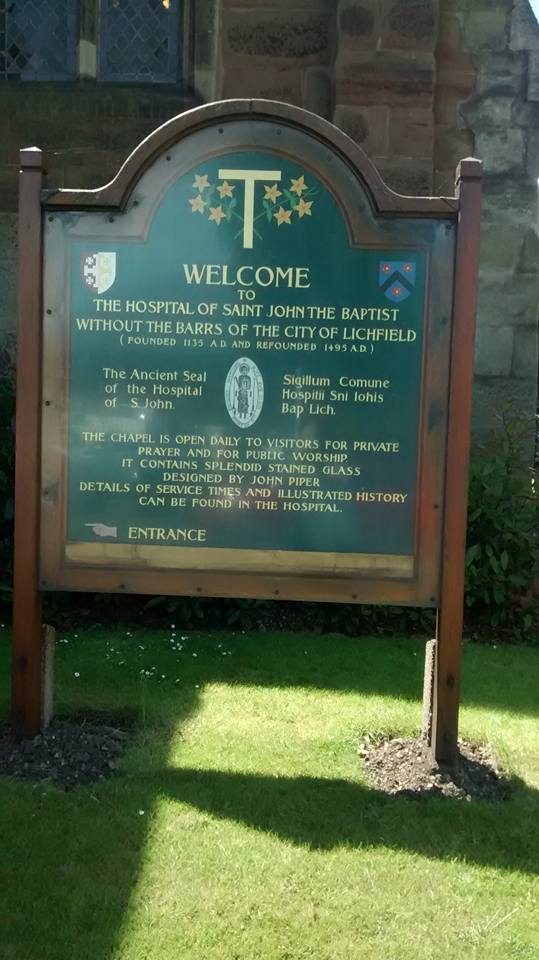
 I’m starting with the flag that represents St John’s ward. Not only is it my favourite of the banners, it’s also seasonal with the feast of St John’s (or Midsummer’s Day) on 24th June. St John St gets its name from The Hospital of St John The Baptist (the place with the chimmneys!). The design from the flag is also on the board outside St John’s chapel, but what does it represent? The yellow flowers must be St John’s Wort, associated both with the saint and midsummer. What are the flowers growing around though?  Well, it’s taken a lot of googling but I think that it’s St Anthony’s Cross (also known as the Cross of Tau), often associated with St Francis. This possibly explains its inclusion, as the site of the Franciscan Friary lies within this ward . Part of the old Friary wall can still be seen on St John St.

Please feel free to join in with the speculation on this and any of the other flags that follow!

Photo of St John’s board from Ell Brown’s Lichfield Group photo set on his flickr stream, included with thanks.