The Leomansley Witch Project

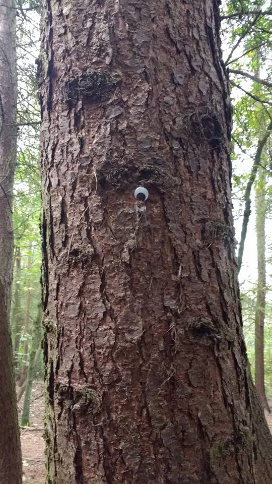
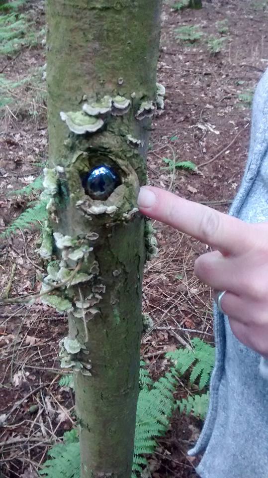
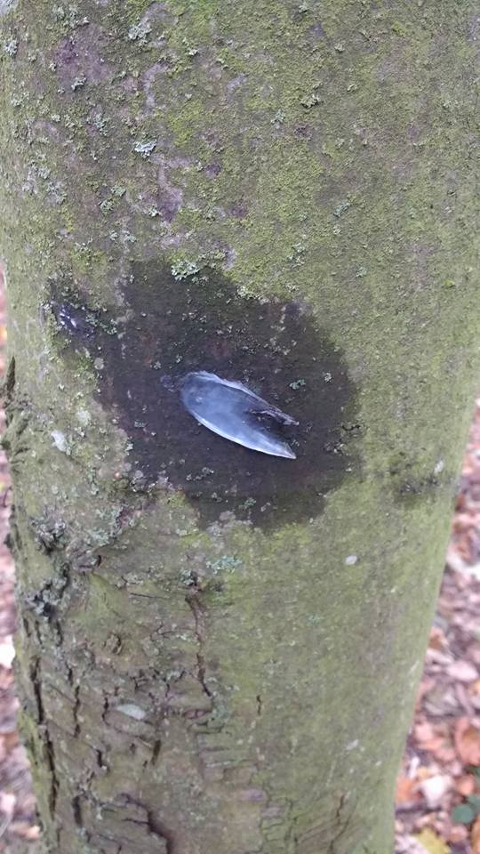
Imagine you’re watching a horror film. A woman heads into ancient woods which are shrouded in mist. And before long, she comes across a tree. With an eye stuck to it.

leomansley-mist

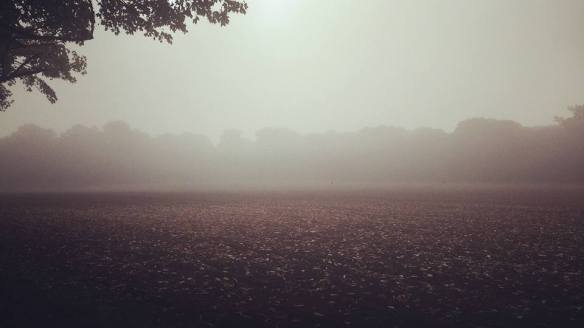
Chances are at this point in the film, you’d be shouting, ‘Don’t go in there. Run away!, whilst feeling smugly confident behind your cushion that you’d never be as stupid as to stay hanging around in mist shrouded woods where there are eyes stuck to trees. Well, I was in Leomansley Woods earlier this week. It was shrouded in mist and there was an eye on a tree. But did I leg it? No. And not just because I don’t do running under any circumstances.

woods-oct-16-2

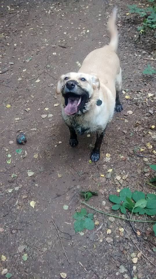
If something wicked that way had come, I had Finn the swamp dog to protect me and my experience of fighting off a clown in Beacon Park earlier in the month to draw upon. Crucially though, I know and love these woods and consider the tokens and trinkets that have been appearing there since the summer more curious than creepy, possibly symbols of someone else’s affection for them.

finn-swamp-dog

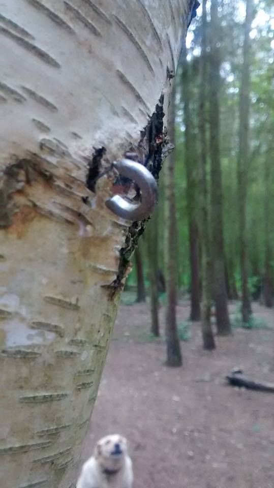
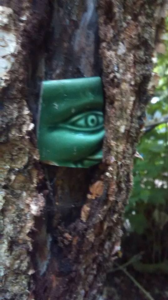
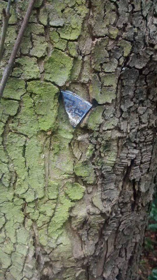
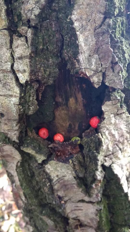
Back in 2004, when I was a newcomer to these parts, I remember getting a call from my sister telling me to go and take a look in the woods as somebody, or more likely somebodies, had created works of art in amongst the trees. There were mosaics created from leaves and petals, clay faces sculpted onto the trunks of trees and brightly coloured papers hanging from their branches. For reasons I can’t remember, I didn’t take any photographs but I can clearly recall the sense of mystery and magic someone had created in the woods that day. We never discovered who or why and there was no encore. The seasons turned and the years went by and then, early this summer, we began to notice things. At first it was subtle. A pebble placed here, a strip of silver birch bark there. It was the first piece of pottery appearing lodged in the knot of a tree that convinced us this was more than the handy work of squirrels and our overactive imaginations. Dog walks took on a new dimension as every day seemed to bring something new. I’m sure at its peak, others were joining in and making their own contributions. And this time I did bring my camera.

woods-june-2016-3

leomansley-woods-june-2016

woods-june-2016-6

woods-june-2016-4

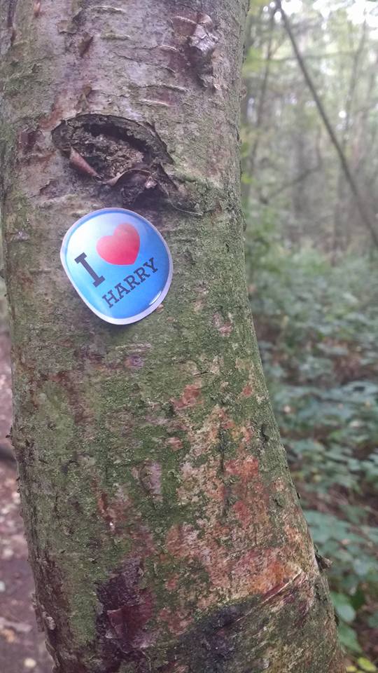
As the summer faded, the activity seemed to wane, and I’d assumed there would be no more. The other half took over the dog walks for a while but recently, for reasons involving a prolapsed disc, I took up the lead once again. Many of the original tree decorations had vanished but a handful of hawthorn berries, melted candle wax and a tickle of feathers (that’s genuinely and rather pleasingly the collective noun for them) had taken their place. Interestingly, others seem to be joining in once again, including the Leomansley contingent of the One Direction fan club.

leomansley-wood-berries

woods-oct-16-3

Woods Oct 2016.jpgwoods-oct-16

Once again, the who and why is a mystery, and perhaps that is how it should remain. Whether activity continues beyond the season of the witch or not, for me, Leomansley Woods will always remain a magical place.leomansley-cobweb

amelia-bluebellssun.jpg


On the Rocks

Lichfield is about as far as you can get from the sea. Somebody once wrote to the Guardian to say there was a plaque somewhere in the city making this claim but I’ve never seen it. However, being stuck in the middle of the country has not prevented the formation of the Lichfield Lighthouse Company, a group who meet at the Kings Head to sing sea shanties each month. It also didn’t stop me from heading out to look for shells in the city centre yesterday.

I’d read about the London Pavement Geology project over breakfast and I persuaded the other half to put his geology degree to good use and help me find out what Lichfield is made of, other than the ubiquitous sandstone (lovely though it is).

Lichfield Cathedral on Martyrs Plaque, Beacon Park

Lichfield Cathedral on Martyrs Plaque made from sandstone

Our first port of call was another of landlocked Lichfield’s nautical links. Unless you live under a rock, you’ll probably be familiar with Beacon Park’s statue of Captain Smith which someone from Hanley in Stoke on Trent tries to appropriate whenever there’s a new chapter in the Titanic story, due to the mistaken belief that the statue was originally intended for their town. On this occasion, it wasn’t the bronze captain but the plinth he was stood on that interested me. The nearby plaque told me it was Cornish Granite, a material which has also been used at the Titanic Memorial in London and the memorial at Belfast. I wonder whether there are any symbolic reasons for choosing this stone alongside the practical and aesthetic ones?

Captain Smith plaque, Beacon Park

Captain Smith plaque, Beacon Park

Not far from the Captain, King Edward VII stands on a base made of Hopton Wood stone. Get up close and you can see that the limestone is full of fossils including (and please correct me if I’m wrong) corals, crinoids and brachiopods from around 350 million years ago when the area that was to eventually become Derbyshire was under water. Lichfield wasn’t always so far from the sea!  It seems a similar stone has been used for the plinth Samuel Johnson sits on in the Market Square, as that too is full of fossils.

Samuel Johnson statue, Market Square, Lichfield

Samuel Johnson statue, Market Square, Lichfield

Fossils in Dr Johnson statue Fossils in Dr Johnson statue 2Of all the building materials we saw on our travels, the most unusual were to be found in a wall on Christchurch Lane. According to a booklet on the history of Leomansley compiled by the Friends of Christ Church, it was built by Cloggie Smith who used anything suitable that he had in his yard at the time. So, no Portland Stone here, just two Belfast Sinks. Are there any other examples of unorthodox construction materials used in and around the city?

Wall mounted Belfast sink

Wall mounted Belfast sink

You’ve probably guessed that I am way out of my depth when talking about geology, but the point is that after eleven years, seven months and two days here in Lichfield, someone made me look afresh at things so familiar that I barely saw them any more. Sometimes, the most amazing things are right under your nose. Or, in this case, under Dr Johnson’s and King Edward VII’s noses.

11894032_818906104889274_1449376816726442835_o

King Edward VII statue Lichfield Fossils in King Edward VII statue Lichfield


Landscape Gardening

I’m still not sure whether I live in Leomansley or Leamonsley but what I do know is that this area of Lichfield grew up around a fulling mill opened on Leomansley brook in the late eighteenth century, somewhere around where Leomansley Manor now stands. In the 1830/40s, a row of cottages, once home to many of the mill’s workers, was built along what was then the Walsall Road and the area has continued to develop since then.

Token for Leomansley Mill taken from Lichfield District Council flickr stream.

Token for Leomansley Mill taken from Lichfield District Council flickr stream. Hard to believe this once stood alongside the brook in the woods. The mill may be long gone, but traces of the mill pond can still be seen.

Victorian terraced houses, 1930s semis, new build apartments on the site of the former Carpenter’s Arms pub (boo!), a former lodge at what was once an entrance to the demolished Beacon Place, vicarages old and new, post first world war council houses, a 1960s community hall and housing estate and a much extended Edwardian school – to walk around Leomansley is to take a trip through the story of domestic architecture during the last two hundred years.

christ-church-gardens

There’s also a rather lovely Victorian gothic revival church too, and on the weekend of 4th and 5th July 2015, Christ Church is combining an Open Gardens event with an exploration of the social history of the area.  Organisers, the Friends of Christ Church, have studied census records, deeds and maps, and collected oral histories which they’ve used to produce a guide which will tell you not only about the history of the twelve houses opening up their gardens but also the story of Leomansley’s development from an area of common pasture on the western boundary of Lichfield, to the place it is today.

Christ Church. Photo by David Moore.

Christ Church. Photo by David Moore.

Admission to the gardens is between 2pm and 6pm on both days, and programs will be available from Christ Church itself, plus any of the participating gardens, at £4 each. There will be refreshments at 19 Christchurch Lane, and there will also be plant stalls, for anyone feeling inspired by what they’ve seen. I know I’m biased but Leomansley is as lovely as it is interesting, and I hope that people from not just the immediate area, but also from far-flung and distant places like Boley Park come along and find out more about our bit of Lichfield.


Bit Map

Here’s a map of the Christ Church Lane area of Leomansley in Lichfield which Chris Pattison very kindly sent to me recently. The map is dated 1935 and as with everywhere, some things have changed (including the spelling of the name), whilst others have stayed the same.

South Staffordshire Waterworks Company map of Leomansley. Thanks to Chris Pattison

South Staffordshire Waterworks Company map of Leomansley. Thanks to Chris Pattison

Yet, all is not what it seems.  Christ Church school is shown in its original location, yet in 1910 it was rebuilt on the opposite side of the road. As someone else pointed out to me, the row of terraced houses known as Leomansley Villas was built in 1903 and so they should also appear but don’t. Another curious omission is the cottage near to the gates of Christ Church.  This dates back to at least August 1875, as there are documents at Lichfield Record Office which show it was used as the residence of the schoolmaster or mistress of Christ Church school (who of course had to be ‘competent, of good character and a member of the Church of England’) at the time. Prior to this, it was a lodge for Beacon House (or Place) in what is now Beacon Park.

The Cottage, Christ Church, Lichfield

The Cottage, Christ Church, Lichfield

The obvious answer is that this plan was drawn in 1935 but was based on a much older map. However, whilst this would explain most of the ‘errors’, it doesn’t account for all of them.

A group of buildings on the far left of the map are labelled ‘Leomansley Mill’, yet I’m sure that this is actually Leomansley Mill Farm. The mill itself, disused and dismantled by 1860, stood somewhere near the site marked as ‘Leamonsley Cottages’ (now known as ‘Leomansley Manor’).

Token for Leomansley Mill taken from Lichfield District Council flickr stream.

Token for Leomansley Mill c.1815 taken from Lichfield District Council Flickr stream.

Errors aside, it still gives us a glimpse of when all this were fields. Well, when a lot of it was anyway. If anyone’s interested in exploring the history of Leomansley further, there are some notes to accompany a walk around the area which I produced a couple of years back which you can access here.

Starry Eyed

Walking through Leomansley Wood (or was it Sloppy Wood? I’m never sure where one stops and the other starts), I came across hundreds of wood anemones growing alongside Leomansley Brook. Up until now, I can only ever remember seeing two small patches of these pretty star like flowers – one near to the path that skirts the edge of the woods and the other near to the old mill culvert on Pipe Green.  As they are growing in one of the muddier areas of the woods (actually it was probably Sloppy Wood!), it may be that I’ve always missed them, having turned off to find a drier route. At the risk of sounding like one of the motivational sayings people share on Facebook, it just shows that sometimes it’s worth persevering with the trickier path!

Anemones in Leomansley

As well as their obvious beauty, the thing I love about wildflowers is their associated folklore and their alternative names. Nicholas Culpeper tells me that the anemome, “is called the windflower because they say the flowers never open unless the wind bloweth”. Wet weather has the opposite effect, and the flower also closes as night falls, giving rise to the story that fairies use anemones both as somewhere to shelter from the rain, and somewhere to sleep, tucked beneath the petals.

SAM_0206

For superstitious folk, I imagine that disturbing sleeping fairies was probably best avoided and may be why it’s generally considered unlucky to pick the plant, especially here in Staffordshire. According to Roy Vickery,  the wood anemone was known as ‘thunderbolt’ in the county, because, as as the name suggests, picking it would result in a storm. Mr Vickery also relays the experience of the Rev E Deacon, a member of the North Staffordshire Field Club in 1930.  One day, Deacon arrived at a farm where a wedding party was taking place. Apparently, the expression of the smiling person who opened the door changed to one of alarm when he or she realised that Mr Deacon had brought bad luck to the wedding in the form of a wood anemone in his lapel.

SAM_0202

Along with several other species, including bluebells which are just starting to appear, anemones are indicator species of ancient woodland i.e. one which has been around since 1600AD. The way I understand it, their presence in Leomansley Wood isn’t proof that it is an ancient woodland (or more accurately, a replanted ancient woodland, where the area has been continuously wooded but trees have been felled and replanted), but a suggestion that it might be. Ancient or not, it’s always a beautiful place for a walk but especially at this time of year.

SAM_0189

Edit: you know how in Finding Nemo, he can’t say anemone? Well ‘m having trouble spelling it – anemone, that’s right isn’t it?

Sources:

Roy Vickery, Oxford Dictionary of Plant Lore

L is for…

Back in October, during the Lichfield Discovered group walk around Leomansley, a friend of mine, Kerry, happened to mention that she’d discovered a large stone, buried at the bottom of her Leomansley garden. Not just any old stone either – it has a perfect ‘L’ carved into it which clearly has some significance. The question is what?

leomansley stone 2

My initial thought was that it was a boundary stone of some kind. As far as I can see, the area where the stone was discovered was undeveloped until the mid 20th century and was previously agricultural land known as Parnell’s field. I know that there was also common land in Leomansley, stretching south and east from Leamonsley Mill Pond to the Walsall Road  as well as a Lammas meadow, and so my best guess is that this could be a dole stone or similar, used to mark out strips of land or perhaps to mark the common land from land owned by others?

There’s a reference from May 1659, transcribed by Thomas Harwood in 1806 from a ‘Boke made in the 16 yere of the regne of kynge Edward the Fourthe. Thomas Dodde being Mastur of the Gilde of our Ladye Saynt Marie and of Seynt John the Baptiste in Lichfelde of all the lands and tenements lungyng to the forsaide Glide and the fyldes abowte Lychefeld and yn the towne” (1) including the following:

Parnelle’s Fylde – It’m, won acre in the myddyes of Parnelle’s fylde lyyng in brede betweene the londe of the Prioris of St Johanes and the londe of theres of Stafford in brede and shotes upon Lemonsley. It’m won crofte lying betwene Pipemyre and Lemonsley in lenkythe and betwene the londe of William Byrde and Lemonsley in brede.

To be honest, I can’t visualise how the jigsaw of land fitted together and so I think a trip to the record office, first stop the St Michael’s Tithe Map, is in order. (2)

In the meantime, Kerry and I would love to hear from anyone who may have any ideas on what the stone is, what it was for and of course, what the L might stand for. Leomansley? Lammas?  Also, as greedy as ever, I’m wondering if more stones might be out there somewhere. Time to do some gardening I think….

Big thanks to Kerry for sharing her discovery and for letting me share her photograph.

Notes

1) The spellings are as they are found in Harwood’s book. I like how even the spelling of Lichfield is inconsistent!

2) Something else Leomansely agriculture related. I had wondered why Saxon Walk, a cul-de-sac off the lane leading off Christchurch Lane, past Leomansley Woods, towards Pipe Green was so called. According to John Shaw, the name was taken from the name of the field which it was built on – Saxon’s Nook. Might be a good opportunity to take a look at some of the other old field names whilst I’ve got the Tithe Map out. Place names carry meanings.

3) I suppose I should consider the possibility that the stone actually came from elsewhere and ended up here through use as a garden feature or something.

Sources:

The History and Antiquities of the Church and City of Lichfield, Thomas Harwood

A History of the County of Stafford: Volume 14: Lichfield

Street Names of Lichfield John Shaw

Saxon Walk


Discovering Leomansley

It’s been a little quiet here on the blog recently, but with good reason! I’ve been busy with the new group I’m involved in – Lichfield Discovered. As well as putting on a series of talks and workshops, we’re also really keen to get out and about exploring this fine city of ours together.

We’re using this badge belonging to one of the group members as our Lichfield Discovered logo!

So, on Sunday, around twenty people (plus dogs!) met at Martin Heath hall to explore some of the lanes and greens of Leomansley. Over the years I’ve lived here, I’ve tried to piece together some of the history of this lovely, but I think relatively unknown, part of Lichfield. As well as sharing this information, I was also hoping that others on the walk would contribute their own memories and information.  I wasn’t disappointed! I’ve added the notes that I prepared for the walk here –  Leomansley Discovered Walk Notes (disclaimer: they are a bit rough but hopefully of interest!) – but along the way we also heard:

  • how in the final years before demolition, Beacon Place was owned by the council and used to store items for the Lichfield Bower!
  • that children in the area would sometimes bypass the swimming baths on the Walsall Rd altogether, choosing instead to swim in the pools at Leomansley House and in Leomansley Brook, once they’d dammed it to make it deep enough!
  • that a mysterious stone with a perfectly carved letter ‘L’ had been dug up in a Leomansley backgarden
  • that one of the terraced houses on the Walsall Rd facing the old Conduit Lands Pumping station and the public baths may once have been a shop
  • there were actual baths at the swimming baths
  • how someone’s aunt lived in a house that was once part of the original Christ Church school building (after the school had been condemned and moved to its current position over the road)
  • that there was an air raid shelter behind Christ Church school
  • that the foundry on Beacon St (where Morrisons is now) once had an agreement that they could deposit some of their industrial waste on Pipe Green (some of which is still evident!)
  • that my Mum lives in the house where the jockey Greville Starkey once lived!

Unfortunately, despite accosting the owner of the old Vicarage on Christchurch Lane we still didn’t manage to get a definitive answer on the subject of the mystery bell outside one of the windows, but we did enjoy coming up with our own theories! We were also tantalising close to seeing what the Carpenter’s Arms looked like, as someone who had lived next door was kind enough to bring along an old photograph of their house, but sadly the now demolished pub was just out of shot!

As well as members of the Lichfield Discovered Group, it was great to have people from the Beacon Street Area Residents’ Association, the Pipe Green Trust, Friends of Lichfield Parks, friends and Leomansley residents, past and present, come along and I’d like to say a big thank you to all who joined in. I think sharing and working together is vital to understanding our local history – we can all learn something from each other (I think the posh word is synergy).

The start of the walk outside Martin Heath hall. Taken by Jane Arnold, Pipe Green Trust

I may do the walk again in Spring when the bluebells are out (and hopefully my Mum is in to make us all a nice cup of tea on the way round). There is also talk of a ‘Beacon Place’ walk, to discover the story of this lost estate, and the traces that remain in Beacon Park. In the meantime however, the next meeting of Lichfield Discovered is on Tuesday 12th November 2013, starting 7pm at the Lichfield Garrick studio, where we will be discussing and sharing memories of WW1 and WW2. For more information, please take a look at the Lichfield Discovered website here. You can also follow us on twitter @lichdiscovered and we’re on Facebook too https://www.facebook.com/pages/Lichfield-Discovered/488746161217038

Multi Story Huts

A while ago I wrote about the old scout hut in Leomansley, triggered by the chance discovery of an old girl guides badge in Moggs Lane (does anyone call it by that name these days I wonder? I’m going to try and resurrect it – it’s much better than calling it ‘the lane that runs past Martin Heath hall towards the football pitches’). The hut is believed to have originally been a cadet hut, from one of the first world war training camps on Cannock Chase.  There is a fantastic section on the Staffordshire Pasttrack website regarding the training camps, including a description of the huts themselves. After the war, many were sold off to towns and villages for use as village halls, workshops, and here in Lichfield, a youth club.

Colin Halfpenny sent me two photographs featuring his father, Frank Halfpenny, and other civic dignitaries welcoming the Duke of Gloucester to the hut in Leomansley in 1939. At the time it was being used at the headquarters of the Christ Church Boys Club on the Walsall Rd but was eventually taken over by the 6th Lichfield Scout Group. The hut was replaced by a new building in 2009.

Cllr Frank Halfpenny (the Sheriff of Lichfield), Alderman Tayler (the Mayor) and the Chairman of the Youth Club Committee stand on the steps of the hut with the Duke of Gloucester in 1939.

The Mayor, the Duke of Gloucester, Mrs Ballard, Mr A.N.Ballard (the Town Clerk), the Sheriff (Mr Halfpenny), the Sheriff`s Lady (Mrs Mary Halfpenny)  and the Mayoress

I have also started to read about Brindley Heath, where the abandoned huts of the military hospital were taken over by the West Cannock Colliery Company, providing homes for miners and their families until the 1950s.

Imagine the stories held within the walls of these simple wooden buildings – those of thousands of men, who called them home (possibly for some their last) as they trained for life, and in far too many cases death, in the trenches abroad.  Once peace was restored, there were new chapters in the stories of the huts themselves, with each one put to a new use amongst a different community.  As the centenary of the first world war approaches, I wonder if any of them are still around in our towns and villages, or have they all now been replaced?

With thanks to Colin Halfpenny for the photographs.

Edit: One of the huts may have been used at Snibston in Leicestershire, as a temporary residence for the Vicar whilst he waited for his new vicarage to be built. Also it appears that the memorial hall and men’s club at Glascote, Tamworth was also a former army hut.


Treasure Hunt

I love finding bits of old pottery in the lanes around Leomansley. I was told by the archaeologist at the Polesworth Abbey dig last year that there are two types of pottery finds, those that indicate occupation of the land, and those that have been deposited there, through processes such as manuring (1).

Two of my most interesting finds (Disclaimer: interesting to me that is! Don’t get too excited, we aren’t talking Leomansley Hoard here!) were in the lane leading from Christ Church Lane, past Martin Heath hall and ending at the football field on the A51 (I have seen it referred to as Moggs Lane). Judging by old maps, it seems to have existed for at least 180 years.

I found this girl guide badge, and it made me think about the old scout hut behind Martin Heath hall that was replaced by a new one in September 2009. The old hall was a bit of a wreck, and quite clearly needed to be replaced, as you can see from these photos here, but I’m glad someone did document it as it has an interesting history. Apparently, it started life as a WW1 cadet hut at Cannock Chase. It was then acquired by the Electricity Board and found its way to Queen St, Lichfield. In the 1950s, it was donated to the scouts and was relocated to Christ Church.

The lane past Martin Heath hall, off Christ Church Lane.

I also found this piece of pottery. Unlike most of the other bits I find, this had a very distinctive pattern i.e. a dog! and I thought that because of that it might be easier to find out more about what it was part of and how old it was.

Thanks to extensive googling, using phrases like ‘dogs on bowls’, I eventually sifted through the many, many pet feeding related search results to find that it was possibly a Brampton stoneware jug from the early to mid-nineteenth cenutury, featuring a pattern known as ‘The Kill’. Yes, my pottery sherd depicted a dog tearing a fox to shreds. Nice.

I know from reading old newspaper articles that once upon a time, not so long ago, Leomansley was quite the hunting ground. The Lichfield Mercury used to carry reports of the hunts through Leomansley and Sloppy Woods.  This photo is from a 1936 edition of the Mercury, and shows the South Staffordshire Hounds gathered at Maple Hayes. I have no idea whether the pottery sherd is related to this in anyway, but I thought it was an interesting find, especially in view of this past association with hunting. A little echo of the area’s history that managed to worked its way free of the soil.

PS Off to have my own hunt in Leomansley Woods later. This time for bluebells.

Notes

(1) Domestic rubbish such as broken pots was mixed with the animal manure and then spread on the fields to fertilise the soil.

Family Trees

Standing in a small area of woodland on the edge of a field in Leomansley is a stone with the inscription ‘Greville’s Belt W.W.W 1923‘. It isn’t a gravestone, although you can see why some have mistaken it for one, but a marker erected by the then owner of the Maple Hayes estate, William Worthington Worthington, to commemorate the planting of this small belt of trees, named after his eldest son (William) Greville Worthington.(1)

In 1918, William Worthington had inherited Maple Hayes from his father Albert Octavius Worthington, a partner in the Burton brewery that carried his family name, who had originally purchased the estate in 1884. However, Greville Worthington would not inherit the estate from his father. In the early hours of 17th March 1942, whilst serving as a Lieutenant in the Royal Navy Volunteer Reserve at Dover, Greville drove through a restricted area. Although the sentry on duty ordered him to ‘Halt!’ twice, he failed to stop.The sentry opened fire and Greville was fatally wounded, dying in hospital ten days later. A verdict of accidental death was recorded. In the October of the following year, there was another family tragedy.  Lady Diana Worthington, Greville’s former wife, went missing from her home Weston Manor in Olney. A scarf and a coat were found on the banks of the River Ouse and after a week of searching, Diana’s body was recovered from the water.

Greville and Diana had four children together – Caroline, Anna, Charles and Benjamin. I have not yet been unable to find out much about what happened to the children following the deaths of their parents. However, we do know that when William Worthington died in 1949, nineteen year old Charles was his heir. (2)  William’s death brought the Worthington era at Maple Hayes to an end and in 1950, the estate was sold. The house and around twenty three acres were acquired by Staffordshire County Council for educational purposes. Since 1981, the site has been occupied by the Maple Hayes Dyslexia School. The remainder of the estate, some 1,500 acres including farms, cottages and agricultural land, was sold to a trust.(3)

As well as Greville’s Belt,  other areas of woodland were named after Worthington family members. Lady Muriel’s Belt, Herbert’s Spinney and Fitzherbert Firs still appear on maps of the area, as mentioned in BrownhillsBob’s recent post on Leomansley. Are there more stone markers to be found in these places?  I also noticed a house on the site of the old playground of Christ Church School, near to the church, which has a plaque saying ‘W.W.W 1920‘. Surely another reference to William Worthington Worthington, although exactly what the connection is I don’t know as yet.  The Worthington family may no longer reside at Maple Hayes but their names still echo in the landscape that surrounds their former home.

Notes

(1) I have seen similar stones marking ‘Parker’s Plantation’ and ‘The Roundabouts’ at the Pipe Hall Farm, owned by The Woodland Trust.

(2) W.G.W had a younger brother Albert Ronald Worthington, born 1904 and died in 1951. but according to the County History, it was grandson Charles, eldest son of W.G.W that was W.W.W’s heir.

(3) Until last year, around 360 acres of the former Maple Hayes estate was still owned by the trust. However, in April 2012 it was sold to new owners The Crown Estate for just under three million pounds.

Sources

Burntwood: Manors, local government and public services’, A History of the County of Stafford: Volume 14: Lichfield (1990), pp. 205-220.

The Lichfield Mercury archives

Nottingham Evening Post archive