Men of Letters

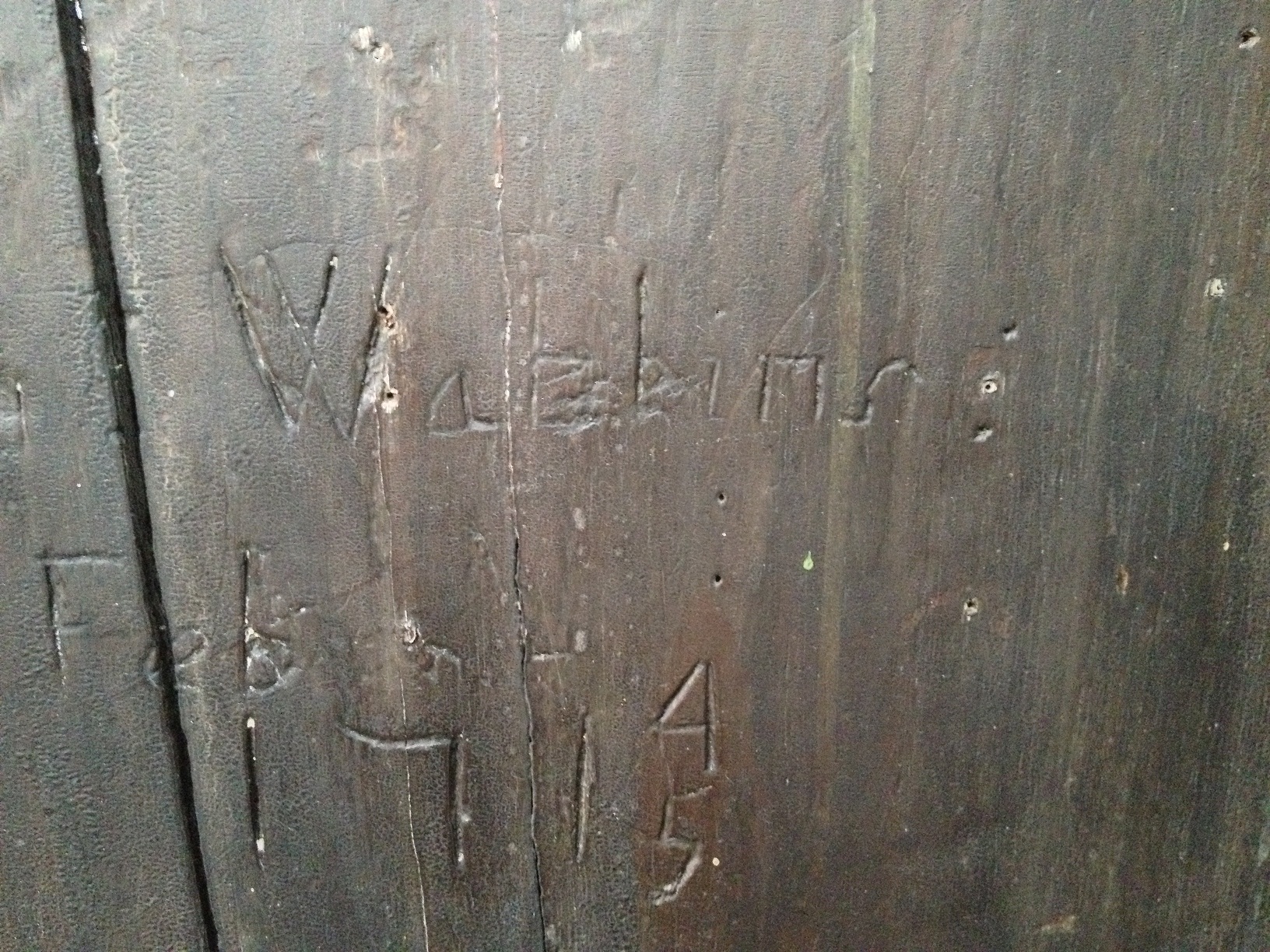
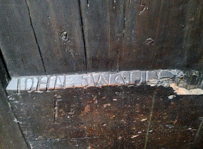
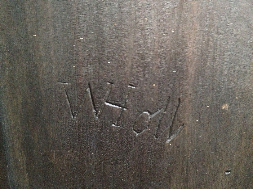
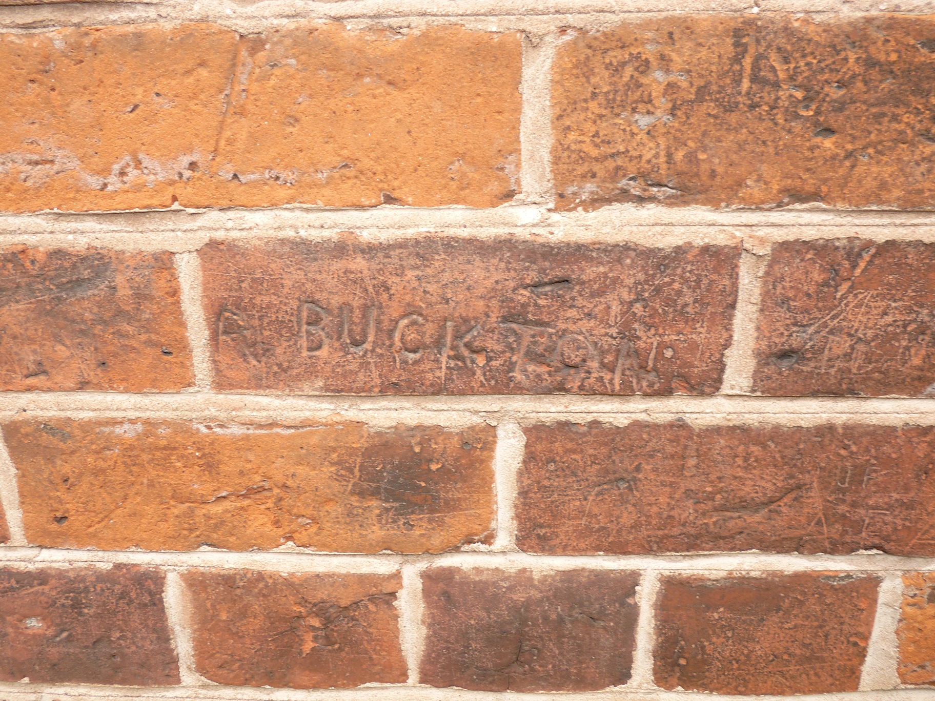
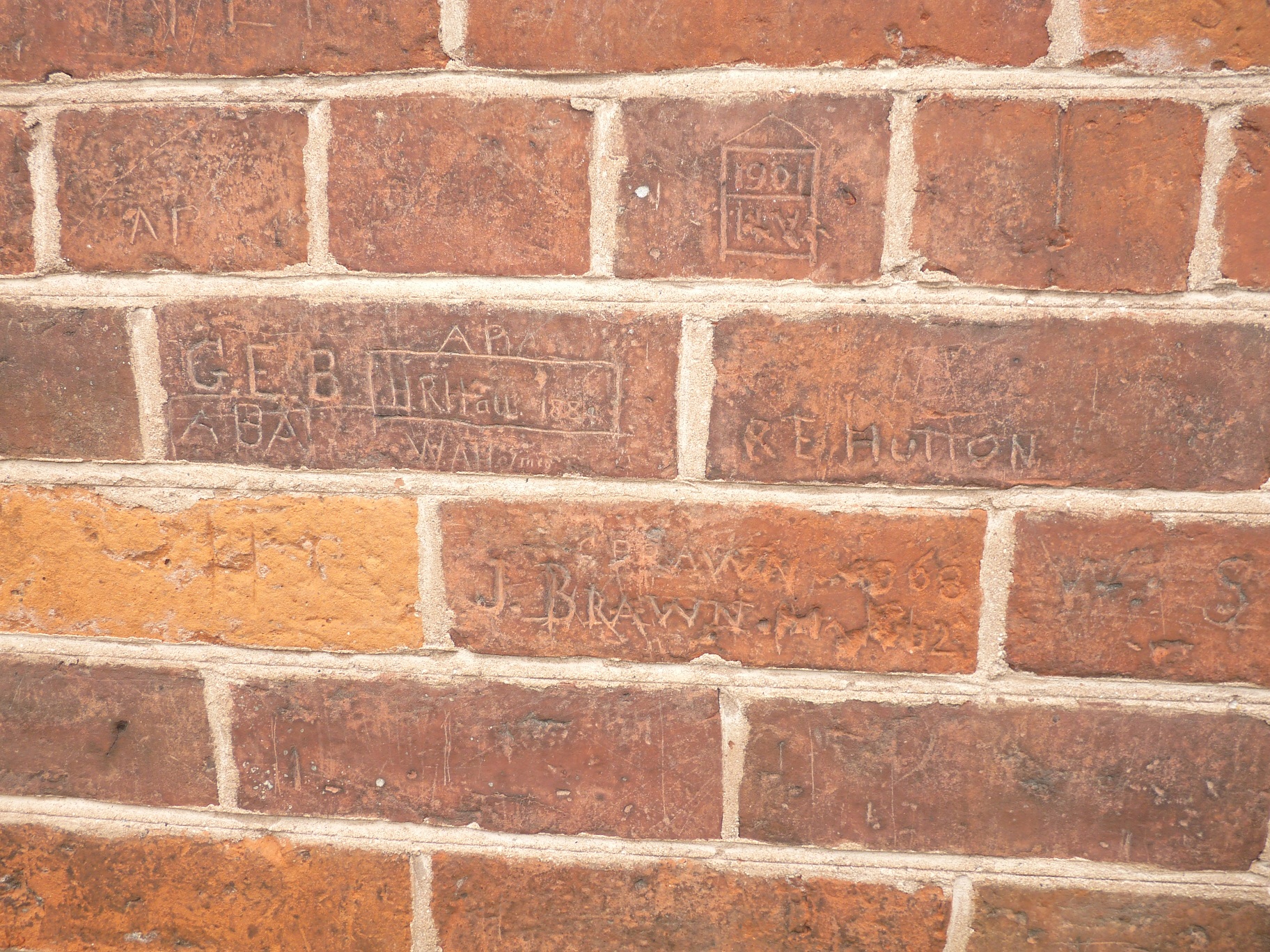
Following on from this morning’s post,  here is Gareth’s latest fantastic Lichfield Grammar School related discovery. The plaque suggests that this stonework was originally the front doorway to the Grammar School, and was redressed and placed around this doorway in the Lichfield District Council Offices in 1928. The second photograph shows our oldest dated graffiti yet – RS 1681.

As I’ve been reading about the school’s history, I’ve been jotting down the names of students. Here they are so far, in no particular order….some you may recognise, others you may not.

Isaac Hawkins Browne    Gregory King
John Wyatt                       George Smallridge
David Garrick                    Andrew Corbet
Thomas Newton                John Willes
Robert James                   Thomas Parker
Elias Ashmole                   William Talbot
Edmund Hector                William Noel
John Taylor                       Richard Lloyd
Charles Congreve            Samuel Johnson
William Wollaston            Theophilius Buckeridge Lowe
Francis Chetwynd            Joseph Addison
John Rowley                     Henry Salt
John Colson                     Joseph Simpson
Walter Bagot                    Charles Bagot
William Bailye

Do any of them match any of the initials found throughout the school? I have to say it’s the ones we don’t know much about that interest me the most. We all know what Mr Ashmole did, but what about those whose achievements weren’t documented to the same extent? What about those poor boys (with or without their brooms)? How did attending the school affect the course of their lives?

Image taken from Wikimedia Commons. Murray, John. Johnsoniana, 1835. reprinted Lane, Margaret (1975), Samuel Johnson & his World, p. 26. New York: Harpers & Row Publishers

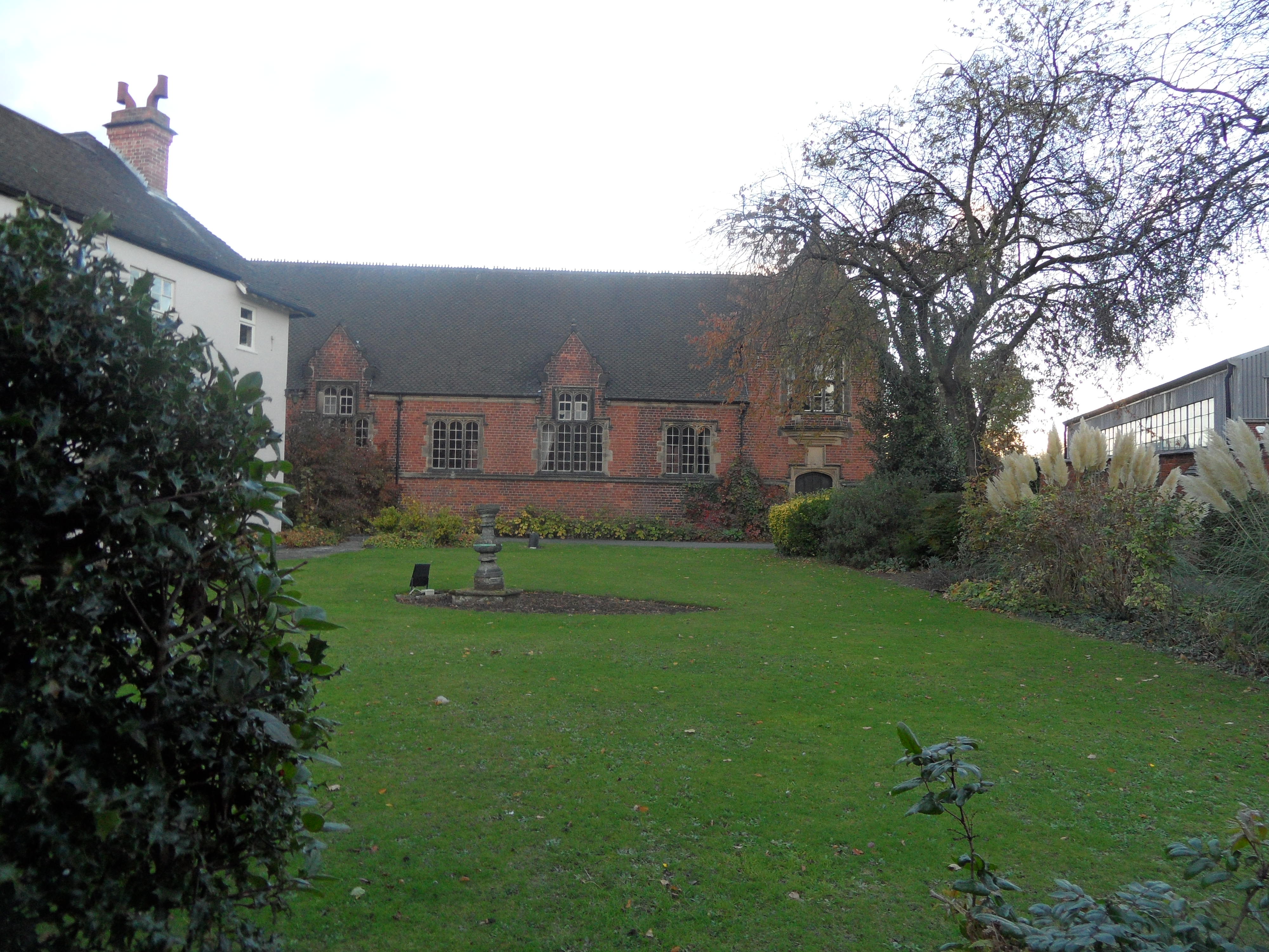
Several engravings and drawing of the Grammar School exist showing the schoolroom building at various stages in its history. Gareth is working on something that will hopefully show the changes in the schoolroom since it was first erected on the site in around 1577. This should hopefully help us to discover the original location of the stone doorway too.  The schoolroom was rebuilt in c.1848, and as the dates on the stonework are before and after this date, I wonder whether materials from the old schoolroom of 1577 were reused in carrying out this restoration work?  I’m hoping to go to the Lichfield Record Office as the National Archives catalogue is showing that the hold lots of information on this, and on may other aspects of the school’s history, dating back to around the same time RS carved his initials into the old doorway.

Finally (for now!), I’ve suggested that the doors of the Old Grammar School, both inside and out, be opened to the public for the Lichfield Heritage Weekend.

Update:

I found a book ‘The Wanderings of a Pen and Pencil’ from 1846, in which the authors FP Palmer and A Crowquill desribe their visit to Lichfield. Illustrations of the exterior and interior of the Grammar School are included in the book. Interestingly, their visit was at the time the school was in decline, and there were no pupils attending (see previous post).  They record that the upper schoolroom was tenanted by lumber, and the lower school room unoccupied, and asked ‘How is it the Lichfield Grammar School is so shamefully deserted and what amount is received by the master for doing nothing?’. In the interior, the stool that they have sketched was apparently the ‘flogging-horse’. The exterior drawing confuses me further – hopefully Gareth will be able to shed more light on how this compares with the other views of the schoolroom we have!.

Through Doors and Windows

Anyone who has read the Written into Lichfield History and Making your Mark posts, will know that Gareth Thomas has been exploring the Lichfield District Council Offices, and very kindly sharing the photos here on the blog.  Gareth’s doing this because the buildings were once the Lichfield Grammar School, and generations of pupils, dating back to the 17th century have left their mark on the building.

I like the idea that even those who didn’t go as far as leaving their name still left a trace on the worn bannisters and floorboards

Last time, we got as far as the attic doors, where someone called ‘Watkins’, carved his name in February 1714/5. Amongst the other graffiti is the name WHoll, and Roger Jones (Ziksby) put forward the idea that this could be William Holl the engraver, which certainly warrants further investigation.  Back then the doors would have lead to the dormitories for the boarders at the school. Now thanks to Gareth, we get to have a look at what lies behind those potentially three hundred year old doors……

Who was WL Holden? Does C1 refer to his form or something else?

To us these are old timber beams, yet once they were brand new, and according to the Lichfield Conduit Lands archives, mostly donated in the form of individual trees!


Gareth has taken some photographs from the windows. Not only does this give an interesting perspective of the city, it also invites you to imagine what the boys would have seen looking out of this window, what’s changed and what’s the same.

In around 1813, Cowperthwaite Smith was appointed headmaster of the school with a salary of £170 per annum, plus rent free accomodation. At the time, board, lodging & tuition was being charged at between 40 and 50 guineas a year for each scholar. In 1828, according to the ‘Account of Public Charities in England and Wales’, there were 18 boarders, and around 30-40 students in total. It goes on to say that the only scholars receiving their education free at the school were the ‘six children of poor men born within the City’ (who were also given money for books, and slightly more curiously brooms, when the school was first endowed).  The people of Lichfield were apparently not happy that their grammar school was no longer a free school.

By then end of Cowperthwaite Smith’s time as headmaster in the 1840s, no boys at all were coming to the school. Allegations were made in the Wolverhampton Chronicle that Lichfield Grammar School had been closed for six years due to the the misconduct of the master. It claimed he was violent towards the children in his care, and that ‘his treatment of two boys on two separate subjected his modes of punishment to investigation before the magistrates one boy having subsequently confined to his bed under surgical advice for a fortnight’.

The newpaper was sued for its attempt to injure Cowperthwaite’s ‘good name fame and credit’ as a schoolmaster and clergyman, and ‘to bring him into public scandal infamy and disgrace’ and ‘to hold him up to public contumely scorn and ridicule and to vex harass oppress impoverish and wholly ruin (him)’. I’m trying to piece together exactly what happened as best I can from the court cases that followed these allegations and I’m hoping that the original newspaper reports might be available. There’s also a vast amount of information at Lichfield Record Office that I’d like to look through, and I think it’s best not to speculate or comment further until I have read more on this.

I am also working on another post as Gareth’s investigations took him to another part of the building, where he made another fantastic discovery, including our oldest dated graffiti yet.  In the meantime, Gareth, do you fancy going up that ladder in the attic?

(1) A Concise Description of the Endowed Grammar Schools of England and Wales, Nicholas Carlise 1818

http://hansard.millbanksystems.com/commons/1846/apr/01/the-lichfield-grammar-school

http://www.lichfielddc.gov.uk/info/100004/council_and_democracy/588/history_of_district_council_house/2

http://eagle.cch.kcl.ac.uk:8080/cce/persons/DisplayPerson.jsp?PersonID=19831

Paths that Cross

On my way to pick up some tickets from the Garrick the other day, I passed Lichfield Library. I couldn’t resist popping in to have a quick peek at the local history section to see if they had any more information on the history on the grammar school,  following on from Gareth’s graffiti photographs.  (They did. A whole book in fact and I’ve updated the post accordingly!). So inevitably, my quick peek turned into two hours.

There was an added bonus to the visit too. Anyone who read my Cross City and Cross County posts will know that I was hoping there would be an ancient cross somewhere in Lichfield. Well, I finally found one! Actually that’s a fib. What I found is a photograph in a book of archaeologists finding one. A decorated cross shaft was discovered built into the foundations of the north wall of the nave of Lichfield Cathedral. It’s thought to be Saxon or Saxo-Norman, and could be a surviving remnant of the earlier church on the site. I wish I could share a photograph here, but all I can do is tell you that it’s on plate 1 in the ‘South Staffordshire Archaeological and Historical Society Transactions 1980-1981 Volume XXII’ book, on the local history shelves at the library!.

I have a confession to make. Generally, I’ve thought that places like the Cathedral are so well known, there’s nothing much left to say. Yet, now I recognise that this was wrong. Whether it’s the magnificent discovery of the Lichfield Angel in 2003, the downright curious tale of a live frog embedded in one of the stones used to repair the Cathedral during the restoration*, or rolls of parchment, beer and tobacco found in the gilded balls on the top of the central spire – the Cathedral, as everywhere, is made of stories, as much as it is made of stone. There are those we know well, those we don’t, and those that haven’t even been told yet.  We need to make sure we  are listening, just as Gareth was when he discovered and questioned that graffiti on the walls of the old Grammar school.

*I’m not making this up…..but someone else may well have been!

Making a Mark

I’m pleased to say that Gareth took my hint and very kindly sent me some great photographs of the names carved into old attic doors in the Lichfield District Council office building on St John St.  This part of the offices was the old school master’s house, dating back to 1682 and it’s thought the attic was used as a dormitory for boarders at the old grammar school.

One of the carvings seems to be dated 1715. If authentic, it means this door could be around 300 years old, possibly even original? Also there’s a rogue 4 nearby, is this a red herring or something to do with the change in calendar from Julian to Gregorian? This is about as clear as a pint of guinness to me, so any possible explanation would be welcomed!


Gareth also sent me a scan of a document – an indenture outlining the sale of the school buildings to Theophilus Basil Percy Levett, dated Christmas Eve 1902, and signed by the the school’s governors. It’s a fascinating document, there’s  information about the buildings,  the stamp of the Birmingham Paper and Parchment dealer, the seals and the names and professions of the governors (some are more familiar than others -Lonsdale, Cooper, Lomax, Ashmall and Andrews stand out for me).   In 1903 the school moved from St John St to Upper St John’s St, merging with Kingshill Secondary Modern in 1971, to form the present King Edward VI school.

Gareth’s photographs and images from the last few days are fascinating, but what I also think is interesting is the contrast.  The inky signatures of men who have already made their way in the world, compared with names carved into wood and brick by children starting out in life.  And what about the contrast of these grammar school boys with their peers?  Whilst they may or may not have gone on to fulfil their potential (see the comments on my previous post)  what of those other children that never even had the opportunity?

A couple of weeks ago, I was listening to the headteachers of our state secondary schools here in Lichfield talk about what their school offered to students. Each of them spoke convincingly about their commitment to giving each and every pupil in their care, regardless of ability or background, the opportunity to reach their potential in life.   I found myself moved by their words. This is how it should be.

Edit 2/11/2012

Yesterday at Lichfield Library, I found the book ‘A Short History of Lichfield Grammar School’ written by Percy Laithwaite in 1925. Mr Laithwaite refers to the graffiti, and I suspect this may be the original source (I found out about the existence of the graffiti on a Lichfield District Council document. I also saw it referenced in Howard Clayton’s Coaching City, whilst I was at the library yesterday). As well as providing small biographies of some of the masters and pupils of the school,  Mr Laithwaite also mentions that wooden panelling from the old school room is now used in the council offices, and that an oak desk from the school room was used as a locker at Bridgeman’s on Quonians Lane. If we could track that down, that’d be something!

Footnote:


I’m really pleased to say that Gareth Thomas who provided me with the graffiti photos and the indenture document, as well as other information over the last weeks has started his own blog http://lichfield.keepsblogging.com/ Gareth’s going to be sharing the things he discovers and judging by the gems he’s come up with so far, it’s going to a great read for those of us who enjoy exploring the history of this old city.

Sources:

http://www.lichfielddc.gov.uk/info/100004/council_and_democracy/588/history_of_district_council_house/2

http://www.kingedwardvi-lichfield.staffs.sch.uk/history.html

https://wiki.leeds.ac.uk/index.php/HIST2530_Building_the_literate_nation:_the_historical_debate#Literacy_Rates

Written into Lichfield history

One of my recent posts mentioned layers of history and people leaving their mark on a building.  A literal example of this is graffiti and Gareth Thomas has sent me some great photos of names he found carved into the brickwork of the Lichfield District Council offices, formerly the Lichfield Grammar School.

Lichfield District Council Building, formerly Lichfield Grammar School

The graffiti is on the above building, the old school room, rebuilt in the mid 1800s by architect Thomas Johnson, after falling into a ruinous state. Staffordshire Past Track has an engraving from 1833, taken from a similar position. It shows the previous incarnation of the school room (which stood from 1577 to 1849), as seen from the school-yard (now the grassed area).

In 1818, a book on the endowed grammar schools of England and Wales listed the former pupils of the grammar school ‘who in the splendour their names, have reflected honour upon Lichfield’.

The elegant Addison, Elias Ashmole the Philosopher Chemist and Antiquary and Founder of the valuable Musem called after his name at Oxford, Gregory King an heraldic and commercial writer, George Smallridge Bishop of Bristol, Thomas Newton Bishop of Bristol, Lord Chief Justice Willes, Lord Chief Baron Parker, Mr Justice Noel, Lord Chief Justice Wilmot, Sir Richard Lloyd Baron of the Exchequer, Robert James MD well known for his Medical Dictionary and as the inventor of the Fever Powder, Isaac Hawkins Browne an ingenious and elegant Poet, David Garrick the unrivalled actor, Samuel Johnson LL D

The names of Johnson, Ashmole and Garrick and the others are written into the history books, but what about those names on the old school wall? Can we find the stories of Buckton, Brawn, Beckwith and others written in censuses, newspaper reports and other archives? There’s an inspector’s report from 1869 that tells us something about how they’d have spent their time at school (when not carving their name into brickwork, of course!). What became of them when they left?

Brownhills Bob did a wonderful post on a similar theme called the Persistence of Memory, with some equally wonderful comments from people who recognised the names. You don’t have to look to hard to find bridges, walls, trees, and other surfaces marked with names and initials. Why do people seem compelled to add their names to the fabric of a place? I may even have written the odd ‘Kate was here’ myself, on a school desk or two in my time. And does that ‘….was here’ explain why we do it? Knowing that few of us will ever get a statue or our own museum, is this a way of letting people know that once, we were here?

A huge thank you to Gareth for the photographs and drawing my attention to this. Also, Gareth, if you’re reading this, I’ve read that there’s more graffiti to be found, carved into  the wooden attic doors of the schoolmaster’s house next door. It’d be great to see some photos…..hint, hint!

Sources

A Concise Description of the Endowed Grammar Schools of England and Wales, Nicholas Carlise 1818

Lichfield City Conservation Area Document


Tow Bone

As I’ve been telling anyone who’ll listen, I went to Manchester at the weekend. One of the highlights (or should that be lowlights?) was a tour beneath one of the city’s warehouses to see the remains of the Manchester and Salford Junction canal.

Standing in the canal! Tow path to the left.

I’m not going to say any more about it,  writing about a place 82 miles away is stretching it even for me (but for anyone interested, there’s some more of my photos and a bit about the  experience here). So, I’ll say a bit about the Lichfield canal instead…

I imagine most people know that there is an ongoing project being carried out by the Lichfield and Hatherton Canals Restoration Trust and you can read about and see photographs of the sections of the Lichfield Canal that are already under restoration on their website. A while ago, I was at the bridge on the London Rd, and decided to walk home following the route of the disappeared canal, down to Sandfields. I know there was a section of canal here, because I had read about it in a post Annette Rubery did about Sandfields Pumping station. Here are some photos of the walk, featuring one of my favourite things – bits of old brick hinting at a trace of something long gone!

I think somewhere around here was Gallows Wharf. The gallows were apparently located somewhere near to the Shell Garage on the London Rd.


The obvious route of the canal finished about here on Shortbutts Lane.

Then I mistakenly went up Fosseway instead of taking a right onto the Birmingham Rd and lost the canal route altogether but I did find a nice plaque!

Plus some interesting but I think non-canal related bricks at the junction of Fosseway and Shortbutts Lane with the Birmingham Rd.

I knew that if I got to Sandfields Pumping Station, I’d manage to pick the canal back up!

I noticed on an 1834 map of Lichfield that the canal in this area passed something called ‘The Bone House’. The county history says ‘There was a bonehouse evidently on the north side of the Wyrley and Essington Canal west of Chesterfield Road by 1806. The miller, Thomas Wood, was ordered that year to stop production following a complaint by the vicar of St. Mary’s that the works was ‘a noisome and offensive building and a great nuisance to the inhabitants of the city’. He was still in business in 1818 and the bonehouse remained there in 1836′.

I imagine it was used to grind down animal bones to make fertiliser, but if anyone knows any different, please let me know!

The idea of exploring the impact that the presence of water had on the surrounding landscape is something that really interests me. I think walking alongside our streams and canals, around our pools and millponds gives you the chance to look at a places from a different perspective. Next time though, I might take a map!

Sources:

Lichfield: Economic history’, A History of the County of Stafford: Volume 14: Lichfield(1990), pp. 109-131

Perspexive

This morning, I went to the dentist. On the way home I walked past St John’s Hospital. With the sun shining, I decided to pop in and allow myself a minute to take in the lovely surroundings and the calm atmosphere of the courtyard, before heading home.

At least that was my intention. As hospitable as ever, someone in the courtyard came over to welcome me, and invited me to have a look around the chapel. Never one to miss an opportunity to be nosey, I accepted with thanks.

I have been inside once before, but that visit was dominated by standing in front of John Piper’s striking window for the first time. Today, I sat on a back pew and found myself next to a perspex window. A small sticker told me that the stonework behind the perspex was the remains of a Norman water stoup. I understand that this would once have held holy water, into which those entering the chapel could dip their fingers, and make the sign of the cross. Apparently, many stoups were destroyed during the reformation but whether this is the case here I don’t know.  As the chapel has been heavily restored and altered over the centuries, I was delighted to have this chance encounter with part of the older fabric of the chapel.   Unfortunately, as I hadn’t anticipated there being many photo opportunities on a trip to the dentists, I had no camera. But the chapel is open everyday until 5pm, so if you can, please do go and take a look yourself, and enjoy visiting the grounds at the same time.

This got me thinking about the idea of layers of history within buildings, where generations of people have made their mark, by accident or by design, for better or for worse.  When I was volunteering at the Guildhall, someone told me I could get out using the back door. It was news to me that there was a back door but once through it, I made the even more exciting  discovery that  traces of the older building were still in evidence. For example, whilst the main hall and the front of the Guildhall date to the mid 1800s, the blocked window on the photograph below is thought to date to the 16thc.

Brickwork from different periods, round the back of the Guildhall

Another couple of examples to be going on with – what’s gone on here with all the different brickwork at this house in The Close?

This metal….thing, above a restaurant on Bird St, must have played some role in the building’s past, but what?

And when we’re talking about layers of history, should we also consider the present and future of buildings? I notice that the Angel Croft hotel has unsurprisingly made its annual appearance on the English Heritage At Risk register…..

Sources

http://www.british-history.ac.uk/report.aspx?compid=37864

An Overview of Lichfield

Gareth Thomas, from Lichfield District Council, has very kindly sent me some aerial photographs of Lichfield. Taken in 1963 and 1971, they provide a record of how the  city has developed and grown in the last 50 or so years (a quick look at the population figures shows that in 1961 the population was 14,090, growing to 22,660. In 2008 it was 30,583) (1)

Lichfield 10th June 1963

Lichfield 8th September 1971

Another aerial view of Lichfield taken 8th September 1971

One of the things I like about aerial photography is that it gives you a different perspective on places. A good example of this are the earthworks off Abnalls Lane, thought to be the remains of a medieval moated manor house, that I’ve mentioned before. At ground level you might well walk past, unaware of its existence. Look at it from above however, and you get a whole different impression of the site. What’s exciting for me (and yes, maybe I do need to get out more!), is that the aerial photograph that Gareth has sent seem to show more of the structure than can be seen on today’s aerial photos. To my untrained eye, back in the 1960s, it looks like the moat had some sort of channel running from it, and branching off into two.  Looking at the recent google earth maps, this part of the feature seems to have disappeared.

Crop of aerial photo taken 8th September 1971, to show Abnalls Lane area

Abnalls Lane Moated site circa 2010

View of the moated site from the ground,  August 2012

Massive thanks once again to Gareth. I’m really enjoying studying these photographs and I hope that others do too (On one occasion, I was so engrossed I forgot I was in 1971 not 2012 and was momentarily confused looking for the non-existent little yellow man to do a street view).  Gareth also has a great pinterest site here where he’s adding the local maps he discovers and there’s a great range on there covering different parts of the city & district, so once you’ve had your fill of photos, go and have a look!

Also, I should say that there are some posts & discussions on BrownhillsBob’s Brownhills Blog, based around aerial photographs of Chasewater, Shire Oak and Stonnall, also provided by Gareth.

(1) Source – Lichfield City Council http://www.lichfield.gov.uk/cc-statistics.ihtml

Potholes

After visiting the Christian Fields Local Nature Reserve, it seemed a good time to revisit the story that gave a name to the immediate area, and according to some, to the wider city as well.

Legend has it that in around 300AD, one thousand (or 999 depending on which version you read) Christians were massacred by a Roman army and their bodies left unburied in a place that would become known as the ‘Field of Corpses’ aka Lichfield (from the OE lic – body/corpse).   From 1548, versions of this story were depicted on the city seal, examples of which can still be seen in several places across the city, including the Martyrs Plaque at Beacon Park, 19thc police badges on display in the City Gaol, and in the main hall at the Guildhall.

Version of the City Seal from 1688, Main Hall, Guildhall

Several fairly obvious locations in the city have been mooted as possibilities for the specific location of the massacre, including Borrowcop Hill, St Michael’s Churchyard and the site of the Cathedral. However, what was it about this parcel of land, a mile north of the Cathedral that convinced people to such an extent, that it was given the name ‘Christian Fields’?

The image below is an aerial view of the area from 1971. Christian Fields is south of Eastern Avenue, between Dimbles Lane and Curborough Rd.  (Shortly afterwards, a new housing estate was built on the field. Perhaps as a nod to the site’s legendary history, the streets were named after saints. Funnily enough, one of these new houses was my husband’s childhood home – I must ask my in-laws if they ever found anything of interest in the garden!)

An aerial view of Christian Fields, 1971. Reproduced with thanks to Gareth Thomas, Lichfield District Council

Lichfield District Council’s information on the site says,

In the 17th-century the antiquarian Robert Plot declared that the area, now known as Christian Fields, had been the site of the martyrdom and it has born the name ever since. Needless to say Robert Plot’s claim has never been substantiated and no archaeological evidence has ever been presented in its support.

Looking at John Speed’s 1610 map of the city, I wonder whether the idea that the massacre took place at Christian Fields actually pre-dates Robert Plot? At the end of a road leading north from the Cathedral (possibly Dimbles Lane?), in the vicinity of Christian Fields, is an illustration depicting a scene that looks like a representation of the legend, similar to that found on the city seal.

John Speed’s 1610 map of Lichfield

In the early 1800s, local historians wrote about a series of discoveries near to the site, that persuaded them that the legend was true. The pastscape record has the following description, taken from a history book of the time,

In a meadow adjoining CHRISTIAN FIELDS, known by the name of the TOAD’S HOLE PIECE, have been recently found a considerable quantity of human bones, various pieces  of earthenware, some of which are Roman, a stone bowl or dish perhaps used for grinding corn, a stone ball, fragments of weapons including the head of a pike or halberd and several horseshoes  pierced for nails at the top as well as the sides. The objects  were discovered nearly four feet below the surface in a peaty soil, amongst and covered by great quantities of roots and decaying branches.

I found the book (1) on googlebooks and found it contained illustrations of the objects.


A letter to the Gentleman’s Magazine in November 1817 gave a little more information,

The articles of which I have sent you drawings were found near some land known by the singular names of Hic Filius and Christian’s field so called, according to tradition, from having been the place where the early converts to Christianity had used to assemble  and where the massacre from which Lichfield derives its name took place.

The letter goes on to describe what I think are these drawings from the Staffordshire Past Track site. – “a stone dish one foot diameter used perhaps for grinding was placed in the earth as a cover for a smooth red earthenware broken by the eagerness of the workmen to examine the contents (proved earth only). The black spots arc metallic. Also, the head of a weapon in preservation the wooden staff was broken off near the head, the iron is 21 inches in length.  There are also weapons found in 1817 in the foundation of one of the canons houses on the North side of the Close with some bones and broken armour”.

I’m not suggesting that the objects are proof of the legend, which along with the ‘Field of the Dead’ explanation of the place name of Lichfield is generally accepted to be untrue (the current favoured explanation of the name is ‘the common pasture in or beside the the grey wood).  However, and I may be reading into things too much here, I do think it’s a little curious that these items seem to almost be a tick list of props for the martyrs’ story…. Bones? Check. Horses & weapons? Check. A link to the Romans? Check.  The question I’m finding it hard to find an answer to is, if it’s agreed that these objects aren’t part of the story of the Christian Martyrs, in some way, shape or form, then whose story or stories are they part of?

Edit 6/10/2012

A further reference from the same book says the following,

About three quarters of a mile from (St Chad’s Well) are Hic filiius and Christians Fields where the converts of Ampbibalus are said to have been massacred; a considerable quantity of human bones have been found in the adjoining fields a few feet beneath the surface.

It has been the custom of civilized nations to collect and burn or bury the bodies of those slain in battle here fragments of bones are found scattered through a space exceeding half a mile and in one place only have they been met with under the appearance of having been buried which was in a field near Pones mill on the east side of the brook these had probably been dug up and thrown into an excavation as were several cart loads found in the field adjoining to that in which the earthen ware before noticed was discovered which were thrown into a marl pit near the spot. Tradition says the bodies of the massacred christians were left unburied a prey to the birds and beasts of the forest.

On maps from the later 1800s, there is a marl pit in the corner of the field marked as ‘Christian Fields’.

Sources

(1) A Short Account of the City and Close of Lichfield by Lomax, Woodhouse & Newling (1819)

(2) Derbyshire Record Office Online Catalogue

(3) Holinshed’s Chronicles ofEngland, Scotland & Ireland

http://www.english.ox.ac.uk/holinshed/index.php

http://www.british-history.ac.uk/report.aspx?compid=42340#s1


Hidden Depths

Circuit Brook marks part of the northern boundary of the city and runs through the Christian Fields Local Nature Reserve.  Last week I went for a walk to find the brook and found a whole lot more besides.

Despite the blue lines on the map, water was scarce, although some evidence of its presence lingered on in the channels it had forged over the centuries.

For much of the walk, we were separated from the route of the stream by steep embankments and rampant nettles, and at particularly challenging points, both!  Concerned about both the possibility of broken limbs and the availability of dock leaves, I didn’t stray far from the path, and used the zoom on my camera instead. Not very adventurous I know, but at least I lived to tell the tale!

Steeper than it looks! No, really it is!

Zoom.

Amidst the nettles is this green post. Any ideas?

A little way into the walk, watery looking plants and a visible outline convinced us that we’d found the site of the well marked on our Ordnance Survey map.

The smell of mint is what first alerted us to what we think is a well

At the point where we lost the route of the brook altogether we retraced our steps back and tried to pick it up again further upstream. This time the route took us along a flat, public footpath with woodland and fields to our left and the busy western bypass and underpasses to our right,  reminding us that we were right on the fringe of the city here.

Bypass underpass

A footbridge gave us easy access to the stream here, but once again it was dry.

Had we not turned back, we’d have found ourselves in Elmhurst.  What I hadn’t realised at the time was that part of the route apparently dates back to Saxon times, and incorporates an archaeological feature known as ‘The Dimble’. It’s great that the name is still evident in the area today. I’d like to find out more about this ancient walkway (the information I’ve included here is pretty much all I’ve been able to find so far), and also clarify exactly what  a ‘Dimble’ is, as I’ve seen a couple of different definitions.

I was also unaware until reading up on it, that the Christian Fields LNR was a landfill site until the 1980s when it was capped. Twenty or so years of allowing nature (and volunteers) to reclaim the site, has resulted in a place reclaimed for people to enjoy and explore. So go and enjoy & explore!

Notes:

Big thanks to Brownhills Bob for providing me with a map of the site and information about the nature of water, especially the advice to keep an eye on that well…..

Information on Christian Fields LNR taken from http://www.lichfielddc.gov.uk/info/200029/countryside/83/site_management/4