Something Old, Something Neo

At the end of the summer I went with friends to visit the Bridestones. Admittedly, this Neolithic burial chamber is a fair few miles from Lichfield and technically is not even in Staffordshire but definitely worth an excursion both in real life and also, I hope, via the blog.

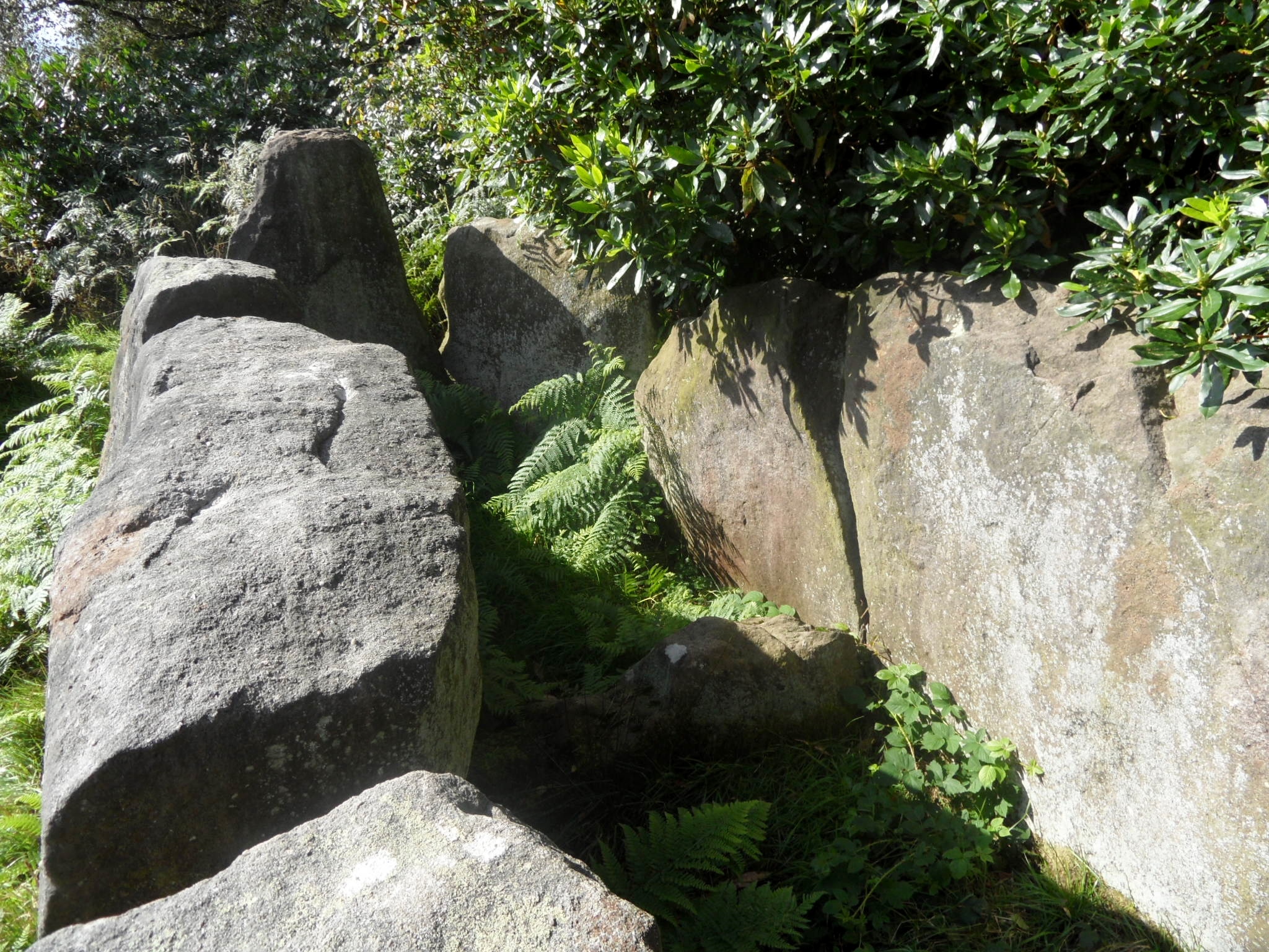
The Bridestones are thought to be somewhere between six thousand and four thousand years old. When you think that the estimate for the monument’s age alone covers a range of around two thousand years, you realise just how little we can be certain of and how vast the time scales are when it comes to ‘prehistory’. It’s an absolute wonder that these stones are still standing, and all the more remarkable when you read of their treatment in the past. Back in the eighteenth century, the site was regarded as a convenient quarry and was plundered for its stone, some of which was used to build local houses and some of which was taken to build the nearby toll road, as described in Henry Rowlands’ 1766 Mona Antiqua Restaurata

There was a large heap of stones that covered the whole an hundred and twenty yards long, and twelve yards broad These stones have been taken away from time to time by masons and other people for various purposes. And in the year 1764 several hundred loads were carried away for making a turnpike road about sixty yards from this place which laid it open for examination.


There are also rumours that some of the stone can be found in the ornamental gardens at Tunstall Park, which was opened to the public in June 1908. I’m a little sceptical about this but it does once again raise that interesting idea of recycling materials from older structures. The stones are said to have sustained yet more damage in the nineteenth century, both accidentally, when a fire lit at the site caused the stones to crack, and deliberately, when an engineer working on the Manchester Ship Canal supposedly demonstrated how detonation worked on one of the larger stones.

When trying to understand sites like the Bridestones, we look to archaeology to provide us with answers. The Stoke on Trent Museum Archaeological Society have a fascinating report on their website which contains drawings of what the Bridestones may have looked like back in the eighteenth century together with details of the archaeological investigations which have since taken place and what they can tell us about this ancient structure. You can read it here. However, as well as evidence provided by science, I also enjoy the folklore and myths that grow up around sites like the Bridestones. There are stories that they mark the resting place of a murdered pair of newly weds, a Saxon woman and her Viking groom. Others say weddings once took place here. Was the name ‘Bridestones’ given to the site to reflect these stories, or were they invented to explain an already existing name? I think it’s worth considering that stories were (and still are) ways of sharing and passing on information and that perhaps sometimes this information might yet be contained within such stories, however naive and implausible they seem upon first listen.

As I mentioned at the start, the Bridestones sit on the Staffordshire/Cheshire border, just inside the latter county. There’s a boundary stone very close by on the drive leading to the site and surely it was due to the presence of the Bridestones themselves that the border was established here in the first place, acting as a memorable boundary landmark. Why did our ancestors chose to erect their monument at this particular spot in the first place though?

Despite being ransacked and not looked after properly over the years, this is still an incredible place and you should definitely take the time to hop over the border and pay this old Cheshire couple a visit.

Holy Stones

Although St Peter’s Church at Elford was largely rebuilt in the nineteenth century, it is famous for its medieval monuments.  The most well known is the ‘Stanley Boy’, said to depict young John Stanley, last of the male line, holding a tennis ball in his left hand, and pointing to the place where it fatally hit him with his right. On face value, it’s a great story, but the fact that it has been cast into doubt by some makes it even more interesting in my opinion. Nikolaus Pevsner and an article called ‘The so-called Stanley boy monument at Elford’ by Sophie Oosterwijk for the Church Monument Society date the monument as thirteenth century whereas, according to the story, John Stanley died in around 1460. It has been suggested that at some point the effigy may have been modified to add weight to the local legend. It’s a nice reminder that when it comes to history, you can’t even trust what’s carved into stone. There’s a drawing of the effigy from the eighteenth century here on Staffordshire Past Track.

Unfortunately, on my recent visit, I didn’t manage to see the Stanley Boy (or whoever it may be!) close up. The wooden gates separating the Stanley Chapel from the rest of the church seemed to be locked and I didn’t try to hard to open them.  A lady doing her stint on the flower rota had told me that the church had suffered from a recent lead theft and I didn’t want to add to its troubles by breaking anything. Anyway, there were plenty of consolations including the beautiful Minton tiles, stained glass and another curious monument outside.

Just one of the lead pipes stolen for scrap metal, leaving the church vulnerable to water damage.

I’ve walked around my fair share of churchyards and although I’ve seen plenty of worn and weathered stones,  I can’t remember having ever seen a hole in one like this before and would be grateful for any explanations (or failing that, guesses!) for what’s happened here.

Forge and Ford

As the afternoon’s weather in Longdon was not quite warm enough for basking in the beer garden of the Swan with Two Necks, I took myself off for a little wander. The pub has a late 19th century map mounted on the wall, and it shows that the building next door was once a smithy. I’ve always had a soft spot for these simple buildings, softened even further by the discovery that one of my ancestors was an innkeeper with a sideline in blacksmithing. One of these days I’ll stop romanticising about it and actually get around to visiting Cirencester to see whether the forge is still there.  For now though, back to Longdon, where in May 1918, the then blacksmith, a Mr T Broadhurst had decided to give up the business and was selling the tools of his trade. On offer was a grindstone on a iron frame, two circular double blast bellows (nearly new), a treadle drilling machine, two black staple vices and other useful tools. The building remained a forge until 1938 and now is home to the WI.

Something else that appears on the pub’s map is a ford, which as the name suggests, is at the end of this lane. I had a walk down and within minutes found myself alongside the Shropshire Brook. I stood for a while on the little footbridge watching tiny yellow birds flit between the trees and the water’s edge. Interestingly, on earlier maps this seems to be called the How Brook.

Fords “shine in the memory” according to the writers of England in Particular

I don’t know much about fords, other than they are a way of crossing streams and rivers, presumably at their shallowest points. Whilst reading up on them at home, I came across a surprising account of an event that seems to have taken place here or very nearby (1).

Sir William Wolseley … lost his life about the beginning of the last century* in a very singular manner. He went to Lichfield one morning about nine miles from his house in his coach and four and on his way passed a little brook which runs across the road at Longdon and which is so shallow that a foot passenger can easily step over it the water being kept up by a mill dam at some distance from the road. When Sir William Wolseley reached this brook on his return home in the evening the mill dam just at that instant suddenly gave way the water rushed across the road overturned the carriage and drowned Sir William with his horses. The coachman was thrown off the box into a tree and escaped.

*July 8th 1728 according to the inscription on the monument to Sir William in Colwich church

Could this these gently flowing waters really have caused such devastation? It’s hard to imagine. A reminder, I suppose, that whether it’s the fire of the blacksmith, or the water turning the mill wheel, we can manipulate the elements of nature, but we are never fully in control.

Sources

(1) – A topographical and historical description of the Parish of Tixall in the County of Stafford, Sir Thomas Clifford and Arthur Clifford Esq, 1817.


Curiouser & Curiouser

On my work journey between Lichfield and Stafford, I used to drive past Wolseley Bridge twice a day, twice a week for two years, always curious about the collection of buildings and machinery opposite The Wolseley Centre and always meaning to return and take a proper look. Today I finally did!

The buildings house antiques, arts and craft businesses. Most are rescued relics from the our agricultural past – barns, stables and dovecotes. The main barn, facing the road, is thought to date back to the 17th century. It was taken down from Parchfield Farm in Colwich and re-erected here in 1985 and there’s a photograph here on Staffordshire Past Track of the work being carried out.

Side view of Parchfields Barn and Dovecote

Today I was lucky enough to see the re-construction of a timber framed building taking place for myself. Willey Barn came to Wolseley from Willey Lodge, in Presteigne, Powys in 1990. By 1993 one half of the barn, a three bay cart shed, had been rebuilt at Wolseley using traditional techniques but the second half, the granary, had remained in storage until now. There are some photographs of the barn in its original location on the planning application (details below).

Other buildings on site are the Moreton Stable and Cattle Shelter, the Ranton Barns, a Dovecote and an RAC callbox. Amidst the agricultural machinery is what looks like a small mine cart with part of a track and an old petrol pump (but please correct me if I’m wrong).  I think it’s fantastic that they have been preserved and given a new lease of life here and would really like to know more about their origins.

Incredibly, the biggest curio of the day for me was not found amongst this collection but up a track leading away from the craft complex and towards the Wolseley Park Estate.   I have plumbed both the depths of the internet and my imagination but as yet can’t find an explanation for this fenced-in stone structure. Does anyone else know anything?

Structure is to right of the track

Source:

Planning application: 12/16670/FUL | Extension to provide additional exhibition area | Willey Barn Wolseley Bridges Colwich Stafford Staffordshire ST17 0XS


Blue Sunday

My second ‘starting off at pub, and exploring the surrounding area’ type walk of the week, but this time with real life swans with just the one neck.

The sunny beer garden at the Red Lion was busy and I couldn’t help but feel that those who chose to remain inside the pub were missing out.  They were, and it wasn’t just the just the sun but also the wonderful sight of a pair of swans gliding down the canal with their eight cygnets. At one point the young ones were startled by a barking dog on one of the moored boats and darted back to huddle around one of their parents.

We began our walk by crossing the Lichfield Road Bridge (aka the Tummy Bridge in my house) to get to the towpath on the opposite side of the canal to the Red Lion. The next bridge along is the Hopwas School Bridge. As the name suggests it is near to the village school, named after founder Thomas Barnes. A lovely example of the local lad made good story, Thomas is said to have been abandoned as a baby, and discovered in a barn by villagers who gave him a surname to represent his humble beginnings. Educated and cared for by the villagers, Thomas became a successful London merchant. Had I walked a little to the right of the school, I would have seen the original schoolmaster’s house with a plaque reading ‘This house was built at the charge of Mr Thomas Barnes native of this place and a citizen of London in the year of our Lord 1717 for the dwelling of a person to teach the children of this village to read English’.

Instead, we kept on walking under the bridge and along the tow path. Something I did wonder about but couldn’t think of any explanation for at the time was the small door in the bridge itself. After doing a bit of post-walk googling it seems it might be a storage place for stop planks, used to block off part of the canal when maintenance work needs to be carried out. I think.

There was also some machinery on the other side of the tow path that looked interesting but again, I’m not quite sure of its purpose.

This, however, I did recognise to be one of the well documented pillboxes that stand in this area, defences against an invasion that thankfully never came.

Growing alongside the pillbox was a hint of what was to come in those infamous and ancient woods about which I’ve heard so much but seen so little, only ever passing by in the car. I’m pleased to say that Hopwas Woods lived up to my expectations, with a display of bluebells that put even my beloved Leomansley Wood in the shade. I attempted to capture it in photos, although they could never do it justice.

From then on I saw blue everywhere – the boats, the sky over the distant towers of Tamworth, a piece of pottery by the side of the canal and, after a big lunch and this short walk, a hammock at the water’s edge that looked very inviting indeed….


Watering Hole

On the way home from Tixall (of which more later), I stopped off at Longdon village and called into the Swan With Two Necks for a drink. I only had time for a very quick look around the village but even in this short space of time managed to find lots of interest, much of it water-related, which seems only natural in a place also known as Brook End. I hope to return to Longdon and the surrounding area (and of course the pub!) in the not too distant future. Amongst other things, I want to see if there are any nuggets of truth in an old ghost story I found about Lysways Hall….

The pub name Swan with Two Necks is apparently a distortion of ‘Swan with Two Nicks’, referring to the marks made on the birds’ beaks to denote ownership. More info here

Talking of ownership, the SWTN has been under the management of Mary McMeechan since 1st March 2013, the latest in a long line of landlords stretching back to 1755!

Brook End Mill dates back to the 1700s and appears on the Yates Map of Staffordshire.

The mill race still runs and you can follow it for a way up a public footpath.

This area is full of wells, some with brilliant names & legends attached. I think if I’d have carried on up past here, I’d have come to my all time favourite – Giddywell! Never mind, I did find this one near to the mill and there’s always next time…

I’m not sure if this pump is original. There are some other Staffordshire water pumps on this website, perhaps I should send them the photo and get their expert opinion?

These cottages are thought to be a 16th timber framed building that was divided up into separate houses at some point in the last half a millenium or so!

Over to the experts again, and this time John Higgins of the Mile Stone Society who researched Staffordshire Mileposts and found that in 1893, 335 posts were ordered from Tipton firm Charles Lathe & Co at a cost of 19s.6d each, including this one in St James’ Close

Familiar Looking

Always happy to be distracted from shopping, I had a wander down Quonians Lane to take a photo of a door (that’s a whole different post!).  Everyone loves Quonians Lane with its strange name and its carvings and plaques. Annette Rubery wrote a lovely piece about it back in May, which you can read here.  I love Quonians Lane too, although now my visits are tinged with sadness that the company, whose workers created these wonderful objects and many more across the city, the county and the country, is no more.

I saw the triangular roof of a small outbuilding above the brick wall and went to have a look, thinking it would be quite interesting in its own right. It was a lovely surprise to find these two marble statues stood in the doorways. If you want to see them for yourselves, go down Quonians Lane, and just after you get to the headless angel take a right, through the wall.

So the moral of this story once again is what I say in my ‘About Lichfield Lore‘ spiel.  “Go out and have a look at what’s around you. Then when you’ve done that, go back and have another look!”  I believe this more with each day I do this blog. I think that you can make new discoveries in the same place, depending on a whole range of things including the weather, your mood, what you’re thinking about at the time, the time of day or year or who you’re with. Actually I might change that to include having a smell/touch/listen too. Not sure about taste because I’m not sure I should be encouraging the kind of thing this young man got up to here…..

Anyway, today is a perfect day for me to bang on about this, as it’s the day we heard the news that around ninety further objects had been found at the Staffordshire Hoard site, three years after the original discovery was made. If that doesn’t convince you of the merits of having at least a second look, then I don’t know what will….


Potholes

After visiting the Christian Fields Local Nature Reserve, it seemed a good time to revisit the story that gave a name to the immediate area, and according to some, to the wider city as well.

Legend has it that in around 300AD, one thousand (or 999 depending on which version you read) Christians were massacred by a Roman army and their bodies left unburied in a place that would become known as the ‘Field of Corpses’ aka Lichfield (from the OE lic – body/corpse).   From 1548, versions of this story were depicted on the city seal, examples of which can still be seen in several places across the city, including the Martyrs Plaque at Beacon Park, 19thc police badges on display in the City Gaol, and in the main hall at the Guildhall.

Version of the City Seal from 1688, Main Hall, Guildhall

Several fairly obvious locations in the city have been mooted as possibilities for the specific location of the massacre, including Borrowcop Hill, St Michael’s Churchyard and the site of the Cathedral. However, what was it about this parcel of land, a mile north of the Cathedral that convinced people to such an extent, that it was given the name ‘Christian Fields’?

The image below is an aerial view of the area from 1971. Christian Fields is south of Eastern Avenue, between Dimbles Lane and Curborough Rd.  (Shortly afterwards, a new housing estate was built on the field. Perhaps as a nod to the site’s legendary history, the streets were named after saints. Funnily enough, one of these new houses was my husband’s childhood home – I must ask my in-laws if they ever found anything of interest in the garden!)

An aerial view of Christian Fields, 1971. Reproduced with thanks to Gareth Thomas, Lichfield District Council

Lichfield District Council’s information on the site says,

In the 17th-century the antiquarian Robert Plot declared that the area, now known as Christian Fields, had been the site of the martyrdom and it has born the name ever since. Needless to say Robert Plot’s claim has never been substantiated and no archaeological evidence has ever been presented in its support.

Looking at John Speed’s 1610 map of the city, I wonder whether the idea that the massacre took place at Christian Fields actually pre-dates Robert Plot? At the end of a road leading north from the Cathedral (possibly Dimbles Lane?), in the vicinity of Christian Fields, is an illustration depicting a scene that looks like a representation of the legend, similar to that found on the city seal.

John Speed’s 1610 map of Lichfield

In the early 1800s, local historians wrote about a series of discoveries near to the site, that persuaded them that the legend was true. The pastscape record has the following description, taken from a history book of the time,

In a meadow adjoining CHRISTIAN FIELDS, known by the name of the TOAD’S HOLE PIECE, have been recently found a considerable quantity of human bones, various pieces  of earthenware, some of which are Roman, a stone bowl or dish perhaps used for grinding corn, a stone ball, fragments of weapons including the head of a pike or halberd and several horseshoes  pierced for nails at the top as well as the sides. The objects  were discovered nearly four feet below the surface in a peaty soil, amongst and covered by great quantities of roots and decaying branches.

I found the book (1) on googlebooks and found it contained illustrations of the objects.


A letter to the Gentleman’s Magazine in November 1817 gave a little more information,

The articles of which I have sent you drawings were found near some land known by the singular names of Hic Filius and Christian’s field so called, according to tradition, from having been the place where the early converts to Christianity had used to assemble  and where the massacre from which Lichfield derives its name took place.

The letter goes on to describe what I think are these drawings from the Staffordshire Past Track site. – “a stone dish one foot diameter used perhaps for grinding was placed in the earth as a cover for a smooth red earthenware broken by the eagerness of the workmen to examine the contents (proved earth only). The black spots arc metallic. Also, the head of a weapon in preservation the wooden staff was broken off near the head, the iron is 21 inches in length.  There are also weapons found in 1817 in the foundation of one of the canons houses on the North side of the Close with some bones and broken armour”.

I’m not suggesting that the objects are proof of the legend, which along with the ‘Field of the Dead’ explanation of the place name of Lichfield is generally accepted to be untrue (the current favoured explanation of the name is ‘the common pasture in or beside the the grey wood).  However, and I may be reading into things too much here, I do think it’s a little curious that these items seem to almost be a tick list of props for the martyrs’ story…. Bones? Check. Horses & weapons? Check. A link to the Romans? Check.  The question I’m finding it hard to find an answer to is, if it’s agreed that these objects aren’t part of the story of the Christian Martyrs, in some way, shape or form, then whose story or stories are they part of?

Edit 6/10/2012

A further reference from the same book says the following,

About three quarters of a mile from (St Chad’s Well) are Hic filiius and Christians Fields where the converts of Ampbibalus are said to have been massacred; a considerable quantity of human bones have been found in the adjoining fields a few feet beneath the surface.

It has been the custom of civilized nations to collect and burn or bury the bodies of those slain in battle here fragments of bones are found scattered through a space exceeding half a mile and in one place only have they been met with under the appearance of having been buried which was in a field near Pones mill on the east side of the brook these had probably been dug up and thrown into an excavation as were several cart loads found in the field adjoining to that in which the earthen ware before noticed was discovered which were thrown into a marl pit near the spot. Tradition says the bodies of the massacred christians were left unburied a prey to the birds and beasts of the forest.

On maps from the later 1800s, there is a marl pit in the corner of the field marked as ‘Christian Fields’.

Sources

(1) A Short Account of the City and Close of Lichfield by Lomax, Woodhouse & Newling (1819)

(2) Derbyshire Record Office Online Catalogue

(3) Holinshed’s Chronicles ofEngland, Scotland & Ireland

http://www.english.ox.ac.uk/holinshed/index.php

http://www.british-history.ac.uk/report.aspx?compid=42340#s1


Hidden Depths

Circuit Brook marks part of the northern boundary of the city and runs through the Christian Fields Local Nature Reserve.  Last week I went for a walk to find the brook and found a whole lot more besides.

Despite the blue lines on the map, water was scarce, although some evidence of its presence lingered on in the channels it had forged over the centuries.

For much of the walk, we were separated from the route of the stream by steep embankments and rampant nettles, and at particularly challenging points, both!  Concerned about both the possibility of broken limbs and the availability of dock leaves, I didn’t stray far from the path, and used the zoom on my camera instead. Not very adventurous I know, but at least I lived to tell the tale!

Steeper than it looks! No, really it is!

Zoom.

Amidst the nettles is this green post. Any ideas?

A little way into the walk, watery looking plants and a visible outline convinced us that we’d found the site of the well marked on our Ordnance Survey map.

The smell of mint is what first alerted us to what we think is a well

At the point where we lost the route of the brook altogether we retraced our steps back and tried to pick it up again further upstream. This time the route took us along a flat, public footpath with woodland and fields to our left and the busy western bypass and underpasses to our right,  reminding us that we were right on the fringe of the city here.

Bypass underpass

A footbridge gave us easy access to the stream here, but once again it was dry.

Had we not turned back, we’d have found ourselves in Elmhurst.  What I hadn’t realised at the time was that part of the route apparently dates back to Saxon times, and incorporates an archaeological feature known as ‘The Dimble’. It’s great that the name is still evident in the area today. I’d like to find out more about this ancient walkway (the information I’ve included here is pretty much all I’ve been able to find so far), and also clarify exactly what  a ‘Dimble’ is, as I’ve seen a couple of different definitions.

I was also unaware until reading up on it, that the Christian Fields LNR was a landfill site until the 1980s when it was capped. Twenty or so years of allowing nature (and volunteers) to reclaim the site, has resulted in a place reclaimed for people to enjoy and explore. So go and enjoy & explore!

Notes:

Big thanks to Brownhills Bob for providing me with a map of the site and information about the nature of water, especially the advice to keep an eye on that well…..

Information on Christian Fields LNR taken from http://www.lichfielddc.gov.uk/info/200029/countryside/83/site_management/4

Sheriffs Ride…I walk!

I understand that for about 330 years, Lichfield was not just a city, it was a county, one of 18 towns and cities in England which gained county corporate  status at one time or another, for a variety of reasons e.g. Poole became a county separate to Dorset for reasons involving piracy! Lichfield’s status was granted by Mary I, apparently as a reward to the city for support during the Duke of Northumberland‘s rebellion.

A perambulation of the border of the city had been taking place since 1548, when Lichfield was made a city in Edward VI’s charter. However, that was carried out in view of the Sheriff of Staffordshire. Queen Mary’s charter, gave Lichfield the privilege of having its own Sheriff, who took over the perambulating duties and began the tradition of the Sheriff’s Ride which still takes place every September, on the Saturday nearest to the Nativity of the Blessed Mary. This year, it’s this Saturday (8th September).

According to the county history, the earliest records of Lichfield’s boundaries date back to the late 1700s (although older records of surrounding places indicate that changes in the borders have occurred over the years, particularly in the north and west). For those wondering, Lichfield is no longer a county, it reverted back to being part of Staffordshire in 1888.

Sheriff’s Ride, 1908. Taken from Lichfield DC flickr stream.

Thomas Harwood wrote in 1806,

The boundaries of the city of Lichfield according to ancient writings are a circuit of about sixteen miles.

Unfortunately, he doesn’t say where they are from, or just how ancient these writings are. However, it’s still interesting to read these ‘ancient writings’, not least because of the place names, familiar and not so that crop up along the route. (Some of the spellings are pretty interesting too!)

It begins at a place called the Cross and Hand near the end of a street there called Bacon street and from thence goeth northward along the lane leading to Longdon Church unto a little lane * at the further side of Oakenfields and so along that little cross lands unto another lane that leadeth from Lichfield to King’s Bromley and then along that lane towards Lichfield unto a little lane lying between the Grange Ground and Collin’s Hill Field commonly called the Circuit lane unto the further end of it betwixt two fields the one called Hic-filius and the other Piper’s Croft and so over across a lane that leadeth from Lichfield to Elmhurst and then into another little lane between Stichbrooke Ground and Gifforde’s Crofte and so along that little lane to a green lane at the further side of the Lady being the land of Zachary Babington Esquire and down that lane to a called Pone’s Brook and so over that brook into another lane called Stepping Stones lane and so along that lane taking in the land of Richard Dyott Esq Pone’s Fields unto a lane leading from Lichfield to Curborough Somerville so along that lane towards Lichfield until you come to the upper end of the grounds called Scott’s Orchard and then leaving that lane turn into a field of Lichfield called Whisich at a stilt going into the fields called Browne’s Fields and so taking in the field clled Whisich then go by the closes called Browne’s Fields Hedge unto the grounds called God’s Croft Hedge and so along that hedge taking in the field called Whisich lane called Goslinge’s lane and along Goslinge’s Lane unto a lane called Matthew Coal Lane and so over across that lane into a field called Cross field at or near an elm tree and so along a head land about the middle of Cressfield unto the nearer end of Gorsty Bank into the lane leading from Lichfield to a cross way called Burton turnings and from thence along Ikenield street taking in Spear Hill and Boley unto a cross way leading from Lichfield to Whittington and so along that lane towards Whittington unto the south end of Austin’s Coat Grounds then turning upon the left hand at that brook to a gate going into Fulfin Grounds unto the moors called Dernford Moors and so along by the hedge of those moors unto the nether side of Dernford Mill stream and so going by the mill door to the pool dam and going along by the pool and the brook taking in Horslade and a meadow belonging to Freeford House unto a bridge called Freeford Bridge in a lane leading from Lichfield to Tamworth and so from that bridge up the sandy lane to Freeford House and along that lane to the corner of the meadow and then turning into Bispells at the corner of the meadow and so going by the meadow hedge until you come to the brook that runneth to Freeford Bridge and so going up a little pool taking in all Bispells unto a ford called Baltrex ford and then entering into Old field turn up the left hand to the brook that runs from Freeford Pool and so along that brook to Freeford Pool and along by the pool and the brook that comes from Swynfen Mill until you come into the lane that leads from Swynfen unto the mill and so along that lane to a gate that leads from Lichfield unto Swynfen called Old Field Gate and then not coming in at that gate but going to the corner of the hedge adjoining to Cley Lands come in at a gap and taking in all Old field come by the demesnes of Swynfen unto a place called Long bridge and so entering into a little lane between Long furlong and Long bridge grounds leading to Well crofts and so taking in all Well crofts along by the Knowlc Leasowes being the Hospital Land unto Ikeneld street and so along Ikeneld street unto the further side of a close called Gorsty Leasowe and leaving the hedge on the left hand taking in that close going along by that hedge leading to Hare house Ground and so along that hedge unto the top of Dean’s Slade taking in all Hare house Ground northward enter into Park field leaving the hedge on the right hand and so following that hedge unto a little lane at Aldershawe that comes down that lane to the gate and through the gate then turn upon the left hand by Aldershawe Hedge taking in the barn and so go into the Wheat Close leaving the hedge on the left hand unto the road called the Fosse way up to the top of Mickle hill then crossing over Pipe green along an old decayed cart way into a lane end that leads to Pipe grange lane to the further side of Padwell’s and so taking in Padwell’s leaving the hedge on the left hand to a little lane that leadeth into Ashfield leaving the hedge on the left hand into the grounds called Lammas Grounds and leaving the hedge on the left hand and so into Lemondsley then following the brook to Pipe green gate and so along the brook in Pipe green into a little lane that butteth upon the lane that leadeth from Lichfield to Pipe and crossing that lane into Smithfield at the corner of Abnell Hedge and so taking in all Smithfield leaving Abnell Ground on the left hand unto the Cross and Hand where it began

*now Featherbed Lane

The ride now begins at the Guildhall, rather than Cross in Hand Lane but I’ve always thought it would be great to do the journey described above, looking out for the place names and landscape features mentioned (and potentially getting very lost, as some of them used in the directions may no longer exist!). As I don’t have a horse (my equine experience  consists only of  a few pony trekking expeditions, one of which ended in me being bitten by one in Cumbria), it’s a journey to make on foot, and probably in stages.  I have recently made a start but rather pathetically only got as far as Featherbed Lane. Only another 15 1/2 or so miles to go then. Just as well I’m not the Sheriff of Lichfield.

Cross in Hand Lane

Sources:

http://www.lichfield.gov.uk/events.ihtml

Lichfield: The place and street names, population and boundaries ‘, A History of the County of Stafford: Volume 14: Lichfield (1990), pp. 37-42. URL: http://www.british-history.ac.uk/report.aspx?compid=42340

The History & Antiquities of the Church & City of Lichfield, Thomas Harwood 1806