Hollow Earth

One of the most popular posts on the blog has been The Lichfield Underground. It seems people are fascinated by the unseen part of the city, the potential of what could be beneath their feet as they walk the streets.

Captivating, yet slightly scary….

It was this fascination with tales of the underground that started the chain of events culminating in the formation of Museufy, a group made up of myself and my friends Mark and Magdalena – two creative, innovative people that it’s a joy to collaborate with.  The aim of the group is to create alternative ways of collectively exploring history and interacting with our surroundings. We have a website where you can read our manifesto and find out about some of the projects we are working on.

One of these is ‘Hollow Earth Mapping’, a project in which we want to create a way to document underground spaces, mixing together reality and rumours.  We’re asking anyone who already contributed to The Lichfield Underground post via the comments section, or anyone else who has a story, to share them on our flickr page.  It will be a chance to look at  familiar surroundings through the fascinating, captivating and slightly scary world of the underground.

As the stories are shared, the underground spaces will be cut out, creating a hollow space on the map.   The flickr group will be a place for discussion about the stories, and the possibilities that might follow the creation of the map…..

Cross City

There’s some evidence that there were several stone crosses in Lichfield, although as far as I know, no physical remains have ever been found.

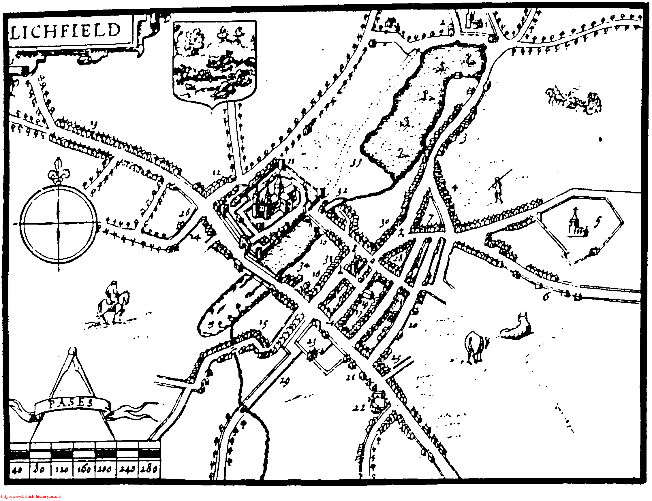
The most well documented of these is the market cross. According to the Lichfield volume of the History of the County of Stafford (1), a market cross stood north of St. Mary’s in the late Middle Ages and then some time around 1530, Dean Denton surrounded it with eight arches and added a roof  to keep the market traders dry. The building was topped with eight statues of apostles, two brass crucifixes on the east and west sides, and a bell, as you can see in this picture on the Staffordshire Past Track site.    The cross was destroyed in the civil war, and replaced with a market house, as shown in the illustration below (although it is referred to as a cross on the notes?) which has also now disappeared.

Taken from John Jackson’s book, History of the City and Cathedral of Lichfield, 1805

There is a possibility that there was a preaching cross in the grounds of St John’s Hospital as documentation shows that Dean FitzRalph preached outside in the cemetery. (2) Information on this specific example is really sketchy, but there is a surviving preaching cross in Bloxwich which you can read about in a great article on The Borough Blog.

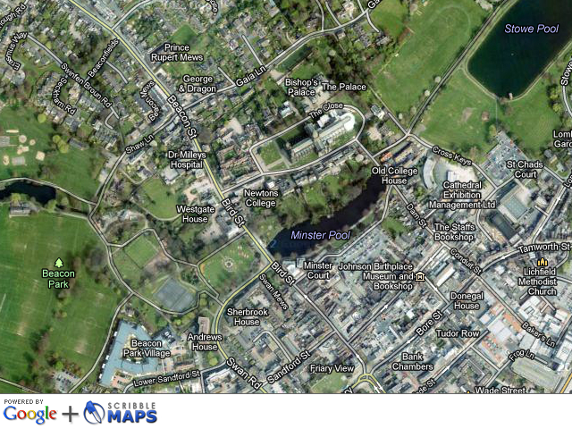
More evidence exists for a cross at the junction of Tamworth St and Lombard St. There is a cross like structure shown there on John Speed’s 1610 map, and in 1805 Thomas Harwood wrote that there was a stone cross in Tamworth St. (3) There are also a couple of references in old property deeds such as one from April 1316 describing a ½ burgage in street between the Stone Cross and Stow Gate.(4)

The Market Cross and the Stone Cross at Tamworth St can be seen depicted on John Speed’s 1610 map of Lichfield

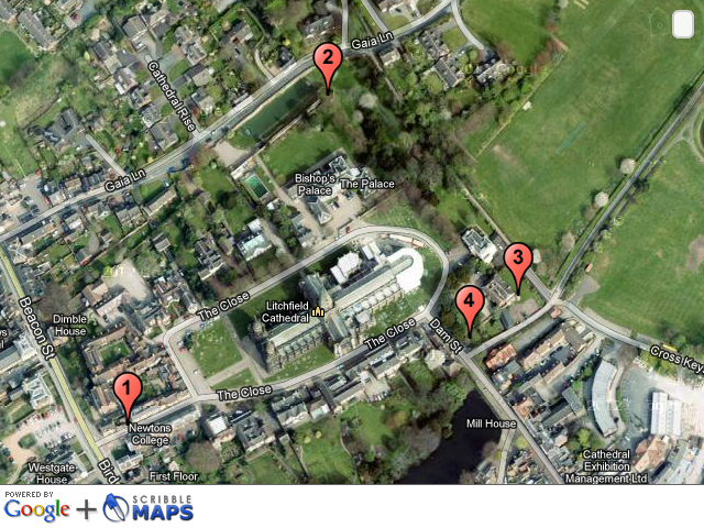
A cross apparently stood near Cross in Hand Lane in Lichfield, giving rise to a theory that it this is where the lane got its name from (the other theory is that is was a pilgrimage route, to St Chad’s shrine, where people would walk with ‘cross in hand’. The route has recently been incorporated into a new pilgrimage and heritage route called Two Saints Way). Harwood said,  “(Beacon Street) extends from the causeway over the Minster pool which separates it from Bird Street to houses at the extremity of the city called the Cross in the Hand and where stood an ancient cross ad finem villas.’ The pastscape record for the cross is here.

This week I came across another reference, this time Bacone’s Cross, and which was also thought to be in Beacon St, at the end of the town. Was the ancient cross at Cross in Hand Lane and Bacone’s Cross the same cross?

The Bacone’s Cross/The Cross in Hand and the Tamworth St cross were both situated at the ends of the town. Does this mean that they were boundary markers of some sort?  If so, could there have been more crosses marking other places on the City’s boundary.  There were city gates at both Beacon St and Tamworth St.  However, the probable sites of the gates don’t correspond exactly with the probable sites of the crosses e.g. the above example says ‘between the Stow Gate and the Stone Cross’.

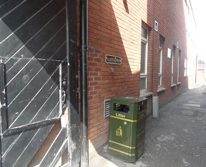
Tamworth Gate plaque on Lee Garden Chinese Restaurant Credit: Ell Brown (taken from flickr photostream).

In the absence of more information about Lichfield specifically, I looked elsewhere to see if crosses would have been used to mark boundaries. St Albans was surrounded by a ditch, like Lichfield (and there’s a link with the story of the  Christian martyrs but that’s a bit too much of a tangent for now!). The History of the County of Hertford, says this about the city’s boundary (5)

Crosses were at an early date erected at important points in the line of boundary, and at each of the entrances to the town, namely, the Stone Cross or North Gate Cross  at the north on the Sandridge Road, the Red Cross in Sopwell Lane, at the entrance by the old road from London, the Cross with the Hand in Eywood Lane, the Black Cross, probably at the angle where Tonmans Dike goes from the boundary of the houses in Fishpool Street towards the Claypits, and St. John’s Cross at an angle of the boundary in what is now known as Harley Street, but lately as Mud Lane.

It’s interesting to see that some of the names are the same – Stone Cross, Cross with the Hand – but I don’t want to start jumping to conclusions until there is much more evidence!

Finally, there is a document relating to property in Freeford (4), which describes ‘three selions of land at Lichfield, near Le Hedeless Cross, on the road towards Freeford’ in the time of Edward III – Henry V. Does this refer to the Tamworth St Stone Cross, or another cross altogether?

What happened to these crosses? Time? Religious differences? Where did they end up? There’s something in one of my all time favourites book that gives me hope (possibly misguided) that there is a chance, no matter how slim, that things that have long been thought to have vanished might turn up again one day in some form or another. In England in Particular (6), in the section on Wayside and Boundary Crosses, it says that,

Some crosses have been found in hedgebanks, with shafts used as gateposts. A number have been found by researching field names:two fields called Cross Park revealed previously undiscovered stones.

Fingers crossed!

Edit:

In view of the above, I thought it’d be worth having a look at field names etc, in Lichfield. There is an entry in an transcribed inventory relating to the real estate of the vicars that says Deanslade: Falseway to cross called Fanecross (4). There’s a Banecross on another transcription and I think one of these could be down to a typo and that they could be the same place, There is also an entry for a place known as Croscroft, which was on the road to Elford, near St Michael’s Churchyard (3)

Another edit:

I was hoping there would be an ancient cross somewhere in Lichfield. Well, I finally found one! Actually that’s a fib. What I found is a photograph in a book of archaeologists finding one. A decorated cross shaft was discovered built into the foundations of the north wall of the nave of Lichfield Cathedral. It’s thought to be Saxon or Saxo-Norman, and could be a surviving remnant of the earlier church on the site. I wish I could share a photograph here, but all I can do is tell you that it’s on plate 1 in the ‘South Staffordshire Archaeological and Historical Society Transactions 1980-1981 Volume XXII’ book, on the local history shelves at the library!.

Sources:

(1) Lichfield: Economic history’, A History of the County of Stafford: Volume 14: Lichfield(1990), pp. 109-131http://www.british-history.ac.uk/report.aspx?compid=42349#s6

(2) Hospitals: Lichfield, St John the Baptist’, A History of the County of Stafford: Volume 3(1970), pp. 279-289

(3) The history and antiquities of the church and city of Lichfield by Thomas Harwood

(4) Collections for a History of Staffordshire Part II- Vol VI (1886), William Salt Archaeological Society

(5)  ‘The city of St Albans: Introduction’, A History of the County of Hertford: volume 2 (1908), pp. 469-477

(6) England in Particular, Sue Clifford & Angela King for Common Ground

Bell-ow the Water

Water is in abundance at the moment, so Sandford Street seems quite an appropriate topic.   The street was once split into two parts -Sandford St and Sandford St, below the water. I believe that the latter is now known as Lower Sandford St, lay outside the city gate, and was once the main road to Walsall.

This plaque is near to the traffic lights on Swan Rd (confusing!) & the corner of Lower Sandford St


Hopefully, this will make more sense in conjunction with John Snape’s 1781 map.

John Snape 1781 map, taken from wikipedia

I’ve only just found out that around the same time as this map was made, an artist called John Glover painted a view of  Lichfield Cathedral from Sandford St. It’s in the Samuel Johnson Birthplace Museum and can be seen here.

The water in question seems to be Trunkfield Brook (formerly Sandford Brook) which still flows, with varying success, through the Festival Gardens. It’s thought that the name Sandford (earlier Sondeforde) might relate to a crossing over the brook, near to the gate. Apparently, a bridge was built there around 1520. I wonder if the brook was bigger in the past, as I’m pretty sure even I could jump over it. Almost.

Trunkfield Brook, often more mud than water.


In view of the above, I think that the symbol on the Sandford St below the water ward banner, as shown below, is pretty self explanatory.

More of a challenge to decipher is the banner for the other part of Sandford St (i.e the bit within the city). Why did they choose to represent this with a bell?

In the absence of anything I can find that links this part of Lichfield specifically to bells, so far all that I can think of is that it might relate to the iron & brass foundry set up in Sandford St in 1879. On an 1884 town plan, it’s shown behind the Queen’s Head. Although it was set up by a Yoxall based firm called Perkins & Sons, Tuke & Bell, who already had a foundry on Beacon St bought it in 1923 and renamed it the Lichfield Foundry Ltd. The Sandford Street works lasted right up until 1983, so there must be plenty who remember it, or even worked there.

On a street somewhere in Lichfield. I’ll be honest, I forgot to note down which one!

So, does this explain the bell? If so, it’s interesting that the foundry wasn’t in existence until 1879, and so the design on the ward banner is unlikely to date to before then. If not…..???

Sources:

‘Lichfield: Economic history’, A History of the County of Stafford: Volume 14: Lichfield (1990), pp. 109-131. URL: http://www.british-history.ac.uk/report.aspx?compid=42349&strquery=sand  Date accessed: 07 July 2012.

A short account of the city and close of Lichfield by Thomas George Lomax, John Chappel Woodhouse, William Newling

In defence of Lichfield

As I mentioned in the last post about the West Gate, some other remnants of the Close’s medieval defences are visible.  I’ve marked the ones I know about, on the map below, with a bit of information on each. I’m sure there’s probably more, and we could probably work out where the other defences were, but it’s a start!

1. Site of the West Gate – see previous post here

2. Remains of North East Tower & ditch. A scheduled monument, sometimes known as the Bishop’s Tower, this was part of the original, medieval bishop’s palace. The pastscape record can be seen here. A description of the tower and how it fitted into the rest of the palace can be found in several books on the Cathedral & Close (1) and is based on a plan that was held in the Bodleian Library (is it still there?). A plan drawn from this can also be found here.

At the north east corner was a tower fifty two feet high and each of its ten sides thirteen feet on the outside. It was called the bishop’s tower and the ruins yet remain. Adjoining this tower was a square room with stone stairs leading to the top on the north west of which was an apartment with a cellar underneath twenty two feet in breadth and sixty three feet in length. The bishop’s lodging room was forty feet by thirty two with a leaden roof and cellar underneath. On the north side of this room was a large chimney piece opposite to which a door led to the dining room sixty feet long and thirty broad. At the east end was a door opening into the second tower which consisted of five squares eleven feet in width and thirty two in height. There were two apartments each twenty feet by seven separated from each other by the large hall chimney, , the lady’s chamber…the brewhouse…and the kitchen.


 3. St Mary’s House. Incorporates a turret and part of the Close wall on the east and south side. Not only are there are arrow slits, but there are also rumours of a secret tunnel down below….Actually, it’s not that secret as loads of people seem to have heard about it.

 4. Remains of Eastern Tower of South East Gate. This description comes from the ‘Lichfield: The cathedral close’, A History of the County of Stafford: Volume 14: Lichfield

The gate built by Langton at the south-east corner of the Close had two towers. The eastern one, whose base was excavated in the late 1980s, was a half-octagon with 12-ft. sides. The western tower was presumably of similar dimension. The gate had a portcullis in 1376.  There was a drawbridge, still in existence in the earlier 18th century, which crossed the outflow of water from Minster Pool, and also a wicket for pedestrians. The gate was removed in the mid 18th century in order to improve access for coaches into the Close.


There’s also this bit of wall behind the Chapters coffee shop, which provoked a bit of discussion on Brownhills Bob’s Brownhills Blog, and with Annette Rubery. Especially about what that recess is!

While I was having a flick through googlebooks trying to find information on the subject, I came across an interesting snippet. Adrian Pettifer, in ‘English Castles: A County Guide’ makes the point that that unlike the majority of cathedral cities, there was no wall around the city of Lichfield as a whole.

So whilst the Close was protected by a strong wall, a ditch, 50ft towers, drawbridges and portcullises (when you put it like that it really does sound like a castle!), what did the rest of the city have? Well, there was a ditch. It’s thought even this was used more for controlling traders coming in and out of the city, than for defences. An archaeological dig carried out on the Lichfield District Council carpark in Frog Lane, also confirmed that the ditch was used as the city dump and found a variety of material, including it appears, the dog from Funnybones. There were gates too, the positions of which are still marked by plaques. Again, though it’s thought these might not have been defensive. I think the ditch and the gates deserve a post of their own, so I’ll come back to them another time.

Credit: Ell Brown (taken from flickr photostream)

This will also give me time to think about my latest question (one I’m sure has been thought about and answered by clever people already!). Was the city of Lichfield defended, along with the Close? And if not, then why not? Of course, if anyone has any ideas about this in the meantime, please let me know!

Footnootes:

(1) This particular description is taken from ‘A short account of the city and close of Lichfield by Thomas George Lomax, John Chappel Woodhouse, William Newling

(2) Thanks to this website http://gatehouse-gazetteer.info/English%20sites/3329.html for pointing me in the direction of some great links.

(3) I’ve also used this book From: ‘Lichfield: The cathedral close’, A History of the County of Stafford: Volume 14: Lichfield (1990)

What lies beneath Lichfield?

A very quick post to say that there is an archaeological investigation taking place at the Friary Outer car park. You can read a little more here at the project redevelopment website http://www2.lichfielddc.gov.uk/friaryouter/2012/05/02/friary-outer-archaeology-investigations/. It says they will be posting updates should anything be found.

I passed by last night and the dig has revealed what looks like the foundations of at least one building, including steps, a cellar and what could be a tiled floor.* I’m having a look at some old maps to see what used to occupy that site.

Unfortunately & unusally for me I didn’t have my camera or even my phone with me to take a photo. I’ll try and get one later but if you’ve got 10 minutes to spare on this dull bank holiday Monday, go and have a look and see it for yourself before it’s hidden from view once more. It’s intriguing to think how much history must lie beneath us, revealed to us from time to time by either by accident or design, or even nature (moles are particularly good at this apparently!)

* disclaimer – this is what it looked like to my untrained eyes. It could be something completely different!

Edit: Keep an eye on Annette Rubery’s blog as unlike me, Annette had the good sense to take a camera and will be posting some photos later! It’s here –  http://www.annetterubery.co.uk/

Edit part 2: This of course isn’t the first archaeological investigation in the Sandford St area. The Staffordshire Heritage gateway contains information about the previous discoveries near here for example,  a possible section of the ditch thought to have formed part of Lichfield’s medieval defences, remains of a house dating to around the C14th , tanning pits from the C16th to C17th, a possible post-medieval iron working complex and of course discoveries relating to the Friary complex.

Source:

Staffordshire Historic Environment Record, accessed via the Heritage Gateway


The Streets of Lichfield

It’s quite well known that Bishop Roger de Clinton laid out the main streets of Lichfield in a grid pattern, still in evidence over 800 years later.

Lichfield 2011-ish

What about those in between though? An email from Pat and a chance conversation about a book ‘A Walk Around the Snickelways of York’ by Mark W Jones (1) got me thinking about the alleys, the passageways, the shortcuts and the entries, winding themselves around buildings and connecting one Lichfield street with another.

Pat’s email asked if I knew anything about The Tanneries, running from Tamworth St, along the left handside of what was the old Kwiksave building, (and the Regal Cinema before that) to Cross Keys carpark.

The Tanneries

The Tanneries is blocked off at present

I don’t, but I’m interested how long this pathway and the others around the city have been around for.

Some are documented better than others. Friar’s Alley running alongside the edge of the site of the old Friary and onto Bird St appears as Friers Lane on John Speed’s 1610 map (no 29).

1610 map of Lichfield

Later it shows up on John Snape’s map as Friers Alley in 1781. On later maps, the narrow part leading to (or from depending which way you are going!) Bird St was known as Moss’s Entry.

Moss's Entry/Friars Alley onto Bird St

One of my favourites is the old carriageway leading to the courtyard of the George Hotel. It takes you past doors and bricked up windows, but it’s the floor with its Rowley Ragstone Setts (2) that I really like, as this small side passage gives an idea how Lichfield’s main streets would have been paved in the late 18th century.

George Hotel from Market St
 

I’ve taken some photos of others I came across. Most are found in the city centre though I’m sure there are loads more to be found throughout Lichfield. Of course, if anyone wants to share one they know of, or has any more information about any of the above or below, that’d be fantastic!


Bolt Court - a really busy little street


Inside Bolt Court


Alongside butcher shop on Market St


From Market St...


The Close to Erasmus Darwin House

Lloyds Walk


Tudor Row out onto Bore St

You see buildings differently walking these paths, maybe I’ll explore the backside of Lichfield a little more……

Footnotes:

(1)Snickelway is a great word created by Mark W Jones. It’s a portmanteau (which is in itself a great word!) of Snicket, Ginnel and Alleyway and Mr Jones explains, ‘A Snickelway is a narrow place to walk along, leading from somewhere to somewhere else, usually in a town or city, especially in the city of York’.

(2) Information taken from Staffordshire Pastrack website.

Map information from: ‘Lichfield: The place and street names, population and boundaries ‘, A History of the County of Stafford: Volume 14: Lichfield (1990), pp. 37-42. URL: http://www.british-history.ac.uk/report.aspx?compid=42340

Bricks & Water

With traces of snow on the ground, but the sun shining, I headed back to Farewell last weekend.  Following my previous visit, I’d had a look at some old maps and another extremely helpful conversation with BrownhillsBob on the subject of wells. I was hopeful that this time I’d be able to find the site of the well, that gave the place its name.

This description of the well is from ‘A Tale of Fairwell’, set at the priory in 1527 and published in the early 1800s  – ‘Exactly in the centre, the sparkling tide of a large well or rather fountain leapt from a carved stone basin and hurrying hither and thither amidst rich grass floated under an arch in the wall into the pool that supplied the mill.’ Whether there is any element of truth in this description or whether it’s completely imagined, I don’t know!

All I could find is this hollow, which is marked on maps ranging from 1884 to the late 1960s, as a pond. The maps also show a well or spring to the north east marked as ‘Well’ or ‘Fare Well’.

 Just down from this old pond, is a small brook in which there are some big chunks of stone. This brings me onto the next question! What remains of the priory of St Mary, initially founded as a hermitage but shortly afterwards converted into a nunnery?

The priory was dissolved in 1527. It seems that the old nunnery chapel was retained as a church but most of it was rebuilt in 1747 in brick,  leaving only the stone chancel.

The two different parts of the church.

Pat suggested that a nearby wall might contain some of the stone from the earlier building(s).

A brick wall has been built around the church yard, and this too seems to incorporate some older stone?

A archaeological resistivity survey carried out in 1992 located areas of higher resistivity thought to relate to demolition debris from structures associated with the church. Staffordshire Record Office hold the results of the survey which ‘revealed significant archaeological remains relating to the priory, including walls of buildings and the remains of the precinct wall’. I wonder whereabouts?

Until I can get my grubby mitts on a copy of this or any other real evidence, I’ll just have to be content that Farewell is a lovely place to speculate about!

Back to Black

After finding out about the Millenium Gates at Christ Church, created by contemporary Master Blacksmith, David Tucker, at his Derbyshire forge, I was interested to see if there was any trace of the many smithys and forges Lichfield once had. Using a town plan of Lichfield from 1884 & trade directories from the late 19th and early 20th century, I came up with a list of those whose location I thought I could roughly identify.

A weathervane I spotted on my travels

The locations are: Upper St John St;  Lombard St; Bakers Lane (3 in this area according to the map!) and Beacon St.

I headed to Lombard St first but it occured to me on the way over, I wasn’t sure exactly what I was looking for anyway? There might be some sort of clue I suppose, but surely there wouldn’t be a sign saying this used to be a forge…..

Well almost! Apparently, behind this facade is a building dating back to the late 17th century. To the right of the house is the workshop in the photo below – the listed building description describes it as ‘an interesting building where further investigation might reveal other early features’.

Workshop on Lombard St.

Before getting too carried away though, on the 1884 map of Lichfield, the smithy is shown on the other side of Lombard St. So this contradiction is a bit of a puzzle…. At home I tried to find out more – on the 1881 census for Lombard St is a Mr Joseph Baxter, blacksmith and his wife Catherine. On the 1896 directory, there is a Mrs J Baxter, blacksmith, Lombard St and the 1901 census seems to confirm that Catherine Baxter, now a fifty year old widow, took over her husband’s trade and was working as a shoeing smith, at 3 Lombard St.

1884 map indicated the Lombard St smithy may have been around here?

Next stop was Bakers Lane. I wasn’t holding out any hope for anything here but in the interests of a comprehensive search I had a look. Plus I needed some milk. As suspected, on face value there doesn’t appear to be much left of anything here.

So I headed for Upper St John St, where it looks as though a smithy (possibly listed to Fred Meacham in 1900) existed either alongside or within the Lichfield Brewery. I couldn’t find anything obvious here on the street, but later at home I did find a newspaper story telling how in July 1903, Mr Meacham, a blacksmith at the City Brewery had a terrible accident being run over by a horse float, after helping in a hayfield. Although Mr Meacham sustained a serious injury, the 1911 census shows that he did return to work as a blacksmith.

Whilst looking at the newspaper archive I found this notice taken out by William Goodwin in the Friday July 11 1902 edition of the Mercury. In it, he advised ‘Nobility, Gentry, Farmers & Others’, that he had taken over the blacksmith’s shop on Beacon St, lately occupied by George Goodwin.

Is there any physical trace of the forge on Beacon St though? Well yes and no. While nothing seems to remain of the building (as far as I could see), the road next to The Feathers pub is ‘Forge Lane’ and the road off this one is ‘Smithy Lane’.

 Footnotes!

In exploring this subject and related matters, I’ve had some great discussions with and help from BrownhillsBob so a big thank you to him.

Although I couldn’t see anything at some of the locations, that’s not to say there is nothing there…..

A few doors up from Catherine Baxter on Tamworth St, in 1881, another widow, Louisa Wood is listed as a ‘Plumber & Decorator’. Ann Tricklebank on Sandford St seems to take over her husband’s trade as a tin worker. I’d not ever thought about the role of women in these traditionally male trades before, so this is something I’d like to find out more about.

Even in 2007, the idea of a female blacksmith seemed to create much excitement in a national ‘newspaper’ with talk of ‘hot stuff’ and ‘unladylike professions’ and ‘an ancient art more traditionally associated with barrel-chested macho men’.

Almost 200 years ago, there are seven blacksmiths listed in the 1818 Lichfield Directory and by 1834 there were 10 – in Market St, Birmingham Rd, Sandford St & Tamworth St, as well as some of those mentioned above.

In surrounding areas there are of course also traces of blacksmiths. For example, in Burntwood there’s a Forge Lane, an Old Forge at Fisherwick, and an old smithy in Fradley. Even further afield, you can see some photos of Staffordshire smiths on the Staffs Past Track website.  

Using the town plan for Lichfield prompted me to see if there was one for Cirencester, where in the late 19th century, my g-g-g-grandfather ran a pub. I had read a while back that it’s no longer a pub so I had a quick look at it on the town plan to see where it would have been. Funnily enough, at the rear of the pub is a smithy and in the 1901 census my g-g-g-grandfather is listed as a Blacksmith & Innkeeper. Maybe that explains why I’m interested in blacksmiths and erm, pubs 😉

Update 19.2.202

Bob has very kindly put a post on his blog about the forge, with four great old maps of Lichfield. There are some great comments and based on these it looks as though the workshop was the smithy & the 1884 town plan may have it wrong. Also, you’ll see that Roger (@ziksby on twitter) has found 34 blacksmiths on the 1881 census. 34!

Sources:

Lichfield Mercury Archives

1884 Town Plan Lichfield

Staffordshire General & Commercial Directory 1818

Whites History, Gazeteer & Directory of Staffordshire `1834

Kellys Directory of Staffordshire 1896, 1900 & 1912

Wood Work

This week started with a brand new orchard and ended with an ancient woodland.

Last weekend, I helped to plant cider trees at Woodhouse Community Farm in Fisherwick. It wasn’t just the potential liquid reward that got me out of bed on a cold and frosty Sunday morning, there were a couple of other reasons!

It's got a lot of potential....


Orchards are becoming a rare habitat – according to Natural England, it’s estimated that the overall orchard area in England has declined by 63% since 1950. A traditional orchard can support around 1,800 species of wildlife. Although it will clearly take a while for the new cider orchard to reach this stage, I’m hoping that it will help to redress the balance a little bit! The People’s Trust for Endangered Species recently created an inventory of the traditional orchards in England, and you can read the summary of their findings for Staffordshire here.

Being involved with the orchard will also give me an opportunity to learn something about some disappearing traditional skills and knowhow. Growing fruit trees is a fascinating business, although I clearly have much to learn as I was the only person whose tree had to be dug up and replanted. Hopefully I’ll be better at the cider making bit, but if not, there’s always the cider drinking part which I’m fairly confident about.

In contrast to this budding orchard, on Friday I found myself amongst much older trees. Merrion’s Wood is a lovely nature reserve, just outside Walsall town centre and looked after by Walsall Countryside Services. Bluebells are already starting to shoot up all over there and countryside ranger Morgan told me that these plants were an indicator of ancient woodland, along with several other species.

Ancient Woodland in Leomansley

Leomansley Wood is full of bluebells in springtime. An interactive map of habitats from DEFRA confirms it as ‘ancient replanted woodland’. This means that although the site has been continuously wooded since 1600 (at least), the trees are more recent. It’s interesting that the place name is thought to include the celtic element ‘lemo’, meaning an elm (1) or possibly ‘leme’, lime tree.  The ‘-ley’ suffix is thought to come from the Anglo Saxon ‘leah’ meaning ‘clearing’ (2).

I think that to find a nearby semi natural ancient woodland, you need to visit Hopwas Woods near Whittington Barracks.  I should probably do this myself at some point! It’s worth pointing out that only 1.2% of the UK is made up of this kind of habitat and that it is irreplaceable. (3)

The DEFRA map also shows a traditional orchard between Maple Hayes and Jubilee Wood (where the conduits are!) with several others around Burntwood and Chorley. Perhaps even more interestingly, it seems there are two patches of traditional orchard in a built up residential area of Lichfield. I don’t know if I should say where, it might encourage scrumping!

I’ve also noticed several apple trees growing alongside the A51. How did these get here – discarded apple cores from car windows or remnants of something else? Perhaps more importantly, can I use these to make cider? 😉

Footnotes:

Don’t just take my work for how brilliant Woodhouse Community Farm is! There is a snowdrop walk on Sunday 5th February at 10.30am, where you can also see some of the things they have planned for the future.

The Woodland Trust point out that although many ancient woodlands have been recorded on inventories, there may also be unidentified fragments out there. Although bluebells don’t always indicate ancient woodland, if you do spot any growing this spring it might be worth having a closer look to see what else is around! The Woodland Trust have a really interesting guide to ancient woodland that you can read by clicking here.

Sources:

1) ‘Lichfield: The place and street names, population and boundaries ‘, A History of the County of Stafford: Volume 14: Lichfield (1990), pp. 37-42.
 2) http://finds.org.uk/staffshoardsymposium/papers/mattiasjacobsson

(3)http://jncc.defra.gov.uk/page-1437

Discovery Channel

After fifty-five weeks, four failed attempts and roping in several members of my family I finally found the medieval conduit head up at Pipe Hall Farm in Burntwood. You know though, you wait all year for a conduit head & then two turn up…..

A little background first. From 1160 until 1969 water was carried one and a half miles from springs in the Pipe area of Burntwood to the Cathedral Close via a conduit. At the source, a cistern was cut into the rock and a small brick building was erected over the source to keep the water clean and healthy. (2) This medieval conduit-head was in use for the majority of the time, but was temporarily replaced by a brick conduit between 1780 and 1821*. After an incredible 809 years, it was decided that it should carry water no more as it was constantly being damaged by ploughing and having to be fixed by Bridgeman’s employees (hope you appreciate the irony of this Vickie Sutton!) (3)

This pump outside the Cathedral replaced the Close’s conduit head in 1786

As water pipes go, this one had a pretty eventful life. Although the conduit itself was later known as Moses, it’s thought it gave the name ‘Pipe’ to the whole area.(4) It was vandalised by Lord & Lady Stanley, until King Henry VII stepped in in 1489 and told them to behave. In the early 16th century, washerwomen drawing water at the Cathedral end were said to be scandalising residents of the Close and during the Civil War it was inevitably stripped of lead by soldiers.(5)

In December 2010, around the same time I started this blog, I made it my mission to find the Medieval Conduit Head.  I went to the wrong woods twice. Then I went to the correct woods twice but looked in the wrong place. This time, I gathered a team of explorers aka my family and at the noticeboard in the Pipe Hall Farm car park I gave them their orders. ‘This’, I said pointing to a helpful map & photo, ‘is what we are looking for and we are not leaving here until we find it’. After an initial search proved fruitless we split up. Mr G spotted some bricks and on closer inspection we were sure we’d found the 18th century replacement brick conduit head.

Not medieval but still a conduit head!Close up there’s a visible date. 1755?

Cheered by this discovery, we went to find the others. My Mum wasn’t far away and told us a little further on she had spotted steps leading down to something and had sent my Dad to investigate. This had to be it.  I called to ask him if he’d found anything. ‘There’s this. I wasn’t sure if this was it or not?’ he said deadly serious, whilst stood next to a small building identical to the one in the photo.  ‘Yes Dad’, I said ‘Yes it is’. We celebrated with a cup of tea, enjoying the views of Lichfield from the hill.

The Medieval Conduit Head. As found by my Dad.


The channel making its way to the Close


…..to here.

Footnotes:

It seems ridiculous to say but both Conduit Heads are actually really easy to find. They are actually just off a main path running alongside the Jubilee Wood. You can even see the medieval one from this path.  => I was almost looking too hard. And I can’t read maps.

The Medieval Conduit Head was included on the 2008 English Heritage ‘At Risk’ register where its condition was said to be ‘poor’ but was removed from the list in 2010 after its restoration.

Pipe Hall Farm was recently included in the Guardian’s 10 best woods & forests for wheelchairs & buggies.

The date on the brick conduit head appears to be 1755, could this mean this conduit was in use for longer than previously thought?

I understand that the water that went to the other city wells & pumps (such as the Crucifix Conduit outside the Library and Records Office) came from a different source i.e. Aldershawe

Sources:
(1)Lichfield: Public services’, A History of the County of Stafford: Volume 14: Lichfield (1990), pp. 95-109. URL: http://www.british-history.ac.uk/report.aspx?compid=42348

(2)Water Technology in the Middle Ages: Cities, Monasteries & Waterworks after the Roman Empire by Roberta J Magnusson

(3) Annals of a Century: Bridgeman’s of Lichfield, 1878-1978 by Owen Keyte

(4) Notes on Staffordshire Placenames WH Duignan

(5) English Heritage at Risk Register 2008 and 2009