The traffic lights at Pipe Hill crossroads are haunted. Let’s just put that out there right away. Ever since this was pointed out to me by Deb from Melbourne in Lichfield, I’ve often found myself on red, sat waiting for something that I can’t see to pull out of Fosseway Lane. I’m imagining this spectral vehicle to be a Roman chariot because that’s the way to Wall and all of us good classical scholars know that ‘fosse’ is a Latin word meaning ditch. We also all know that ‘Caecilius est in horto‘ but we’re going up Pipehill not Up Pompeii.

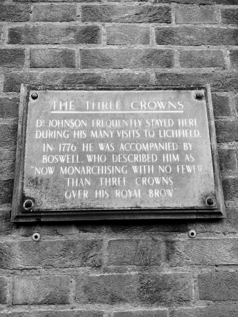
The Walsall Road was once owned by the Lichfield Turnpike Trust who had built a toll house and gate on it by 1787. In November 1879, the Trust held an auction at the Three Crowns inn, to dispose of them. The Victoria County History suggests the house was probably demolished by 1909, although the person who lives in it assures me that it probably wasn’t. The supposition most likely arises from a parish meeting at Hammerwich in 1909, where an old minute notebook from Pipe Hill parish (which by then had joined up with Wall) was produced, saying that the tollhouse had been sold to the Marquess of Anglesey on the condition it be taken down. At the time of the meeting the building was still standing but encroaching significantly on the footpath and the matter was referred to the overseers of Wall.
Further along towards Muckley Corner is Pipe Place, a mid-eighteenth century farm house. When owner Mr Bradburne was in horto he made a fascinating discovery that, like so much of our local Roman history, has never been acknowledged enough in meam humilem opinionem. As he was digging a drain, Bradburne discovered the trunks of several oak trees deliberately driven upright into the ground. Some had rotted away above the surface, but others were still whole, each with, ‘a cavity four inches wide and three inches wide from the top cut down its middle’. The structure was traced for about a quarter of a mile and was surrounded by a ‘fosse’ filled with peat.
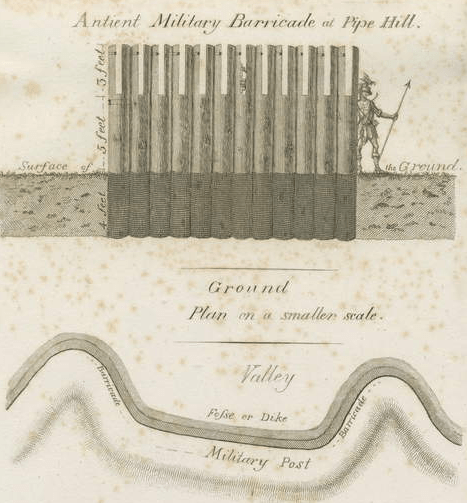
According to the Heritage Environment Record, this could still be seen as a linear feature on aerial photos in the 1990s but my amateur eyes can’t make anything out on Google maps. The Georgian gents who originally found it thought it must have been a military barricade erected by the Romans to defend Letocetum but more recently it has been suggested by archaeologist Jim Gould that it may have been an aqueduct built to provide the settlement with water. If you think about it logically, the water for that big bath at Wall must have come from somewhere. Two lengths of lead piping were discovered on the bath house site in 1874, last seen in the Lichfield Museum in 1961 but long since vanished with much else of the collection. In a later excavation, deer horns, a number of dogs’ skulls and the thigh bone of a teenage boy were discovered. Unfortunately, as yet I can’t find anything else about the context in which they were found although the pony skull discovered at the bottom of a nearby well may well have been a votive offering. It probably belongs to that one pulling that spectral chariot up at Pipe Hill cross roads.

Let us now gallop 1,500 years forward in time from possible pagan practices to Victorian values. The Misses Topham opened an establishment at Pipe Hill for young ladies in 1856 and I’m sure there were definitely some good classical scholars amongst them. In 1882, a tiny chapel was built at Pipe Hill, as a mission room to the church at Wall and during the First World War, a street shrine listing the names of those from the local community who were serving their country stood outside it. These shrines were different to the later memorials we are all familiar with in that they were as much about praying for the living as remembering the dead, and were often bestrewn with offerings of flowers, flags and photographs. Perhaps we didn’t come all that far from those pagan practices after all….The Pipe Hill Mission Church didn’t quite last a century and after laying disused for several years it was bought by Staffordshire County Council and demolished in 1971. One other institution which warrants a brief mention is the Pipe Hill and Farewell Association for Prosecuting Felons who advertised in the Staffordshire Advertiser in November 1817 a list of rewards they offered for the apprehension and conviction of those committing offences such as ‘highway robbery’ (£21), ‘wrongfully milking any cow’ (£5 5s) and ‘maliciously pulling up turnips’ (£2 2s).
Finally, how can I write about Pipe Hill and not mention Lichfield’s creepiest cottage? The property has been empty and decaying ever since I moved here in 2004, intriguing us all with its mysterious ‘Not for sale or rent’ notice. I drove past earlier and saw this is no longer the case. Much of the wilderness surrounding it had been cleared and for just under £300,000 cash, it can be yours. I strongly suspect the traffic lights won’t be the only thing changing at Pipe Hill in the near future…

Sources
Staffordshire Advertiser 29th November 1817 and 30th January 1915
Gould, J. (1998) Letocetum
Lichfield Mercury 31st October 1879 and 3rd November 1916
‘Townships: Wall with Pipehill’, in A History of the County of Stafford: Volume 14, Lichfield, ed. M W Greenslade (London, 1990), pp. 283-294. British History Online http://www.british-history.ac.uk/vch/staffs/vol14/pp283-294 [accessed 25 July 2021


 Lichfield Cathedral - Effigy of Captain Stanley: engravingShowing a print of the Stanley effigy. Anonymous.