Eilidh Armour-Brown

Leomansley House was once the home of the artist Eilidh Armour-Brown. She was chairman, treasurer and vice president of Lichfield Society of Artists and a founder member of Lichfield Arts Centre. Fans of ‘Who Do You Think You Are?’ will be interested to know that she was the great niece of Dr Thomas Barnardo. Eilidh and her husband Peter bought the house in the 1950s when it was three old mill cottages. Eilidh died in 1994 and there is a stone seat in the corner of Pipe Green Meadow, which reads ‘Peter Eilidh who loved this place’. I like to sit there and try and spot the deer at Maple Hayes through the fence. I love it too.


Some of Eilidh’s work can be found at http://www.search.staffspasttrack.org.uk

An interesting tidbit of info is that whilst renovations were taking place in 1956 an 11th century spear head was discovered by Master Derek Fearn.

Sources:
Lichfield in Old Photographs by Howard Clayton & Kathleen Simmons

Lichfield Record Office

Hollow Ways with Cross in Hand

Abnalls Lane

I first came across a description of Hollow Ways in the excellent book “England in Particular: A Celebration of the Commonplace, the Local, the Vernacular and the Distinctive”  by Sue Clifford and Angela King.

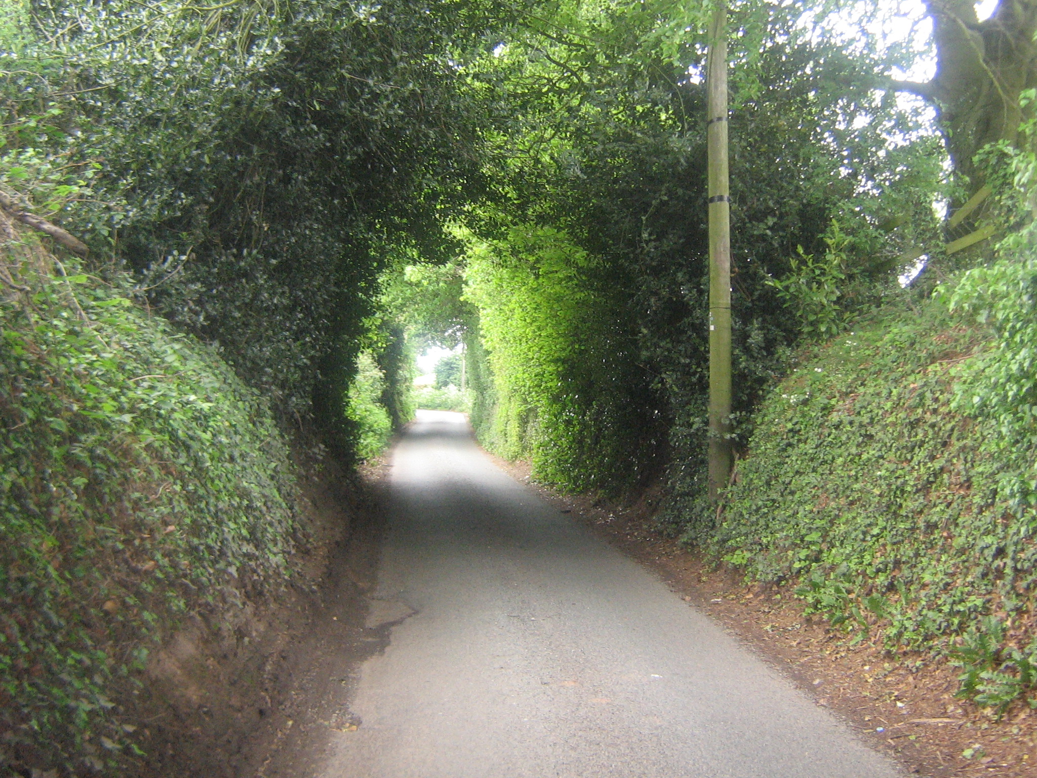
They describe Hollow Ways as “…those curious rural tracks that have been gradually ground out from hillsides by generations of pedestrians”.

As ever whilst looking for somthing else, I found out that there are several hollow ways nearby – leading East from Farewell, on the Parish boundary between Farewell and Chorley and Burntwood, Cross in Hand Lane and in the Maple Hayes area (Abnalls Lane) amongst others.

It seems from this description in ‘Lichfield: Domestic buildings and communications’, A History of the County of Stafford: Volume 14: Lichfield (1990) that Cross in Hand Lane was the road to Stafford until 1770.

“In the north of the city the road followed Beacon Street, described as the road to Stafford in the later 13th century, and Cross in Hand Lane. It branched off to follow the lane running along the north-west boundary which was still known as Old London Road in 1835. The cross with the hand which stood at the fork by the 15th century was probably a direction post. In 1770 the course of the road was straightened to avoid the hollow way in Cross in Hand Lane by means of a new line to the east, the present Stafford Road.”

There are records of a medieval cross between Beacon Street and Cross in Hand Lane, but no trace of this cross has been seen. I have seen two theories for the name Cross in Hand. Firstly, according to ‘Townships: Burntwood’, A History of the County of Stafford: Volume 14: Lichfield (1990), the area “..took its name from ‘the cross with the hand’ mentioned in the later 15th and early 16th century, evidently a direction post”. The Staffs Past Track website suggests this “The lane from Lichfield to Farewell, known as ‘Cross in Hand Lane’, is thought to be so-called because travellers wanting sanctuary at the Benedictine priory would use that route, carrying a cross in their hand”.

I have found a description of the Cross in Hand Hollow Way in ‘The Olio’ 1829.

“But the chief interest of the yew tree, in my eyes, is the mutual connection between it and some of the most stirring recollections of the past, and the most endearing circumstances of the present. How can I forget those twin Titans,superb in the blackness of their vivid foliage, that towered and waved over the red holloway near Lichfield! It was a little hamlet that, lying midway between the city and the old Benedictine Convent of Fairwell, was called Cross-in-hand, doubtless from the frequent monastic processions between the Nunnery and the Minster, or from some rustic image enshrined by the roadside.

The houses, nested under high banks, scarce revealed themselves by the smokewreathes among their orchards ; and the orchards themselves just raised their coloured raiment of blossom or fruit to a level with the smooth green uplands, which the holloway so deeply bisected. But the two yews, justly entitled Gog and Magog, upheaved their funereal forms and surgy branches into the free sky,— for miles the cynosure of this little caverned village”

I wonder if these two yews still exist. I’ll just add it to my ever growing list of things to go and have a look for!

Long Live the King's Head!

 A neighbour of the King’s Head has been complaining about the noise. Perhaps when they moved to the area they didn’t realise that there was a pub nearby – after all it has only been there since 1495. Anyway, for anyone who is interested in one of Lichfield’s oldest and most historic inns, here is a bit of history and legend.
According to the County History, The King’s Head in Bird Street was known as such by 1694 but in existence as the Antelope by 1495 and later called the Bush.


 On 25th March 1705 Colonel Luke Lillingston raised a regiment initially named ‘Lillingston’s Regiment’, then the ’38th of Foot’, and finally ‘The South Staffordshire Regiment’.  The 80th Regiment of Foot was raised in 1793 by Henry William Paget for the Revolutionary War with France and the original headquarters and place for enlistment was The King’s Head.

It is of course listed and the description given is ‘A coaching inn, now public house. Mid to late C18 with early C19 alterations. A good example of one of the coaching inns which served the London to Holyhead and Carlisle road’.

From the 1828-29 Pigotts Directory (as seen on the Burntwood Family History Group Website).

Coaches
TO LONDON the Herald (from Manchester) calls at the King’s Head every morning (Mondays excepted) at half past-two; goes thro’ Tamworth, Atherstone, Coventry, Daventry, Towcester, Stoney Stratford, Dunstable, St Albans Ec
TO MANCHESTER the Herald, (from London) calls at the King’s Head, every morning (Mondays excepted) at nine; goes thro’ Stone, Newcastle, Congleton Ec.
CARRIERS (i.e. freight)
TO BIRMINGHAM, Mrs. Bates, from the King’s Head,
TO BIRMINGHAM, UTTOXETER Ec.. Thomas Butler, from the King’s Head
The pub features on the Lichfield Ghost Walk. A maid is supposed to have died in a fire and a ghostly light is seen flickering in the upstairs windows. A mortally wounded laughing (!) cavalier wanders the pavement outside. According to the Staffordshire Encyclopedia there is also a ghost called George. On a personal note, I was sitting at a table with my family near the bar several years ago and I felt a sharp pain in my neck, as if someone had flicked it really hard and my necklace fell off. My neck had a big red mark on it and I’m still not quite sure what caused it!

Well, well, well! Merlich, Jacob & Mary


Most of us Lichfeldians know about St Chad’s well. However, I have come across a few other wells in Lichfield which seem to have disappeared.

Merliches Well – According to the William Salt Archaeological Society’s ‘Collection for a History of Staffordshire’, Merliches Well was on Merliches Lane, a short lane at right angles to Pipe Lane. Pipe Lane was the old name for Abnalls Lane and was on the east side of Beacon Street, or Bacone Street as it was known then.

From A Short Account of the Ancient and Modern State of the City and Close of Lichfield, ‘on the North Side of Shaw Lane leading to Merliche’s or Maudlin’s Well was a large house called Whitehall, and on the south side the Archdeacon of Chester had a house’. ( I think the Archdeacons house was on the corner of Beacon St and Shaw Lane).

John Jackson’s History of the City and Cathedral of Lichfield says that tradition suggests that Maudlins Well was so called due to a drunkard tumbling in one evening after one too many. However Jackson believes that the name instead referes to Magdalen.

Jacob’s Well – near Friar’s Alley, a few yards from the brook near this place was a spring formerly in repute for curing weak eyes and sores.

Marywell – In Breadmarket St, was a house called Priest’s Hall (now St Mary’s Chambers) and near here was a well called Marywell. According to the County History, St. Mary’s Well, in Breadmarket Street opposite the west end of St. Mary’s church, existed in the late Middle Ages

The Lichfield Gallows

A while ago someone told me that the Lichfield Gallows were situated near the Shell Garage on the London Road/Tamworth Road junction. A woman had told him she was walking past one evening and was pushed by unseen hands. Spooky!

I’ve always meant to check if this was correct and it appears that it is (the location that is, not the spooky story)!

Here’s a link to one of the oldest maps I know of – John Ogilby 1675 Lichfield to Chester  It’s fascinating in its own right, but for today’s purposes look at the bottom left corner and you’ll see Gallows marked, just outside of Lichfield.

‘The History of the County of Stafford: Volume 14’ tells us that ‘A gallows was built, or possibly repaired, at the bishop’s expense in 1532–3. In 1650 there was a gallows on the west side of the London road near its junction with Shortbutts Lane. The gallows there fell down c. 1700, its foundations undermined by people digging for sand, but it was re-erected’

In ‘Staffordshire Customs, Supersitions and Folklore (1924)’, Frederick Hackwood writes that at Gallows Wharf ‘half a centry ago a decayed oak stump stood two feet out of the ground….and was said to be the remains of the ancient gallows-tree’.

Given the description from the County History above, it seems unlikely that this is correct. However, it wouldn’t be the only one in the area – in Brereton (Brewerton?), near Rugeley, Mr Ogilby has marked ‘a hangmans oake on ye road’. A quick look at the archives does show a Hangman’s Croft in Brereton in the 1800s but at the moment I can’t find any other references.

JW Jackson, a City Librarian of Lichfield, contributed a local history column to the Lichfield Mercury in the 1930s. He carried out some research into crime and punishment in Lichfield and found that in 1711 the Sheriff of Lichfield was instructed to carry out two executions. One of these was a man condemned for murder. The other a woman who was sentenced to death for stealing a pair of shoes, a straw hat with brimming, a sixpenny loafe and a cheese. Presumably this poor woman fell foul of the 1699 Shoplifting Act which made it a capital offence to steal goods worth more than 5 shillings!

It seems public executions in Lichfield weren’t a common occurence. According to the website Capitalpunishmentuk, six executions were carried out in the City between 1735 and 1782.  Three men were hanged for uttering (which I understand is the crime of putting something forged into circulation) in April 1801 and the gallows was used for the last time on 1 June 1810 when three forgers were hanged. On the 1884 Ordnance Survey Map, the area is called Gallow’s Wharf, but by the 1920s it was known as St John’s Wharf.

Knaves Castle

One of the great thing about doing this blog is that whilst looking for one thing, you find ten other things! It’s amazing how many fascinating things are on your doorstep, or just down the A5 in this case. Until recently, I had never heard of Knaves Castle, but now that I have, I’m intrigued as to what this was. It seems that this question has puzzled people over the centuries.

Back in 1794, in ‘The History and Antiquities of Shenstone’, Rev Henry Sanders wrote that Dr Plot believed that Knaves Castle was a place to watch travellers safely cross ‘this heath, formerly all wood and much infested with robberies’…'(for) which the passengers allowed some small gratuity’.  In complete contrast, he reported that another of Dr Plot’s theories was that ‘the robbers themselves harboured in this place’ and hence the name Knaves Castle.  Rev Sanders’ own opinion is that ‘though there remain no signs of a fort, it seems very likely to have been one to guard strangers passing over so wild and dreary a country as Cannoc Wood is at present; much more was it such formerly, when full of woods and thickets’. I’m assuming that he is referring to Dr Robert Plot who wrote a ‘Natural History of Staffordshire’ in 1686 which included a map showing Knaves Castle (this can be seen on the Staffordshire Past Track website.

In 1870-72, John Marius Wilson’s Imperial Gazetteer of England and Wales, saysTraces of a Roman camp, called Knave’s Castle, are to the N of the village’ (the village referred to is Ogley Hay).

According to ‘Notes on Staffordshire Place Names’ by WH Duignan of Walsall, earthworks and tumuli are often called castles.  The book states that the tumulus is now almost obliterated and enclosed in a garden, but that sixty years ago was very plain (the book was written in 1902, so ’60 years ago’ would have been the 1840s).

Knave’s Castle is a kilometre west of the Staffordshire Hoard findsite, but Della Hooke from the University of Birmingham, in her paper ‘The Landscape of the Staffordshire Hoard’, casts doubt on the description of Knave’s Castle as a tumulus and believes that it is no more than a raised natural hillock.

The English Heritage description of the site can be at found at the Pastscape website.

Unfortunately, no there are no physical remains of  Knaves Castle.  Was it really a Roman earthwork, a hideout for robbers or just a hill?

Update: Since originally doing this post earlier this year, I have since come across an excellent and much more in depth post on Knaves Castle on The Gatehouse website.  The post concludes that Knaves Castle was an artificial earthwork, albeit one that may have developed from a natural feature.

Milling about in Leomansley

Leomansley grew up around the mill built by John Hartwell in 1791, on the edge of Pipe Green. Pipe Green was a meadow which had originally been left to the poor widows of Beacon St as pasture for their geese and was being used as common land.(1) As compensation for cutting a watercourse through the green, Hartwell made an agreement to give the poor inhabitants of Beacon St 10 shillings worth of bread each year.(2) Probably a lot of dough in those days….

Bullocks on Pipe Green


Anyone who has been for a walk over there will know that Pipe Green is home to around 12 bullocks.  I remember there being an advert in the Lichfield Mercury a few years ago, asking for someone to graze their herd there
. It’s still owned by Pipe Green Trust, which is made up of residents of Beacon St.

Back to the mill, and in 1841, the census shows several Leomansley residents working as wool combers or spinners. I’m wondering if the row of cottages on Christchurch between Leomansley Wood and the Old Vicarage (Easter Hill) were purpose built for the mill’s employees? It appears that some of these people moved on once the mill closed around 1860, as on the 1881 census, several of the properties in ‘Old Leomansley’ are listed as ‘uninhabited’.

On the subject of employment, the 1881 census also shows several men employed in railway related work. In fact men from three neighbouring households were all platelayers and there was also a signal man and a coal heaver in the area. I’ve found a great post about platelayers and what their work involved at turniprail.blogspot.com. Once again, I’m speculating, but I wonder if the Leomansley platelayers were responsible for the Sandfields stretch of track on the Lichfield to Walsall line, which opened in 1849 and would have been just across the fields (which are now the Darwin Park estate). There is a photo from 1924 of the track at Sandfields on the South Staffs Railway website as well as plenty of other fantastic photos and other interesting things!

Sources:

1) History of the Cathedral & City of Lichfield by John Jackson 2) A Short Account of the City and Close of Lichfield by Thomas George Lomax, John Chappel Woodhouse and William Newling 3) ‘Lichfield: Economic history’, A History of the County of Stafford: Volume 14:Lichfield (1990)

Pomology

Now, I know it’s not apple season, but I couldn’t wait until August!  I have found a couple of old books on the internet (thank you google books!) devoted to Pomology, in which each apple with its sometimes fabulous name, is described in a manner reminiscent of fine wines.

Listed amongst the hundreds of different varieties, such as Bigg’s Nonesuch, Poorman’s Profit and Cornish Aromatic  I found the Elford Pippin. Described as an excellent dessert apple, it was a round, medium sized fruit with yellowish green skin, with markings of russet on the shaded side and red stripes on the closest to the sun side. It had a yellow, tender, crisp flesh with a fine, brisk, sugary and vinous flavour.

The Pomological Society tells us “it was raised at Elford, near Lichfield, where it is a very popular variety, and to which locality it is at present chiefly confined”. As with so many tradtional varieties, it is no more.
Not only did Elford have its own variety of apple, it also had its own rhubarb – according to gardening tomes it was one of the most valuable varieties of rhubarb and was raised by Mr. William Buck, gardener to the Honourable Fulke Greville Howard, at the Elford estate. The green-fingered Mr Buck also grew a seedling grape (described as tolerably good), from seed sown in January 1821, and exhibited on the 1st of October 1822.
In the 19th century, in some parts of Lichfield, market gardening was a thriving industry. According to J Martin, Fisherwick Park gardens regularly sent cabbage, broccoli, asparagus and fruit to Birmingham and London in the early 1800s and the County History tells us that by the mid-century, there were 68 market gardeners in Lichfield delivering their produce by horse and cart to the neighbouring Black Country markets. I’ve been told that the land around the old City Brewery, and gardens on the Walsall Rd and Christchurch Lane were used for growing produce.
Green fields from Pipe Hill
Though it’s not famed for its fresh produce as somewhere like Evesham is (the fruit and vegetable basket of England, as their tourist office calls it!), there is still a fair bit grown in the Lichfield area. We’ve always been to Coulter Lane Fruit Farm for PYO berries and yesterday, I picked up my first fantastic vegetable box from the Woodhouse Community Farm scheme (which was part of the old Elford estate!). A few days ago I read on the Lichfield Blog that local growers won an award for their parsnips and the fields around Leomansley are full of potatoes and other crops.  I’m no evangelist about such matters but I do think we should try to support local food growers directly, so that neither they nor us are entirely dependent on supermarkets (though I do use them a fair bit). So go on, pop down to Coulter Lane & treat yourself to some strawberries, or order a box from Woodhouse farm.  Every little helps….
Sources:
The Apple and its Varieties by Robert Hogg, Vice-President of the British Pomological Society 1859
A Guide to the Orchard & Fruit Garden by George Lindley, John Lindley
The Social and Economic Origins of the Vale of Evesham Market Gardening Industry by J M MARTIN
An Encyclopedia of Gardening  by John Claudius Loudon
‘Lichfield: Economic history’, A History of the County of Stafford: Volume 14: Lichfield (1990),

Miss Seward's Prize Enigma

Anna Seward’s will, was said to have contained a riddle, with instructions to her executors to pay £50 to the first person to provide the correct solution. The enigma ended with the verse:

Now, if your nobler spirit can divine
A corresponding word for every line,
By all these letters clearly shall be shown,
An ancient City of no small renown.

In a compilation of Thomas Sedgwick Whalley’s Journals and Correspondence, there is a letter from Mrs Whalley, to her husband in 1816, enquiring whether he had been told the solution to the rebus by Miss Seward, as someone had managed to make the word ‘Litchfield’ but she had not heard whether the executors had agreed the claim. The editor of the compilation has added a footnote.  He asked a friend to find out more about the enigma. On January 31st 1863, the friend wrote to tell him that “ having been carefully through both the will and the codicils, which are very lengthy….there is nothing in either which in any way refers to “an enigma” which could be so construed”. Reuben Percy claimed the enigma was a shortened copy of a puzzle published in the Gentleman’s Magazine in March 1757, attributed to Lord Chesterfield. A solution offered by Solyman Brown was IEROSOLUMA, which I think is Greek name for Jerusalem.  You can find various versions of the enigma, and the solution, on Google Books. If, as it seems, The Swan of Lichfield’s will did not contain the ‘enigma’, it would be interesting to discover where the story originated.

Sources
Gleanings from the Harvest Fields of Literature – Charles Carroll Bombaugh Relics of Literature – Reuben PercyAn Essay on American Poetry – Solyman Brown
Journals & Correspondence – by Thomas Sedgwick Whalley, ed. Rev Hill Wickham

Kings of Lichfield

Borrowcop Gazebo
Down yon meridian fields afar
When Mercia led her chiefs to war,
Fell in one hour three monarchs brave,
And Lichfield’s bower protects their grave.
Her stately spires amidst the skies
Ting’d by the orient sun arise,
With golden vanes invite the gale,—
Triumphant ladies of the vale!
Extract from Needwood Forest by Francis Noel Clark Monday

Over the centuries, there has been a succession of structures on Borrowcop Hill.  There’s the (possible) Saxon Fort mentioned in my Lichfield Castle post; something called the Temple in the late 1600s; an arbour in the 1720s replaced by a summerhouse and finally the Gazebo that is still there today.  It was also the site of beacons, lit to warn of invasions. It’s hardly surprising given the views.

Lichfield tradition says Borrowcop is the final resting place of three Christian Kings, slain together with their outclassed army by the Romans in the time of the heathen Emperor Diocletian (around 288AD).  In John Jackson’s version of the legend, the bodies of the Kings were, “burnt and heaped upon a hill, according to the ancient custom of burial after a battle, and covered with a mound of earth, or tumulus, where, probably if dug into, the urns and ashes will be still discovered”.  However, a series of explorations have found no evidence of burials, although an anonymous source from 1819 is recorded as saying Erasmus Darwin recovered burnt fragments of bone from the site.
The legend gave rise to the theory that Lichfield meant ‘Field of the Dead’.  Perhaps being far more evocative than the currently accepted explanation for the name of ‘common pasture beside grey wood’, the ‘Field of the Dead’ theory still persists today.
Lichfield was incorporated by the protestant King Edward VI in 1548.  The following year, the city corporation chose to depict the ‘Martyrs’ legend on the city seal.  It’s been suggested that the corporation was keen to disassociate Lichfield from the Catholic connotations of St Chad. (The Victoria County History tells us that a previous seal is believed to have been a Bishop (presumably St Chad), with two angels either side and the Cathedral in the background).
You can still find the ‘Three Kings’ seal on the St John St railway bridge.  The legend is also portrayed on the the Martyrs Plaque, which originally adorned the front of the old Guildhall in 1707. The plaque was moved to a rockery in Beacon Park after the Guildhall’s victorian restoration.  After years of decay, the plaque was restored in 2010 and now stands in the Rose Gardens in Beacon Park.
St John’s railway bridge
Martyrs Plaque, Beacon Park (from Wikipedia)


Sources:
History of the City & Cathedral of Lichfield by John Jackson
English Heritage Past Scape
‘Lichfield: Town government’, A History of the County of Stafford: Volume 14: Lichfield (1990)
Public Sculpture of Staffordshire & the Black Country by George Thomas Noszlopy, Fiona Waterhouse

South Staffordshire Archaeological & History Society Transactions