Farewell Tour

From doing a bit of research on Cross in Hand Lane, I knew Farewell had been the site of Benedictine nunnery and also that the placename (sometimes spelt as ‘Fairwell’) refers to a nearby ‘fair or clear spring’. I had no idea what was left of either, the nunnery or the spring, so on the way home from Castle Ring, we stopped off for a look around.

St Bartholomew, Farewell

The most striking thing about the church is the mixture of  the two different building styles and materials. It seems the original church (which you can see here on the Staffordshire Past Track website) is thought to have contained parts of the nunnery which was dissoved in 1527.  Most of the old building was demolished & rebuilt in brick in 1745. However, the stone chancel remains. Below are a couple of photos  showing the contrast between the chancel and the rebuilt part of the church . I’m not sure but the bottom right corner of the older, stone built part of the building looks different again?

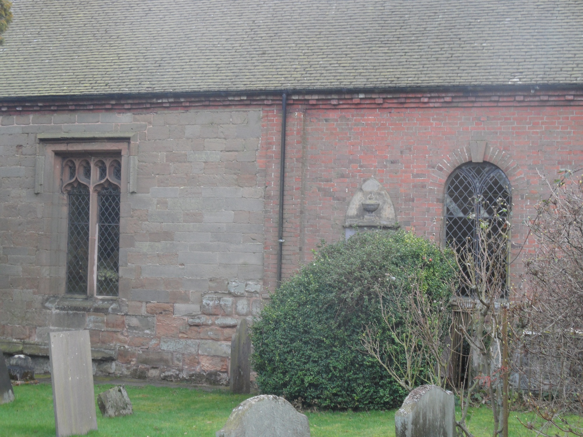
The two different parts of the church.

Have a look from a slightly different angle.

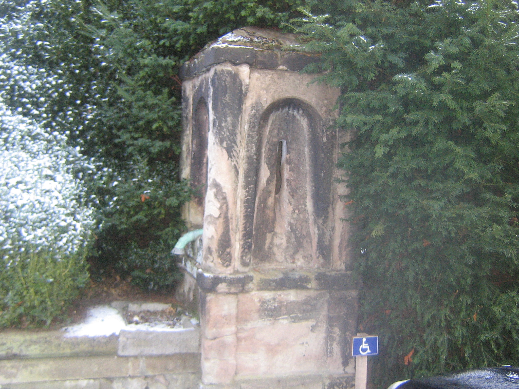
Whilst these renovations were being carried out, workman made a discovery. According to Richard Greene, in the south wall, six feet off the ground were three rows of earthen vessels. Each row contained vessels  of a different size (the smallest was 6 1/4 inches high) lying on their side, openings covered by a thin coat of plaster, facing towards to interior of the church.  All but three were broken in the process and one of them was kept at Richard Greene’s museum. You can see the picture here on the Staffs Pastrack website plus the letter written by Richard Greene to The Gentleman’s Magazine outlining the finds.

Initially, I found a couple of reference to the discovery of the Farewell Jars but no explanations or suggestions to why they were there.  Eventually, after a bit of searching, I came across a book on Church Lore (1), with a whole chapter devoted to ‘Acoustic Jars and Horses’ Skulls’ which specifically mentions the jars found at ‘Fairwell, Staffordshire’, describing how jars were used for enhancing the acoustics of a building. The idea is thought to date back to a Roman architect called Vitruvius. There are other examples of this idea throughout the country, and Europe, including St Andrews, Lyddington as below.

Acoustic jar in chancel wall, parish church of St. Andrews, Lyddington, Rutland 05/04/2009. Credit: Walwyn (taken from their Flickr photstream)

If you’re anything like me, you’ll be wondering what the ‘Horses’ Skulls’ element of the Church Lore chapter title was about. Apparently, animal skulls were also used to improve acoustics in a building and examples have been found in various places. Although this is fascinating, I’m not going to go into too much detail here as it isn’t directly related to Farewell. However, it is worth noting that there is some debate as to whether these skulls and to a lesser extent, the jars relate to something altogether different. Something along the lines of foundation sacrifices…

I’d love to know what others think about this and want to look more into this acoustic jar business. I’m also wondering where the rest of the nunnery, dedicated to St Mary, is ? I’m not saying farewell to Farewell, just yet….

Sources:
(1) Thomas Firminger Dyer Church Lore Gleanings, Chapter VII,

(2) Ralph Merryfield Folk-lore in London Archaeology Part 2, The Post Roman Period

Staffordshire Places website http://www.places.staffspasttrack.org.uk/

William Dugdale Monasticon Angelicanum

Scheduled Visit

Sitting in the car park of a closed museum*, we pondered our next move. I remembered there was a sign for ‘Castle Ring’ a little way down the road, an Iron Age Hill Fort I’d always meant to visit, but hadn’t. Perfect. A short while later we pulled up in a much fuller car park that the one we had left.

Plan B

Ridge & Furrow I think. See edit below.

As Castle Ring is only about 6 miles away from Lichfield, this post is a nudge to get you to go and have a look for yourself if you possibly can, as descriptions and photos (especially the kind I take!) are no substitute for visiting the highest point of Cannock Chase (235m in fact), which also happens to be a site thought to have been occupied 2,500 years ago. For more information & directions, you can download the leaflet from here and read a much more detailed description on the Pastscape record.

On the subject of photos though, it is worth having a look at a photo of the site from above.

Now that I’ve been once, I shall definitely have to go back. There are the remains of a 12th century medieval hunting lodge I missed and as well as being a Scheduled Ancient Monument, it’s also been classified as a Site of Biological Importance. Adders and common lizards, damselflies and dragonflies are found in the grass and bogland habitats there.

Obviously, I am no expert, but it’s interesting to read the Management Plan  produced by Cannock Chase District Council (according to the plan, they purchased the site for £200 in 1933 at a sale at the Swan Hotel in Lichfield. It had previously belonged to the 6th Marquis of Anglesey). It must be a hard task to maintain a balance between public access to somewhere like this and protecting the site’s ecology and archaeology. 

I’ve mentioned the Scheduled Ancient Monument we have here in Lichfield before. Other than this listing, is there anything in place to protect, manage or inform about this site, as there is at Castle Ring? Should there be?

*My fault entirely. Considering I spend so much time on the internet, you’d think I’d use it for useful things like checking opening times!

Edit 25/1/2012. Doubt has crept in about when that ridge & furrow dates to. I originally said it dated back to early 20th century, based on something I’d read but ‘Born a Lichfeldian’s’ comment has made me rethink this. So if any knows any better (and I’m sure there are plenty that do!) please don’t hesitate to put me straight!

Discovery Channel

After fifty-five weeks, four failed attempts and roping in several members of my family I finally found the medieval conduit head up at Pipe Hall Farm in Burntwood. You know though, you wait all year for a conduit head & then two turn up…..

A little background first. From 1160 until 1969 water was carried one and a half miles from springs in the Pipe area of Burntwood to the Cathedral Close via a conduit. At the source, a cistern was cut into the rock and a small brick building was erected over the source to keep the water clean and healthy. (2) This medieval conduit-head was in use for the majority of the time, but was temporarily replaced by a brick conduit between 1780 and 1821*. After an incredible 809 years, it was decided that it should carry water no more as it was constantly being damaged by ploughing and having to be fixed by Bridgeman’s employees (hope you appreciate the irony of this Vickie Sutton!) (3)

This pump outside the Cathedral replaced the Close’s conduit head in 1786

As water pipes go, this one had a pretty eventful life. Although the conduit itself was later known as Moses, it’s thought it gave the name ‘Pipe’ to the whole area.(4) It was vandalised by Lord & Lady Stanley, until King Henry VII stepped in in 1489 and told them to behave. In the early 16th century, washerwomen drawing water at the Cathedral end were said to be scandalising residents of the Close and during the Civil War it was inevitably stripped of lead by soldiers.(5)

In December 2010, around the same time I started this blog, I made it my mission to find the Medieval Conduit Head.  I went to the wrong woods twice. Then I went to the correct woods twice but looked in the wrong place. This time, I gathered a team of explorers aka my family and at the noticeboard in the Pipe Hall Farm car park I gave them their orders. ‘This’, I said pointing to a helpful map & photo, ‘is what we are looking for and we are not leaving here until we find it’. After an initial search proved fruitless we split up. Mr G spotted some bricks and on closer inspection we were sure we’d found the 18th century replacement brick conduit head.

Not medieval but still a conduit head!Close up there’s a visible date. 1755?

Cheered by this discovery, we went to find the others. My Mum wasn’t far away and told us a little further on she had spotted steps leading down to something and had sent my Dad to investigate. This had to be it.  I called to ask him if he’d found anything. ‘There’s this. I wasn’t sure if this was it or not?’ he said deadly serious, whilst stood next to a small building identical to the one in the photo.  ‘Yes Dad’, I said ‘Yes it is’. We celebrated with a cup of tea, enjoying the views of Lichfield from the hill.

The Medieval Conduit Head. As found by my Dad.


The channel making its way to the Close


…..to here.

Footnotes:

It seems ridiculous to say but both Conduit Heads are actually really easy to find. They are actually just off a main path running alongside the Jubilee Wood. You can even see the medieval one from this path.  => I was almost looking too hard. And I can’t read maps.

The Medieval Conduit Head was included on the 2008 English Heritage ‘At Risk’ register where its condition was said to be ‘poor’ but was removed from the list in 2010 after its restoration.

Pipe Hall Farm was recently included in the Guardian’s 10 best woods & forests for wheelchairs & buggies.

The date on the brick conduit head appears to be 1755, could this mean this conduit was in use for longer than previously thought?

I understand that the water that went to the other city wells & pumps (such as the Crucifix Conduit outside the Library and Records Office) came from a different source i.e. Aldershawe

Sources:
(1)Lichfield: Public services’, A History of the County of Stafford: Volume 14: Lichfield (1990), pp. 95-109. URL: http://www.british-history.ac.uk/report.aspx?compid=42348

(2)Water Technology in the Middle Ages: Cities, Monasteries & Waterworks after the Roman Empire by Roberta J Magnusson

(3) Annals of a Century: Bridgeman’s of Lichfield, 1878-1978 by Owen Keyte

(4) Notes on Staffordshire Placenames WH Duignan

(5) English Heritage at Risk Register 2008 and 2009