The Lichfield Underground

St Mary's House, The Close.

My introduction to Lichfield’s underground world came a couple of years ago, on the thoroughly enjoyable Gruesome & Ghostly City tour.

Then, back in January 2011, there was a series of great posts on TamworthTimeHikes about underground mysteries in Tamworth. As a result, information came to light (sorry!)about tunnels in Lichfield and Mark kindly passed the information on to me. Since then, tunnels have resurfaced several times (sorry again!), most recently in conversations with Vickie Sutton, Brownhills Bob , the folks at the BeaconStBlog, and as you may already have seen, in the comments section of the Monks Walk post. So, I thought I should finally get around to doing something on them! Here’s what I’ve heard/read/speculated about so far…..

1)      Under Sandford St

My first tunnel! Standing on the corner of Sandford St on a chilly October night we were told that tunnels led from that area to the Cathedral. In recent conversations on the Monks Walk post, ‘Born a Lichfeldian’ has contributed more to the story of the tunnel, suggesting that the tunnel also runs to The Friary.  You can read the discussion here.

2)      White Hall on Beacon St

In a book ‘Lichfield & its Cathedral’ by H Snowden Ward (1893) is the following description “From the cellars of the inn, an underground passage ran some distance and was popularly believed to terminate as St Chad’s Church. That is went so far is extremely unlikely, and what was its object or termination will never be known, for a few years ago the late owner of the White Hall caused the portion under that house to be filled up, and without having the passage explored through its whole length”.

Edit 15/11/2011

City librarian & historian J W Jackson (who I’ll introduce you properly to another time) noted in his weekly history column in the Lichfield Mercury of the 1930s that the tunnel under White Hall was dug out by a previous owner during the plague. Presumably he wished to go about his business without soming into contact with carriers of the disease or the bad air that some thought caused the plague at the time. Would be interesting to see if there are stories of any tunnels elsewhere being dug for this purpose?
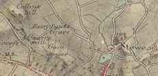
3)      Under Dam St

Some information from googling,  that I think came may have originally come from the Staffs Books Shop that used to be on Dam St, says that there is speculation that a passage runs along Dam St from the Cathedral to the Guildhall, and was used as an escape route during the Civil War. In an 1819 book, ‘A Short Account of the Ancient & Modern State of the City & Close of Lichfield’, it says ‘A large subterraneous passage of stone, several feet beneath the surface, has been traced from the middle of Quonians Lane, under the houses on the west side of the street, for a considerable distance in the gardens; its use cannot now be ascertained.”

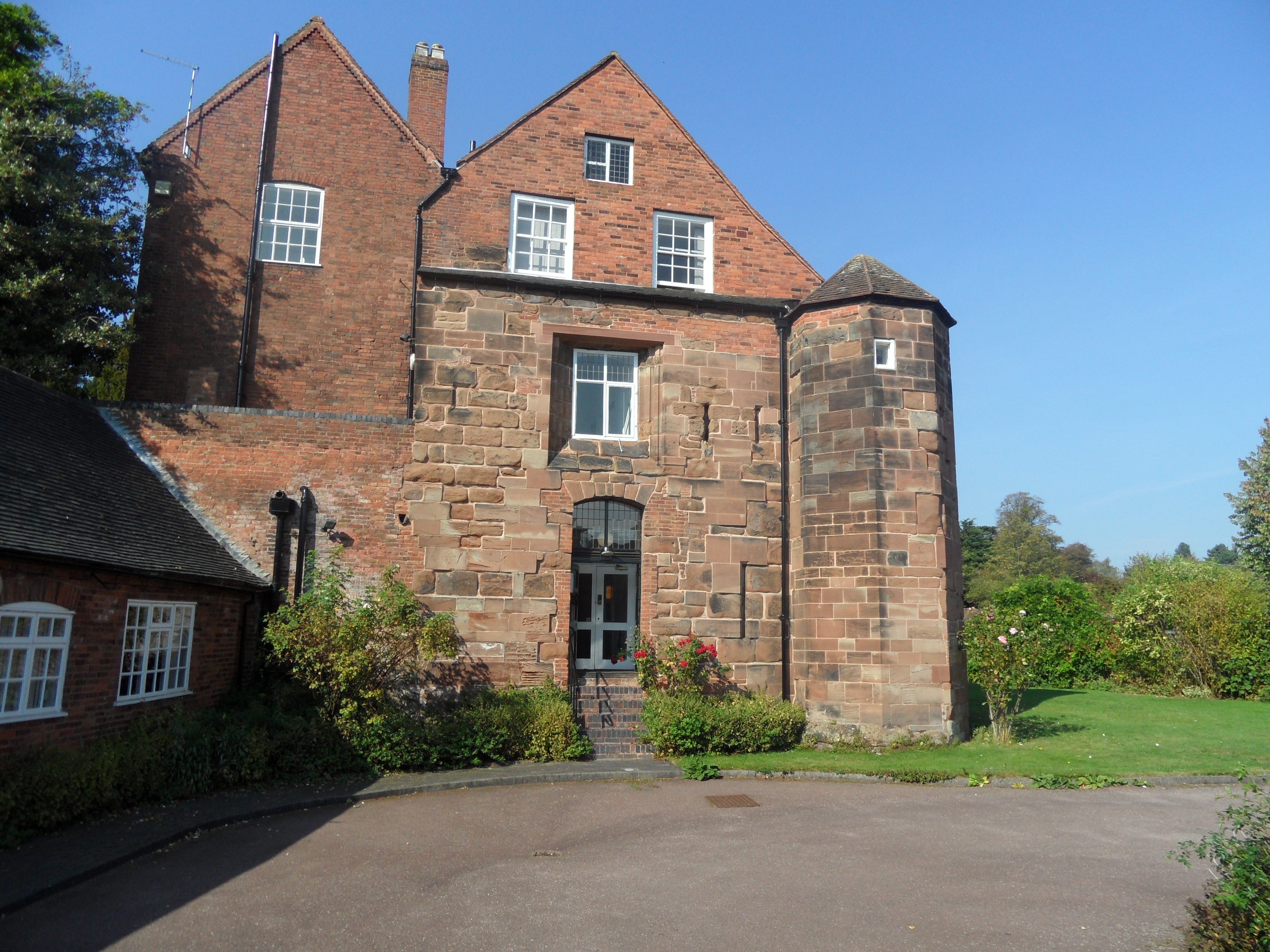
4)      St Mary’s House in The Close

In the Lichfield Records Office there is a copy of Lomax’s Pictoral Book of Lichfield, edited by Alan J Bull. It describes St Mary’s House as the oldest house in Lichfield and says that the East & South walls are part of the original building which dates back to before 1321 and formed part of the Close’s defences – at the base the walls are 6ft thick and you can still see the arrowslits. The book goes on to say that tradition has it that below this building are underground passages leading to St Chad’s, White Hall, the Friary, St John’s Hospital and the Old Brewery on Sandford St.

5)     Beacon Street again!

Vickie’s Aunt remembers seeing a very large tunnel somewhere in the vicinity of Beacon St, which she describes as being whitewashed and large enough for a coach & horses to get through.

6)      Tudor Tea Rooms

On their own website, there is a description of a passage going from their cellars to the Cathedral. They speculate that it may have been dug out  during the Civil War. Apparently, the “passage has been followed for some distance in recent years, but is too dangerous to pursue further”

7)      Greenhill

A rumour of a tunnel behind a building on Greenhill, which used to be a pub called the Spread Eagle. (You can still see the archway for the coaches & the building is called ‘Spread Eagle House’).

As well as discussing tunnels, I’ve also been talking to people recently about the importance of stories & legends, like these. Do we really need to get to the truth or should we leave them be & enjoy them for what they are? I still haven’t made my mind up, so, I’ll leave it for you to decide in this case.

Therefore, this next part is a bit like a Choose your Own Adventure book (remember those? I used to have my fingers bookmarking about 5 different options at a time!). If you would like to investigate the truth behind Lichfield’s mysterious tunnels you could start by clicking here or exploring some old maps of Lichfield here. Just suggestions though, can’t guarantee you’ll find the answers!

If you’re happy to accept the stories as they are, then relax and perhaps go & make yourself a nice cup of tea 🙂

Edit:

I’ve been told about another tunnel by someone on Twitter – one between Gaia Lane and the Cathedral. Apparently it leads to a house that used to be used as a laundry/servants quarters. A relative of my tunnel informant has actually been in the tunnel, and says it is blocked off. We’re thinking laundry tunnel, servants passage – anyone else know anything?

Interestingly there was a daughter and mother,  Ellen Stone and a Mary Skelton, both described as a ‘Laundress’ living at Gaia Lane on the 1851 census. Going off topic somewhat, Ellen’s son Henry lived with them. He was illegitimate and there is some interesting speculation on who his Father may have been. You can read more at the Stone Family History site here.

Edit: 10/3/2012

I’ve come across a scribbled note I made some time ago which says there is a tunnel underneath Farewell Church. Interestingly, there is a work of semi- fiction set at the nunnery that preceded the church. The story is set at the time of the dissolution of the monasteries and is called ‘A Tale of Fairwell’. The last scene of the book is set in ‘the subterranean vaults of Fairwell Priory’.

Also, Hanch Hall has a confirmed underground passage of some description – the listed building description says there are ‘extensive brick vaulted cellars with vaulted passage or drainage channel leading into the park’.

You say Leamonsley, I say Leomansley

I still don’t think anyone is quite sure how this area of Lichfield is actually spelled. It’s not suprising, I’ve come across at least five different versions over the last five years! I remember there was an issue with signposts some years ago too. I’m going with Leomansley for consistency as this seems to be the current spelling that most would recognise.

Accoring to a transaction on pre-conquest Lichfield from the Staffordshire Archaeological & Historical Society, the name Leomansley contains elements indicating there may have been a Welsh settlement here around the 6th century.

Lemansyche

In ‘Lichfield: The cathedral close’, A History of the County of Stafford: Volume 14: Lichfield (1990), pp. 57-67, it tells us that

“in the 13th century the cathedral was described as being between Lemansyche and Way Clife. Gaia Lane may have been called Lemansyche as Shaw Lane, the extension of Gaia Lane on the west side of Beacon Street, is in the direction of Leamonsley”.

Edit 2/2/2012 : The origins of placenames is a fascinating but tricky subject. I did read a few days ago that ‘sike’ or ‘sitch’ could be a regional names for a small streams (especially one flowing through flat or marshy ground). Apparently the word was used especially when describing boundaries. It comes from the OE ‘sic’ and in the Midlands became ‘sich’ by the 1500s (2).

So could I be right in thinking that the Lemansyche referred to might be Leomansley Brook, which runs across Beacon Park? This would be in keeping with the boundary idea and also with the stream over marshy ground. As this excerpt from wikipedia says ‘The land on which Beacon Park now stands was originally low lying, poorly drained pasture alongside the Leamonsley Brook. The Museum Gardens and Recreation Grounds were the site of Bishops Fish Pool or Upper Pool. The pool was created when a causeway was built on Beacon Street in the 14th century separating it from Minster Pool. The area around Bishops Fish Pool in all directions was waterlogged marshland, this area south of Bird Street became known as the moggs from the 15th century and later Swan moggs’.

Is this feasible? As I said, a tricky subject, even for experts, and especially for dabblers like me!

Leamonsley

We are told by the County History that that the hamlet* of Leamonsley grew up around the fulling mill on Leamonsley brook in the early 1790s. In 1841 census there were 13 households, including that of the tenant of the mill; with the number rising to 27 households in 1851.

* a term often used to describe a village without a church

Lemondsley

In 1806, the Rev Thomas Harwood referred to “four closes of land, pasture and meadow, lying next together near the said city (Lichfield), called Lemondsley for which the rent of 10s per annum is now paid”.

Lemmonsly

In the book “Trade Tokens” by J.R.S.Whiting, and on http://www.windmillworld.com, there is a reference to a twopenny token of Lemmonsly Worsted Mill, Lichfield (John Henrickson). Henrickson is a “calico, cotton and shirting manufacturer” . The token shows a mill with trees at sides, and river. On the reverse is the arms of Lichfield between oak branches, and text “One pound note for 120 tokens”. A picture can be seen on Flickr following this link.

www.flickr.com/photos/30084068@N08/3305680975/in/photostream

There is no date on the token but John Henrickson let and ran the mill from around 1810 until he went bankrupt in 1815.

Leomansley Mill, now that sounds like an interesting place………..

Sources

‘Lichfield: The 19th century’, A History of the County of Stafford: Volume 14: Lichfield (1990), pp. 24-32. URL: http://www.british-history.ac.uk/report.aspx?compid=42338 .

(2) Edit 2/2/2012 http://voices.yahoo.com/shallow-shoal-shoot-sike-sitch-origins-forms-histories-5293647.html

The Grave of Poor Bessy Banks

I spotted a place labelled Bessy Banks’ Grave on the 1815 Ordnance Survey drawing of Lichfield by Robert Dawson 1815.

Immediately, I thought of the story of Kitty Jay on Dartmoor. A little investigation has revealed a few details. In ‘History of the City and Cathedral of Lichfield’ by John Jackson (1805), I found the following;

“…of Betsy Banks grave* once the famous rendezvous of lovers….now no more is remembered than that poor Betsy is said to have fallen victim to hapless love.

*there is a spot in a field in Lichfield still distinguished by that name”

Anna Seward wrote to her friend Honora Sneyd about the place in a letter dated May 1772, that she described as ‘Written in a summer evening from the grave of a suicide’. I’ve only included the first part as its quite long.

“It suits the temper of my soul to pour
Fond, fruitless plaints beneath the lonely bower,
Here, in this silent glade, that childhood fears,
Where the love-desperate maid, of vanish’d years,
Slung her dire cord between the sister trees,
That slowly bend their branches to the breeze,
And shade the bank that screens her mouldering form,
From the swart Dog-Star, and the wintry storm….”

Another reference can be found in one of David Garrick’s letters.  He wrote that “the name Dimble is given to a sunken road leading north from Lichfield past a spot, supposedly haunted called Betty Honks Grave. Two sister trees form an elegant arch over a stream”.

By 1791, it was found that the sister trees had been recently cut down.

So who was Bessy Banks, did she really exist? If so, is her grave still there, now unmarked and unremembered?

Edit 5/9/2011

I recently had the St Chad’s tithe map (1849) out in Lichfield Record Office, looking for something else. A whole plot of land is listed as ‘Bessy Banks’. Born a Lichfeldian has kindly worked out where the stream in this area would have been. Taking into account this and the tithe map it seems that ‘Bessy Banks’ was somewhere in the region between Dimbles Lane and Greencroft.
John Jackson’s description suggects that in 1805 the story is already an old one. It does seem a fairly well-known tale, to have actual places on maps marked after it, as well as being mentioned by Garrick (albeit with the name Betty Honks!) & Seward.  Was it just a made-up story, or did it arise from actual events? I wonder when (and why?) the people of Lichfield stopped telling the story? Or could there even still be people who could tell us the tragedy of Lichfield’s ‘love-desperate maid?’

Edit: 15/4/2012

A notice in the Lichfield Mercury 20th February 1914 lists a lot for sale as garden land, known as Bessy Banks, adjoining a plot of arable land let by T Chapman and located next to Gaiafields House and Gaia Fields Cottage.