
As I mentioned in the last post about the West Gate, some other remnants of the Close’s medieval defences are visible. I’ve marked the ones I know about, on the map below, with a bit of information on each. I’m sure there’s probably more, and we could probably work out where the other defences were, but it’s a start!
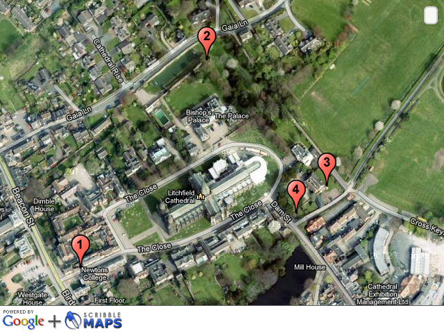
1. Site of the West Gate – see previous post here
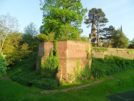
2. Remains of North East Tower & ditch. A scheduled monument, sometimes known as the Bishop’s Tower, this was part of the original, medieval bishop’s palace. The pastscape record can be seen here. A description of the tower and how it fitted into the rest of the palace can be found in several books on the Cathedral & Close (1) and is based on a plan that was held in the Bodleian Library (is it still there?). A plan drawn from this can also be found here.
At the north east corner was a tower fifty two feet high and each of its ten sides thirteen feet on the outside. It was called the bishop’s tower and the ruins yet remain. Adjoining this tower was a square room with stone stairs leading to the top on the north west of which was an apartment with a cellar underneath twenty two feet in breadth and sixty three feet in length. The bishop’s lodging room was forty feet by thirty two with a leaden roof and cellar underneath. On the north side of this room was a large chimney piece opposite to which a door led to the dining room sixty feet long and thirty broad. At the east end was a door opening into the second tower which consisted of five squares eleven feet in width and thirty two in height. There were two apartments each twenty feet by seven separated from each other by the large hall chimney, , the lady’s chamber…the brewhouse…and the kitchen.
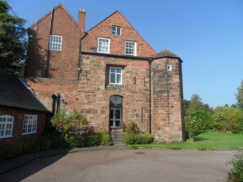
3. St Mary’s House. Incorporates a turret and part of the Close wall on the east and south side. Not only are there are arrow slits, but there are also rumours of a secret tunnel down below….Actually, it’s not that secret as loads of people seem to have heard about it.
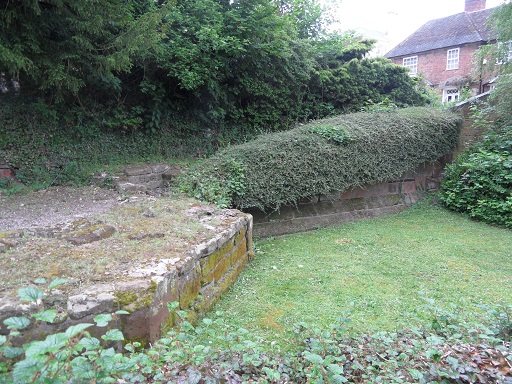
4. Remains of Eastern Tower of South East Gate. This description comes from the ‘Lichfield: The cathedral close’, A History of the County of Stafford: Volume 14: Lichfield
The gate built by Langton at the south-east corner of the Close had two towers. The eastern one, whose base was excavated in the late 1980s, was a half-octagon with 12-ft. sides. The western tower was presumably of similar dimension. The gate had a portcullis in 1376. There was a drawbridge, still in existence in the earlier 18th century, which crossed the outflow of water from Minster Pool, and also a wicket for pedestrians. The gate was removed in the mid 18th century in order to improve access for coaches into the Close.
There’s also this bit of wall behind the Chapters coffee shop, which provoked a bit of discussion on Brownhills Bob’s Brownhills Blog, and with Annette Rubery. Especially about what that recess is!

While I was having a flick through googlebooks trying to find information on the subject, I came across an interesting snippet. Adrian Pettifer, in ‘English Castles: A County Guide’ makes the point that that unlike the majority of cathedral cities, there was no wall around the city of Lichfield as a whole.
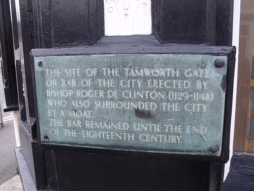
So whilst the Close was protected by a strong wall, a ditch, 50ft towers, drawbridges and portcullises (when you put it like that it really does sound like a castle!), what did the rest of the city have? Well, there was a ditch. It’s thought even this was used more for controlling traders coming in and out of the city, than for defences. An archaeological dig carried out on the Lichfield District Council carpark in Frog Lane, also confirmed that the ditch was used as the city dump and found a variety of material, including it appears, the dog from Funnybones. There were gates too, the positions of which are still marked by plaques. Again, though it’s thought these might not have been defensive. I think the ditch and the gates deserve a post of their own, so I’ll come back to them another time.
Credit: Ell Brown (taken from flickr photostream)
This will also give me time to think about my latest question (one I’m sure has been thought about and answered by clever people already!). Was the city of Lichfield defended, along with the Close? And if not, then why not? Of course, if anyone has any ideas about this in the meantime, please let me know!
Footnootes:
(1) This particular description is taken from ‘A short account of the city and close of Lichfield by Thomas George Lomax, John Chappel Woodhouse, William Newling
(2) Thanks to this website http://gatehouse-gazetteer.info/English%20sites/3329.html for pointing me in the direction of some great links.
(3) I’ve also used this book From: ‘Lichfield: The cathedral close’, A History of the County of Stafford: Volume 14: Lichfield (1990)

Fascinating stuff, Kate! I always enjoy your enlightening posts about my great home city. I look forward to reading more bout the gates and moat.
LikeLike
Thanks Simon. Think it might be nice to have a walk along it!
LikeLike
Kate,It could be the story of the Lichfield Martyrs passed into common
knowledge and nobody wanted to invade a city that had suffered so
much,Also with St Chad’s well it was revered as a place of pilgrimage,
Once again you have put together a top class blog.
LikeLike
Hi off the top of my head (as I am away at present so have no notes to refer to at present)
Lichfield is situated in a valley or vale, as such is overlooked from hill around it so not easily defended. It was also situated amongst marshy land. In fact what we know as Leomansly , Beacon Park, minster Pool and Stowe Pool were known as the Moggs and provided a natural defence for both the town and Cathedral
Around Wade St/Frog Lane is Castle Ditch, but we do not know if this was Saxon or later, and if there was a fort but nothing is left. This protected the approach to Lichfield from the direction of Wall and the Roman Roads (which any army would use). There was talk years ago of stone age/Neolithic fort/castle no idea where. St Michaels Church was talked of as a possible location.
Lichfield in Saxon times was the Ecclesiastical centre of Mercia whereas Tamworth was the defensive place, situated where it is by Ethelfleda (Lady of the Mercians and daughter of Alfred the Great) who rebuilt many towns (and in some cases relocated them) as a defence against the Vikings to the North and North East in Danelaw). Stone was the Saxon capital for many years. Wall was the Roman fortification covering two important Roman Roads, which bypassed Lichfield at that time.
Lichfield Cathedral is situated on what was the hardest ground and protected on one side by the Moggs. In fact access to the town was via 2 causeways (Dam St and Bird St). It was defended to protect the shrine of St Chad and the Cathedral.
The town (such as it was in the 12th century) was surrounded by a combination of ditch and palisades…I do not know if it was a grand as stone walls and moat, that we know of but we have little to go on. Probably rubble walls, but there were gates i.e. at George Lane (which also follows the line of the old ditch) uphill one way to Greenhill and the other way towards the Moggs (Stowe Pool area) which provided the next line of defence. Also a gate at St Johns ,(as discussed in another blog). I think it was for simple protection and some control of Pilgrims to the shrine.
The Friary was a complex place and had its own security to an extent, but close enough for the Monks to make their way into the Close if need be.
All this sounds scattered but in modern terms it was zoned security i.e. individual places made secure rather than struggling to protect a very large area. Also we must remember the landscape of the area was very different. Lichfield had marshy land tracts as well as heavy woodland stretching towards Tamworth and Cannock and was the hunting grounds of the Kings of Mercia.
I think at the time of the Civil War, the town walls were not there or poor repair but I remember a lecture (think Howard Clayton..Probably wrong) that the old defences became part of the trench siege works during the 3 sieges of the Close, around Beacon Street etc.
Around the Market square grew up the medieval town and City, and Stowe was a hamlet with St Chads well (where he baptised) and Church.
If I remember right, St Chad is mentioned several times in Bede’s Ecclesiastical History of the English People and Lichfield in the Saxon Chronicles.
As an aside, there is a Ghost story that on hot summer evenings, you can hear in Gaia Lane (near Bulldog Lane/St Chads Road) the sound of soldiers marching….the story is they were a patrol or picket working up towards the high ground above the cathedral and they were ambushed. Many of us have heard something…one for an investigation another time.
I hope this helps and not cause confusion
LikeLike
That’s really helpful and interesting thank you. And I love ghost stories. All we need now is a hot summer evening to go and have a listen!
LikeLike
Thank you both Kate and David for such wonderful posts. I could just go on reading this stuff forever!
LikeLike
Sorry Ian, I missed this before, thank you! David’s contribution is brilliant. You know, the more I do, the more I think that the geeky archives stuff I do is ok but real life stories, memories and experiences really help to bring things to life. Obviously the further back you go, the harder that gets 😉
LikeLike
Is Chapters Coffe Shop the one with the raven…
“…and at the Coffee House in Lichfield, I was shown another raven’s head, whose upper mandible turned downwards and crossed the lower, but the under one straight, only much longer than the upper…”(Diagram shown)
Robert Plot (1686)
LikeLike
Pingback: Trailgating | Lichfield Lore