
I stopped by the Outer Friary carpark yesterday and hovered around until one of the archaeologists was near enough to pounce on (not literally, there was a metal fence between us). He very kindly explained that they thought they’d found a victorian house, but that they would keep looking in case any evidence of earlier activity had survived e.g. field boundaries. One thing he did mention that I thought was fantastic was how people passing by were offering their interpretations and anecdotes – one chap apparently swore that he remembered buying records out of the cellar you can see on Dave Gallagher’s photo below (which he has very kindly said I can use!).

Hope the hi-vis jacket is waterproof! Photo by Dave Gallagher
There are more of Dave’s photos on the ‘You’re probably from Lichfield, Staffs if………’ Facebook group, accompanied by some interesting discussions about what the dig has revealed.
Whether people have read about the dig on Lichfield Live, seen Annette Rubery’s great post, been made aware of what’s going on thanks to Brownhillsbob’s blog, have joined in the discussion on Facebook, or have just stopped by in the street to wonder what’s going on I think its great that we’ve all had the opportunity to see this. Of course with archaeology we all want exciting things to be discovered, but even if the archaeologists don’t turn up anything that they consider ‘significant’, it’s allowed people to witness a dig (that isn’t on Time Team) and got people interested in what’s going on around them, which is never a bad thing. Plus it’s given us all something to talk about other than the weather….
Edit 14/5/2012
Walking past on Saturday I noticed this brick on the side of the excavations. I have found a reference to a ‘Mr Roberts’ brickyard at Streethay, near Lichfield’, in a book from 1869 (Burton on Trent: Its Water And Its Breweries by William Molyneux) which may be where this brick was made. (Mr J Roberts from Streethay also won second prize for his pony at the annual show of The Staffordshire Agricultural Society in 1867!) According to the pastscape record there was a post-medieval brickworks, including a yard and a claypit, at the helpfully named ‘Brickyard Farm’ at Streethay. The brickworks and the associated pits show up brilliantly on the 1883 OS map, sitting near to the canal, inbetween Bearshay and Hilliards Cross.
I think bricks are underestimated so I think I’m going to do a post in honour of the not so humble brick.
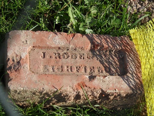
A local brick
Update: 28 May 2012
The dig has been completed and the trenches have been filled in. There’s a short post here from Lichfield District council, who expect a full report to be available in three to six months.

True, Kate, it’s great to see how much interest there is, and I for one have never seen a dig before. I wonder if the cellar is older than the rest?
LikeLike
The cellar reminds me of one in a house I know that is about 180 years old, but other than that I just don’t know. You know I was just looking at a map again and that pub can’t be too far from where they are digging. There’s a comment on the previous post from someone who remembers it being around there too. I was wondering if the tithe map would show things more clearly? Would certainly give a good picture of the street in the mid 1800s anyway 🙂
How does this previous dig in the area fit into it too – I’m getting confused now !! http://www.heritagegateway.org.uk/Gateway/Results_Single.aspx?uid=MST11474&resourceID=1010
LikeLike
Yes, I must admit, it’s murky. I stuck the grid reference on that document in the UK grid reference finder and found where they were digging in 2002 and stuck a red spot on roughly where the cellar is in the current dig (I’ve done this as an update on my original blog post if you want a look). It’s not that far apart. But then, this tells us nothing really. Would be good to lay hands on a reasonably detailed 19th-century map, though. I’m not surprised about some of it being Victorian – the tiling, for instance.
LikeLike
Pingback: Lichfield’s Friary Outer Development Uncovers 18th Century Pub | Lichfield Live
I’m confused, because I remember the Turk’s Head in the 80’s??
LikeLike
I think we were wondering whether there was an older pub replaced by a more modern pub on a slightly different site? If you remember it the 1980s then I guess it might have been demolished to make way for the Swan Rd extension? All the maps I’ve been able to lay my hands on are pre 1980s. Was thinking the tithe map would be interesting as it would show what the street looked like in the mid 1800s which is more or less the same era as they are saying what they’ve uncovered so far.
Can you remember what the pub looked like – did it have one of those carriageways like the Kings Head as it was apparently a coaching inn?
LikeLike
I remember the Turks Head, it was set back off the road and did not have a Coach entrance, access was at the back. The old site now forms Swann Road and the car park opposite the Friary Car Park. The whole lot was grubbed out cellar and all.
LikeLike
Brilliant, thanks Hugh. I think that’s where Annette had thought it was based on the details of the dig they did there and it’s great to get confirmation. You’d think as it was a coaching inn, it would have had a coach entrance, so I wonder if this helps to support Annette’s theory that the original pub was replaced?
Cheers, Kate
LikeLike
I remember when I was a student and worked on an archaeological site, my dad used to ask every day, ‘have you found anything yet?’. The answer: a 17th century house with a medieval moated house underneath it, with hints of even earlier habitation, wasn’t good enough. He meant, had I found any TREASURE yet.
This the thing with museums, metal detecting and sometimes even Time Team – they give the impression that it’s all about the ‘finds’!
Have fun, though 🙂
LikeLike
I agree with you Diane. Mind you, I get excited by bits of pottery & the odd clay pipe! Let’s face it, the bar has been set pretty high in these parts by a certain hoard….. In 2002, they found a medieval pub not too far away from where they are digging now. One of the discoveries was a toilet, which gave clues to the punters’ diets! http://www.culture24.org.uk/history%20%26%20heritage/archaeology/art16886 So a mineralised raspberry might not be treasure in quite the same way as a silver sea horse, but that kind of discovery is good enough for me 🙂
LikeLike
Have you seen the interesting 1920s map that someone posted on the Lichfield history Facebook group? It shows the Turk’s Head as Hugh remembers it, with stables around the back, and the pub seems to be joined to a butchers shop by an archway. The dig has got rough cobbles on one side that looks like they’ve uncovered a drive or passageway, which would be logical, and the butchers shop’s footprint looks similar to the shape of the plot they are digging.
LikeLike
PS Interesting comment from John on my blog: http://www.annetterubery.co.uk/?p=3551#comments
LikeLike
This is great stuff thank you. Sounds obvious I suppose, but something I’ve been doing this week really brought it home to me how fantastic a mixture of research and memories can be, with each one adding to the other and filling the gaps. Obviously if we go a bit further back the memories part gets a bit trickier 😉
LikeLike